
Today marks World Population Day 2025, as humanity reaches 8 billion people. The milestone raises a fundamental question: How do we ensure every person, in every place, has access to the services they need?
At Dev-Afrique, we believe the answer lies in strengthening geospatial data ecosystems—the complex networks of data generation, analysis, and operationalization that determine whether population insights translate into real impact.
In our role developing and deploying geospatial interventions across Africa, we have seen firsthand how location-based intelligence transforms development outcomes across the continent. From evaluating global initiatives to designing locally-led solutions, our work spans the entire ecosystem that turns population data into life-changing action.
Proving What Works: Rigorous Impact Assessment
Our comprehensive evaluation of WorldPop‘s population estimates across Africa revealed the transformative power of accessible, accurate geosptial data. Through 43 stakeholder interviews and rigorous impact analysis, we documented how population data creates measurable change:
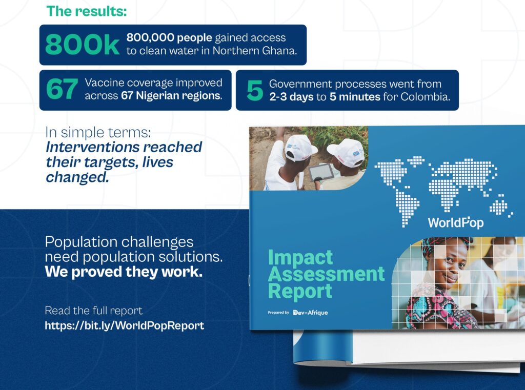
But beyond individual success stories, our assessment revealed a deeper truth: impact happens when high-quality data meets strong local capacity to act on it. The most successful interventions shared a common thread—local teams with the skills and systems to transform geospatial insights into targeted action.
Building What’s Missing: Ecosystem Solutions
Understanding gaps is one thing. Building solutions is another. Through The Umbrella Fund | Geospatial Interventions, we are addressing the geospatial ecosystem challenges we have identified across Africa.
Our Geospatial Value Pipeline assessments in Nigeria and the Democratic Republic of Congo revealed similar patterns: excellent data existed, but the infrastructure to operationalize it remained underdeveloped. Local organizations needed catalytic funding, technical support, and sustainable capacity-building pathways.
The Umbrella Fund for Geospatial Interventions tackles this directly:
- In Nigeria: Institutionalizing geospatial training within accredited academic institutions, creating sustainable pathways for health workers to gain location-data skills
- In DRC: Establishing regional training hubs across 16 provinces, building decentralized capacity for provincial health teams
This isn’t traditional development funding. It is ecosystem building—empowering local organizations to lead solutions that strengthen how geospatial data improves health service delivery across the continent.
The Bigger Picture: From Data to Impact
What we have learned from both evaluation and implementation is this: the future of development data is better ecosystems.
Countries need stronger capacity to analyze, interpret, and act on the data they already have. They need systems that connect data producers with data users. They need local ownership of the tools and insights that drive decision-making.
As we mark 8 billion people on Earth, the challenge isn’t counting them—it is building the systems that can serve them all effectively. That requires moving beyond individual tools toward comprehensive ecosystem thinking.
At Dev-Afrique, we bring this perspective to every engagement. Whether evaluating existing initiatives or designing new ones, we understand that lasting impact comes from strengthening the entire pipeline from data to action.
Behind every statistic—800,000 people with clean water, improved vaccine coverage, streamlined government processes—are human lives changed because the right data reached the right people at the right time.
That is the future we are building. One ecosystem at a time.
Learn more about our geospatial initiatives at devafrique.com/insights or explore funding opportunities at umbrellafund.org
lipitor generic
lipitor generic
levitra price
levitra price
reglan injection
reglan injection
cipronex
cipronex