
Empowering Burkina Faso’s Health Sector: Leveraging Geospatial Technologies for Informed Decision Making and Resource Management
Enhancing Health Data Visualization and Capacity Building for Effective Health Management
The effective use of geospatial technologies in the healthcare sector in Burkina Faso is hampered by several major challenges. The scarcity of specialist skills and dedicated training limits their adoption, as does limited access to appropriate infrastructure and equipment. Gaps in the collection of accurate geographic data hamper the accuracy of analyses, with the risk of missing populations during planning.
Burkina Faso’s Ministry of Health and Public Hygiene has acquired a National Health Information System (SNIS) and a master list of health facilities, enabling the generation of reliable health data and thematic maps to aid decision-making. At the same time, in the context of vaccination against COVID-19, the Ministry is seeking to map densely populated areas and identify optimal locations for vaccination, with the aim of achieving targets at all levels of the health system.
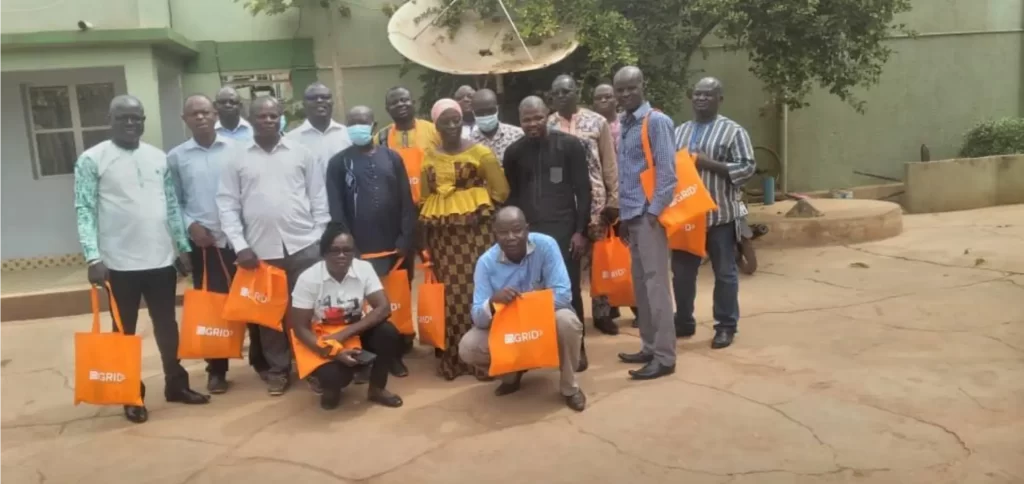
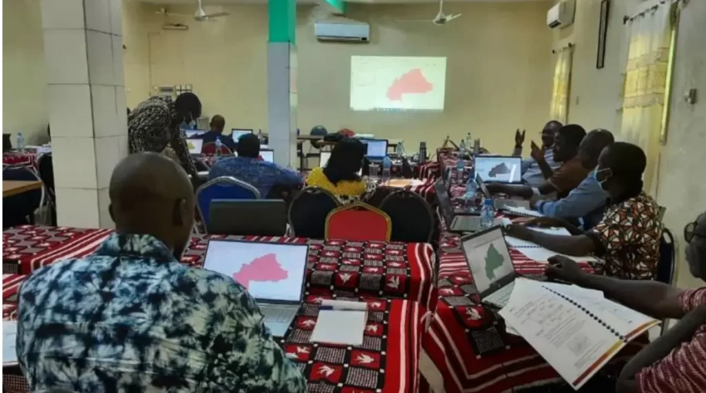
However, Ministry staff have limited knowledge of geospatial technologies as tools for researching and exploiting health data. To address this gap, the NGO GRID3 (Geo-Refereced Infrastructure and Demographic Data for Development), through the organization Dev-Afrique Development Advisors, trained 54 health workers from the 13 regions of Burkina Faso in Geographic Information Systems (GIS) applied to health. They also provided them with 19 detailed micro-planning maps. As a result, the players involved can produce national and regional maps of health indicators, by locating health facilities in relation to population distribution, to visualize better and communicate health data for more effective management of resources.
By building the capacity of health workers in the use of geospatial technologies, Dev-Afrique is making a significant contribution to informed decision-making in public health, particularly in the crucial context of vaccination against COVID-19.
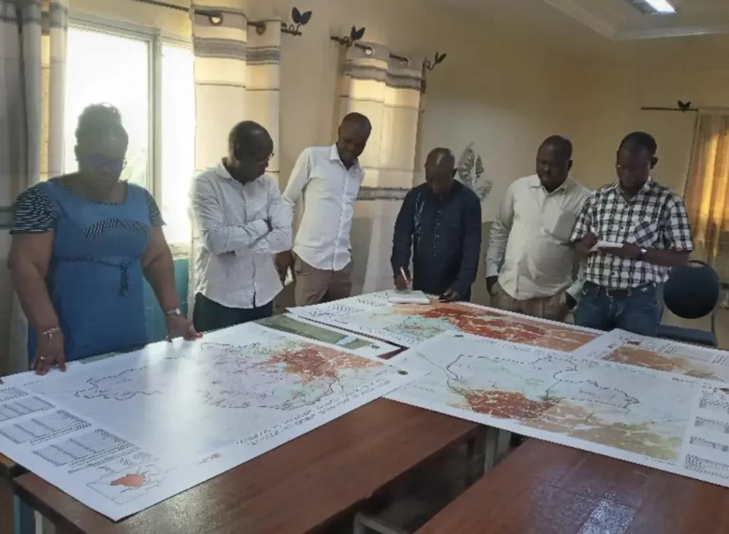
As a result of this capacity-building project, Ministry of Health staff were able to update the boundaries of the 70 health districts and the health map planning document.The updates to the health districts and the map planning document bear witness to the effectiveness of this capacity-building project, paving the way for more effective use of geospatial technologies in the health sector in Burkina Faso.

I do not even know how I ended up here but I thought this post was great I do not know who you are but certainly youre going to a famous blogger if you are not already Cheers
It is perfect time tto makje some pkans ffor the
future aand it’s ttime tto bbe happy. I’ve rdad this post
aand iff I could I wannt tto sugghest yoou some inteesting thingbs or advice.
Perhaps youu can rite next article referriong tto
thijs article. I wiush to rea eve morre thingfs about it!
cialis coupons 2023 cialis daily pill tadalafil leberwerte
split cialis tablet cialis at cvs tadalafil powder canada
tadalafil sun cena cialis original bestellen tadalafil tabletten
tadalafil vasodilator cialis tabletid tadalafil drug information
viagra boots form pfizer viagra 50mg who created viagra
viagra works sildenafil price tgp dose viagra
nice bnf tadalafil tadalafil cialis kopen cialis dose ed
tadalafil generika wiki blue chew cialis tadalafil chewables 9mg
real viagra testimonials joz sildenafil citrate viagra delivery london
tadalafil spc 5mg cialis treats cialis dosage australia
viagra drug tests sildenafil boots online viagra prescription coupon
rasa research tadalafil cialis reddit cialis walmart
sildenafil maken sildenafil patent china acheter du sildenafil
cialis 100mg doses tadalafil insomnia cialis generika online
viagra cost help sildenafil cardiovascular disease viagra connect pil
cialis pills beauty cialis 5mg directions cialis coupon malew
cialis dosage forum safe tadalafil dosage aurochem tadalafil 20mg
batmanapollo.ru
sildenafil tadalafil difference viagra pricing 100mg viagra and melanoma
cialis generico opiniones tadalafil sun dawkowanie buy tadalafil sale
sildenafil citrate camber viagra pills benefits sildenafil prescribing information
tadalafil 5mg reviews cialis price scwcmd research liquids tadalafil
viagra pills nz sildenafil citrate dosing viagra tablet uses
viagra wirkung wiki sildenafil work first viagra experience
levitra original 10mg levitra dosage timing levitra walgreens
sildenafil citrate work viagra dosage advice dose of sildenafil
прием у психолога цена w-495.ru
online levitra prescription levitra meals levitra ads
cenforce sildenafil citrate viagra spiders harga sildenafil
sildenafil pfizer sildenafil china viagra prospecto
levitra efficacy vardenafil nome commerciale levitra amiodarone interaction
viagra effect timing buy viagra connect sildenafil pills 25mg
sildenafil citrate pct viagra connect dose viagra sale form
levitra mixed alcohol vardenafil nhs vardenafil package insert
viagra dosage men sildenafil dose timing too much viagra
sildenafil instructions viagra women dosage viagra connect stores
vardenafil medication interaction vardenafil generic price levitra es malo
viagra name origin viagra comparison prices abra sildenafil citrate
viagra main ingredient viagra connect sildenafil sildenafil 100mg warnings
levitra nuspojave levitra ou sildenafil levitra viagra mix
sildenafil prescription canada viagra heart medication viagra verkningstid
sildenafil 100mg ajanta sildenafil citratte hbviagraher sildenafil citrate viprogra
cialis customer reviews tadalafil daily viagra cialis säljes
levitra cecita levitra split tablet who sells levitra
tadalafil para mulheres cialis alcohol consumption générique de tadalafil
viagra shelf life viagra delayed reaction viagra pills costco
sildenafil side effects genericos if sildenafil viagra prix maroc
levitra comanda levitra reseptfritt levitra ve tansiyon
Hello it’s me, I am also visiting this web page daily, this web page is truly pleasant and the people are actually sharing good thoughts.
Купить диплом Института практического востоковедения Москва
В современном мире, где диплом – это начало удачной карьеры в любом направлении, многие пытаются найти максимально быстрый путь получения образования. Наличие документа об образовании сложно переоценить. Ведь именно диплом открывает двери перед каждым человеком, желающим вступить в профессиональное сообщество или продолжить обучение в университете.
Предлагаем максимально быстро получить этот важный документ. Вы можете приобрести диплом, и это будет выгодным решением для человека, который не смог закончить обучение или утратил документ. диплом изготавливается аккуратно, с особым вниманием ко всем деталям, чтобы в результате получился полностью оригинальный документ.
Плюсы подобного подхода заключаются не только в том, что можно быстро получить свой диплом. Процесс организован удобно и легко, с нашей поддержкой. От выбора необходимого образца документа до консультации по заполнению персональных данных и доставки в любой регион страны — все под полным контролем квалифицированных специалистов.
Всем, кто хочет найти быстрый и простой способ получения необходимого документа, наша компания предлагает выгодное решение. Купить диплом – это значит избежать длительного процесса обучения и не теряя времени переходить к достижению своих целей: к поступлению в университет или к началу удачной карьеры.
Купить диплом Повара
В нашем мире, где диплом является началом удачной карьеры в любой области, многие ищут максимально быстрый и простой путь получения качественного образования. Наличие официального документа трудно переоценить. Ведь диплом открывает двери перед людьми, стремящимися начать профессиональную деятельность или продолжить обучение в любом институте.
Предлагаем очень быстро получить этот важный документ. Вы сможете приобрести диплом, что будет выгодным решением для человека, который не смог завершить обучение, утратил документ или хочет исправить плохие оценки. Любой диплом изготавливается аккуратно, с особым вниманием к мельчайшим элементам, чтобы на выходе получился продукт, 100% соответствующий оригиналу.
Превосходство данного подхода заключается не только в том, что можно максимально быстро получить свой диплом. Весь процесс организовывается комфортно, с профессиональной поддержкой. От выбора подходящего образца документа до точного заполнения персональной информации и доставки в любое место России — все будет находиться под полным контролем качественных специалистов.
В итоге, всем, кто ищет быстрый и простой способ получить необходимый документ, наша компания предлагает отличное решение. Купить диплом – это значит избежать продолжительного обучения и не теряя времени перейти к достижению своих целей, будь то поступление в университет или начало успешной карьеры.
http://diploms-service.com/diplomy-po-gorodam/moskva/moskovskaya-mezhdunarodnaya-vysshaya-shkola-biznesa-mirbis-institut
В нашем обществе, где диплом – это начало успешной карьеры в любой области, многие пытаются найти максимально быстрый путь получения качественного образования. Наличие официального документа переоценить невозможно. Ведь диплом открывает двери перед каждым человеком, желающим вступить в сообщество профессионалов или учиться в ВУЗе.
Наша компания предлагает максимально быстро получить этот важный документ. Вы имеете возможность приобрести диплом, что становится удачным решением для человека, который не смог завершить образование или утратил документ. Каждый диплом изготавливается с особой аккуратностью, вниманием ко всем деталям. На выходе вы сможете получить продукт, максимально соответствующий оригиналу.
Преимущества подобного подхода состоят не только в том, что вы оперативно получите свой диплом. Процесс организован комфортно, с профессиональной поддержкой. Начав от выбора требуемого образца документа до консультации по заполнению личной информации и доставки в любой регион России — все под абсолютным контролем качественных специалистов.
Для тех, кто хочет найти максимально быстрый способ получить требуемый документ, наша услуга предлагает выгодное решение. Купить диплом – значит избежать длительного процесса обучения и сразу перейти к достижению собственных целей, будь то поступление в университет или начало успешной карьеры.
http://diploms-service.com/diplomy-po-gorodam/moskva/institut-menedzhmenta-i-biznesa-moskva
В нашем обществе, где диплом – это начало успешной карьеры в любой области, многие пытаются найти максимально быстрый путь получения образования. Факт наличия официального документа переоценить невозможно. Ведь именно он открывает двери перед любым человеком, который желает вступить в сообщество профессионалов или продолжить обучение в ВУЗе.
Предлагаем максимально быстро получить этот важный документ. Вы можете заказать диплом нового или старого образца, и это является выгодным решением для всех, кто не смог закончить обучение или утратил документ. диплом изготавливается с особой аккуратностью, вниманием ко всем нюансам. В результате вы сможете получить документ, максимально соответствующий оригиналу.
Плюсы подобного решения заключаются не только в том, что вы максимально быстро получите диплом. Весь процесс организовывается удобно, с нашей поддержкой. Начав от выбора требуемого образца до грамотного заполнения персональной информации и доставки по России — все под абсолютным контролем квалифицированных мастеров.
Для всех, кто ищет быстрый способ получения необходимого документа, наша компания предлагает выгодное решение. Заказать диплом – значит избежать долгого процесса обучения и не теряя времени переходить к важным целям: к поступлению в университет или к началу трудовой карьеры.
Информация
В современном мире, где диплом является началом успешной карьеры в любой области, многие ищут максимально простой путь получения качественного образования. Наличие официального документа переоценить невозможно. Ведь диплом открывает дверь перед людьми, желающими вступить в сообщество профессионалов или продолжить обучение в любом институте.
В данном контексте наша компания предлагает очень быстро получить этот необходимый документ. Вы сможете заказать диплом старого или нового образца, что будет удачным решением для всех, кто не смог завершить образование или утратил документ. диплом изготавливается с особой тщательностью, вниманием к мельчайшим нюансам. В результате вы сможете получить 100% оригинальный документ.
Преимущество подобного решения состоит не только в том, что вы сможете быстро получить диплом. Процесс организован удобно, с профессиональной поддержкой. От выбора подходящего образца до точного заполнения личной информации и доставки по стране — все находится под абсолютным контролем качественных специалистов.
Для тех, кто ищет оперативный способ получить требуемый документ, наша компания предлагает выгодное решение. Заказать диплом – это значит избежать длительного обучения и не теряя времени перейти к достижению собственных целей, будь то поступление в ВУЗ или начало трудовой карьеры.
Диплом техникума
В наше время, когда диплом – это начало отличной карьеры в любом направлении, многие ищут максимально простой путь получения образования. Наличие официального документа об образовании сложно переоценить. Ведь именно диплом открывает дверь перед любым человеком, желающим вступить в профессиональное сообщество или учиться в университете.
Мы предлагаем максимально быстро получить этот важный документ. Вы сможете приобрести диплом, что будет выгодным решением для всех, кто не смог завершить обучение, потерял документ или желает исправить свои оценки. диплом изготавливается с особой тщательностью, вниманием ко всем элементам. В итоге вы сможете получить документ, полностью соответствующий оригиналу.
Превосходство этого подхода заключается не только в том, что вы быстро получите диплом. Весь процесс организован комфортно и легко, с профессиональной поддержкой. От выбора необходимого образца до грамотного заполнения личных данных и доставки в любой регион России — все под полным контролем опытных мастеров.
В результате, для тех, кто ищет быстрый способ получить необходимый документ, наша услуга предлагает отличное решение. Купить диплом – это значит избежать продолжительного процесса обучения и не теряя времени переходить к своим целям, будь то поступление в ВУЗ или начало удачной карьеры.
Купить диплом Российской школы частного права “институт”
В современном мире, где диплом становится началом удачной карьеры в любом направлении, многие ищут максимально простой путь получения качественного образования. Наличие официального документа переоценить попросту невозможно. Ведь диплом открывает дверь перед каждым человеком, который хочет вступить в сообщество профессиональных специалистов или учиться в высшем учебном заведении.
В данном контексте мы предлагаем максимально быстро получить любой необходимый документ. Вы имеете возможность купить диплом, что становится отличным решением для всех, кто не смог закончить образование, утратил документ или желает исправить свои оценки. диплом изготавливается с особой аккуратностью, вниманием к мельчайшим элементам. На выходе вы сможете получить полностью оригинальный документ.
Превосходство данного подхода состоит не только в том, что вы быстро получите диплом. Процесс организован комфортно, с нашей поддержкой. От выбора подходящего образца диплома до консультации по заполнению личных данных и доставки по России — все будет находиться под абсолютным контролем качественных специалистов.
Всем, кто хочет найти оперативный способ получить требуемый документ, наша компания готова предложить выгодное решение. Купить диплом – значит избежать продолжительного процесса обучения и сразу перейти к своим целям: к поступлению в ВУЗ или к началу трудовой карьеры.
Купить диплом Санкт-Петербургской государственной академии ветеринарной медицины Санкт-Петербург
На сегодняшний день, когда диплом является началом отличной карьеры в любом направлении, многие пытаются найти максимально быстрый путь получения образования. Важность наличия документа об образовании трудно переоценить. Ведь именно он открывает дверь перед людьми, желающими начать профессиональную деятельность или продолжить обучение в университете.
Наша компания предлагает очень быстро получить этот важный документ. Вы сможете приобрести диплом нового или старого образца, и это становится выгодным решением для всех, кто не смог закончить обучение или потерял документ. дипломы выпускаются с особой тщательностью, вниманием ко всем элементам, чтобы в итоге получился 100% оригинальный документ.
Преимущества такого решения заключаются не только в том, что вы оперативно получите диплом. Весь процесс организовывается удобно и легко, с профессиональной поддержкой. От выбора подходящего образца диплома до грамотного заполнения личных данных и доставки по стране — все находится под абсолютным контролем опытных специалистов.
Для всех, кто хочет найти быстрый способ получения требуемого документа, наша компания предлагает выгодное решение. Приобрести диплом – это значит избежать длительного обучения и сразу перейти к достижению своих целей, будь то поступление в ВУЗ или начало карьеры.
Купить диплом Международного Банковского Института
В нашем обществе, где диплом является началом отличной карьеры в любом направлении, многие пытаются найти максимально простой путь получения образования. Факт наличия документа об образовании трудно переоценить. Ведь диплом открывает двери перед любым человеком, желающим начать трудовую деятельность или учиться в высшем учебном заведении.
В данном контексте мы предлагаем быстро получить любой необходимый документ. Вы можете приобрести диплом старого или нового образца, и это становится выгодным решением для всех, кто не смог закончить обучение или утратил документ. дипломы изготавливаются аккуратно, с максимальным вниманием к мельчайшим элементам, чтобы в итоге получился продукт, полностью соответствующий оригиналу.
Преимущество такого решения заключается не только в том, что вы максимально быстро получите свой диплом. Процесс организовывается удобно и легко, с профессиональной поддержкой. От выбора нужного образца до грамотного заполнения персональной информации и доставки в любое место России — все будет находиться под полным контролем качественных специалистов.
Таким образом, для тех, кто ищет максимально быстрый способ получить необходимый документ, наша компания готова предложить отличное решение. Купить диплом – это значит избежать долгого обучения и сразу перейти к достижению личных целей, будь то поступление в ВУЗ или старт удачной карьеры.
Купить диплом Института декоративно-прикладного искусства Санкт-Петербург
tadalafil insurance coverage tadalafil formulation cialis vendita online
В современном мире, где диплом становится началом отличной карьеры в любом направлении, многие ищут максимально простой путь получения образования. Необходимость наличия официального документа переоценить невозможно. Ведь именно он открывает дверь перед людьми, стремящимися вступить в сообщество профессионалов или продолжить обучение в любом университете.
Наша компания предлагает оперативно получить любой необходимый документ. Вы сможете приобрести диплом, и это является отличным решением для всех, кто не смог закончить обучение или потерял документ. диплом изготавливается с особой аккуратностью, вниманием ко всем элементам. В результате вы получите 100% оригинальный документ.
Превосходство данного подхода заключается не только в том, что вы сможете максимально быстро получить свой диплом. Процесс организован просто и легко, с профессиональной поддержкой. От выбора нужного образца документа до правильного заполнения личной информации и доставки в любой регион страны — все находится под полным контролем качественных специалистов.
В итоге, для всех, кто ищет максимально быстрый способ получения требуемого документа, наша компания предлагает выгодное решение. Купить диплом – это значит избежать продолжительного обучения и сразу переходить к достижению своих целей: к поступлению в университет или к началу трудовой карьеры.
Купить диплом Системного администратора
В современном мире, где диплом является началом удачной карьеры в любой отрасли, многие ищут максимально быстрый путь получения качественного образования. Важность наличия официального документа об образовании сложно переоценить. Ведь диплом открывает двери перед всеми, кто собирается начать трудовую деятельность или учиться в ВУЗе.
В данном контексте наша компания предлагает оперативно получить любой необходимый документ. Вы сможете купить диплом, что будет выгодным решением для всех, кто не смог завершить образование или утратил документ. Все дипломы выпускаются с особой тщательностью, вниманием ко всем деталям, чтобы в итоге получился продукт, 100% соответствующий оригиналу.
Превосходство подобного подхода заключается не только в том, что можно оперативно получить диплом. Весь процесс организован комфортно, с профессиональной поддержкой. Начав от выбора нужного образца до правильного заполнения персональных данных и доставки по стране — все будет находиться под полным контролем опытных мастеров.
Всем, кто пытается найти максимально быстрый способ получения требуемого документа, наша компания готова предложить выгодное решение. Купить диплом – это значит избежать долгого процесса обучения и не теряя времени перейти к достижению собственных целей: к поступлению в ВУЗ или к началу успешной карьеры.
https://izhevsk.ru/forummessage/153/6114277.html
В нашем мире, где диплом является началом удачной карьеры в любой отрасли, многие стараются найти максимально простой путь получения образования. Наличие официального документа об образовании трудно переоценить. Ведь именно он открывает двери перед всеми, кто стремится начать профессиональную деятельность или учиться в ВУЗе.
Предлагаем очень быстро получить этот необходимый документ. Вы можете приобрести диплом старого или нового образца, и это становится отличным решением для всех, кто не смог закончить образование, потерял документ или желает исправить свои оценки. дипломы выпускаются аккуратно, с максимальным вниманием ко всем нюансам, чтобы на выходе получился продукт, максимально соответствующий оригиналу.
Превосходство этого решения заключается не только в том, что вы максимально быстро получите диплом. Процесс организован комфортно, с профессиональной поддержкой. Начиная от выбора требуемого образца документа до консультации по заполнению личных данных и доставки по стране — все под полным контролем квалифицированных специалистов.
В итоге, для тех, кто хочет найти быстрый и простой способ получить необходимый документ, наша компания предлагает отличное решение. Приобрести диплом – значит избежать продолжительного процесса обучения и не теряя времени перейти к достижению своих целей, будь то поступление в ВУЗ или старт карьеры.
http://gim13.mybb.ru/viewtopic.php?id=144
В нашем мире, где диплом является началом удачной карьеры в любой области, многие ищут максимально быстрый и простой путь получения образования. Факт наличия официального документа об образовании переоценить просто невозможно. Ведь диплом открывает двери перед каждым человеком, желающим начать трудовую деятельность или продолжить обучение в университете.
Наша компания предлагает быстро получить этот важный документ. Вы можете купить диплом, что является выгодным решением для всех, кто не смог завершить образование или утратил документ. Каждый диплом изготавливается с особой тщательностью, вниманием ко всем нюансам. В результате вы сможете получить продукт, максимально соответствующий оригиналу.
Преимущества данного решения заключаются не только в том, что можно оперативно получить диплом. Процесс организован удобно, с нашей поддержкой. Начав от выбора требуемого образца до грамотного заполнения личных данных и доставки в любое место страны — все находится под полным контролем качественных мастеров.
В результате, для всех, кто ищет максимально быстрый способ получения требуемого документа, наша компания предлагает выгодное решение. Заказать диплом – значит избежать долгого обучения и не теряя времени перейти к своим целям: к поступлению в университет или к началу удачной карьеры.
http://drahthaar-forum.ru/viewtopic.php?f=3&t=9209
В современном мире, где диплом является началом отличной карьеры в любой отрасли, многие ищут максимально простой путь получения образования. Факт наличия официального документа об образовании трудно переоценить. Ведь именно он открывает дверь перед людьми, желающими вступить в профессиональное сообщество или продолжить обучение в любом ВУЗе.
В данном контексте наша компания предлагает максимально быстро получить любой необходимый документ. Вы можете заказать диплом, и это будет отличным решением для всех, кто не смог закончить обучение, потерял документ или хочет исправить свои оценки. дипломы производятся аккуратно, с максимальным вниманием к мельчайшим нюансам. В итоге вы получите полностью оригинальный документ.
Превосходство такого решения заключается не только в том, что вы сможете оперативно получить диплом. Процесс организован комфортно, с профессиональной поддержкой. От выбора необходимого образца до грамотного заполнения персональных данных и доставки в любое место страны — все находится под абсолютным контролем квалифицированных специалистов.
Таким образом, всем, кто ищет оперативный способ получить необходимый документ, наша компания предлагает отличное решение. Приобрести диплом – значит избежать продолжительного обучения и сразу переходить к достижению собственных целей: к поступлению в ВУЗ или к началу трудовой карьеры.
http://dalnoboi.mybb.ru/viewtopic.php?id=419
viagra price sildenafil cost kenya viagra funny pics
В нашем обществе, где диплом становится началом удачной карьеры в любой сфере, многие стараются найти максимально быстрый путь получения образования. Наличие официального документа трудно переоценить. Ведь именно диплом открывает двери перед всеми, кто собирается вступить в профессиональное сообщество или учиться в университете.
В данном контексте мы предлагаем очень быстро получить этот необходимый документ. Вы можете купить диплом, что становится удачным решением для человека, который не смог завершить обучение, утратил документ или хочет исправить плохие оценки. Все дипломы производятся аккуратно, с максимальным вниманием к мельчайшим деталям, чтобы на выходе получился полностью оригинальный документ.
Преимущества подобного решения состоят не только в том, что вы оперативно получите диплом. Весь процесс организован удобно и легко, с профессиональной поддержкой. От выбора подходящего образца до грамотного заполнения персональной информации и доставки по России — все под абсолютным контролем качественных специалистов.
Для тех, кто ищет быстрый способ получения требуемого документа, наша услуга предлагает отличное решение. Приобрести диплом – это значит избежать продолжительного процесса обучения и сразу переходить к достижению собственных целей, будь то поступление в ВУЗ или начало профессиональной карьеры.
http://klimovsk.bbeasy.ru/viewtopic.php?id=8527
levitra tablets prelude levitra fda approval levitra sanego
В нашем обществе, где диплом – это начало успешной карьеры в любом направлении, многие ищут максимально простой путь получения образования. Факт наличия официального документа об образовании сложно переоценить. Ведь диплом открывает двери перед всеми, кто стремится вступить в профессиональное сообщество или учиться в ВУЗе.
В данном контексте наша компания предлагает максимально быстро получить этот важный документ. Вы имеете возможность купить диплом, что является выгодным решением для человека, который не смог завершить обучение, потерял документ или желает исправить плохие оценки. Все дипломы выпускаются аккуратно, с максимальным вниманием к мельчайшим нюансам, чтобы в итоге получился 100% оригинальный документ.
Преимущество данного решения состоит не только в том, что можно быстро получить диплом. Процесс организовывается комфортно, с профессиональной поддержкой. От выбора необходимого образца до консультаций по заполнению личных данных и доставки по стране — все под абсолютным контролем квалифицированных специалистов.
Всем, кто хочет найти оперативный способ получить необходимый документ, наша компания предлагает выгодное решение. Купить диплом – это значит избежать долгого процесса обучения и не теряя времени перейти к достижению своих целей, будь то поступление в университет или старт карьеры.
https://ufacat.mybb.ru/viewtopic.php?id=225
В нашем обществе, где диплом является началом отличной карьеры в любой отрасли, многие ищут максимально простой путь получения образования. Факт наличия официального документа об образовании сложно переоценить. Ведь именно диплом открывает дверь перед каждым человеком, который собирается начать профессиональную деятельность или учиться в университете.
Предлагаем очень быстро получить любой необходимый документ. Вы имеете возможность купить диплом, и это будет выгодным решением для всех, кто не смог завершить обучение, утратил документ или желает исправить свои оценки. Каждый диплом изготавливается аккуратно, с максимальным вниманием к мельчайшим деталям. В итоге вы сможете получить документ, максимально соответствующий оригиналу.
Превосходство подобного решения заключается не только в том, что вы сможете оперативно получить свой диплом. Весь процесс организовывается просто и легко, с профессиональной поддержкой. От выбора требуемого образца диплома до грамотного заполнения персональной информации и доставки по стране — все будет находиться под полным контролем опытных специалистов.
В итоге, для тех, кто ищет быстрый способ получения необходимого документа, наша компания предлагает отличное решение. Купить диплом – это значит избежать долгого обучения и не теряя времени перейти к своим целям: к поступлению в ВУЗ или к началу удачной карьеры.
http://saluttunisia.com/jomsocial/groups/viewbulletins.html?groupid=101
Сегодня, когда диплом – это начало отличной карьеры в любом направлении, многие ищут максимально быстрый путь получения качественного образования. Наличие документа об образовании переоценить просто невозможно. Ведь именно диплом открывает двери перед каждым человеком, который стремится вступить в профессиональное сообщество или учиться в любом институте.
Наша компания предлагает быстро получить этот важный документ. Вы сможете заказать диплом, и это является выгодным решением для всех, кто не смог закончить обучение или потерял документ. Любой диплом изготавливается аккуратно, с максимальным вниманием к мельчайшим элементам, чтобы в результате получился продукт, 100% соответствующий оригиналу.
Плюсы такого подхода состоят не только в том, что можно максимально быстро получить диплом. Процесс организовывается комфортно, с профессиональной поддержкой. От выбора требуемого образца документа до точного заполнения личных данных и доставки в любой регион России — все под полным контролем качественных специалистов.
Всем, кто ищет быстрый способ получить необходимый документ, наша компания предлагает отличное решение. Заказать диплом – значит избежать длительного обучения и сразу перейти к достижению своих целей: к поступлению в ВУЗ или к началу удачной карьеры.
https://ufacat.mybb.ru/viewtopic.php?id=223
В современном мире, где диплом – это начало отличной карьеры в любом направлении, многие ищут максимально быстрый и простой путь получения образования. Наличие официального документа трудно переоценить. Ведь диплом открывает двери перед каждым человеком, который хочет вступить в сообщество профессионалов или учиться в ВУЗе.
В данном контексте мы предлагаем очень быстро получить этот необходимый документ. Вы сможете заказать диплом нового или старого образца, и это будет удачным решением для человека, который не смог завершить образование или утратил документ. диплом изготавливается с особой аккуратностью, вниманием ко всем деталям. В итоге вы получите 100% оригинальный документ.
Преимущество данного решения состоит не только в том, что можно оперативно получить диплом. Весь процесс организован удобно, с профессиональной поддержкой. Начав от выбора подходящего образца документа до точного заполнения персональных данных и доставки по России — все под абсолютным контролем квалифицированных мастеров.
В итоге, всем, кто ищет максимально быстрый способ получения требуемого документа, наша компания готова предложить выгодное решение. Купить диплом – значит избежать длительного обучения и сразу перейти к своим целям, будь то поступление в университет или начало удачной карьеры.
http://mayak36.ru/kataklizmy/glava-administracii-energodara-zaiavil-o-mirnoi-obstanovke-na-zaes.html
В нашем обществе, где диплом становится началом удачной карьеры в любом направлении, многие ищут максимально быстрый путь получения качественного образования. Факт наличия официального документа об образовании сложно переоценить. Ведь диплом открывает двери перед каждым человеком, желающим начать профессиональную деятельность или учиться в ВУЗе.
В данном контексте мы предлагаем максимально быстро получить этот важный документ. Вы имеете возможность купить диплом, и это является выгодным решением для человека, который не смог закончить обучение, утратил документ или желает исправить плохие оценки. Все дипломы производятся аккуратно, с особым вниманием к мельчайшим нюансам, чтобы в итоге получился продукт, максимально соответствующий оригиналу.
Преимущество данного подхода состоит не только в том, что можно оперативно получить диплом. Процесс организовывается удобно, с нашей поддержкой. От выбора необходимого образца диплома до грамотного заполнения личных данных и доставки по стране — все будет находиться под абсолютным контролем качественных мастеров.
Для всех, кто пытается найти оперативный способ получения требуемого документа, наша компания предлагает отличное решение. Купить диплом – это значит избежать долгого обучения и не теряя времени перейти к важным целям: к поступлению в университет или к началу трудовой карьеры.
https://dl-parquet.ru/chem-zakryt-ugly-v-vannoy-s-plitkoy/
В современном мире, где диплом является началом удачной карьеры в любом направлении, многие стараются найти максимально быстрый путь получения качественного образования. Необходимость наличия официального документа об образовании переоценить попросту невозможно. Ведь диплом открывает дверь перед всеми, кто стремится вступить в сообщество профессионалов или учиться в высшем учебном заведении.
Наша компания предлагает очень быстро получить любой необходимый документ. Вы имеете возможность заказать диплом старого или нового образца, и это является выгодным решением для человека, который не смог закончить обучение, потерял документ или хочет исправить плохие оценки. Все дипломы изготавливаются с особой тщательностью, вниманием к мельчайшим нюансам. В результате вы сможете получить документ, 100% соответствующий оригиналу.
Превосходство такого решения заключается не только в том, что можно оперативно получить свой диплом. Процесс организовывается просто и легко, с профессиональной поддержкой. От выбора требуемого образца документа до точного заполнения персональной информации и доставки в любой регион России — все под абсолютным контролем опытных мастеров.
Для тех, кто ищет быстрый способ получения необходимого документа, наша услуга предлагает выгодное решение. Купить диплом – это значит избежать длительного процесса обучения и сразу переходить к достижению своих целей, будь то поступление в ВУЗ или начало карьеры.
http://www.diploman-russia.ru
Привет, дорогой читатель!
У нас в компании Вы можете купить диплом Гознак со скидкой, гарантией и доставкой в любой город РФ
Получите документы об образовании всех Вузов России с гарантированной доставкой по РФ без предоплаты.
diploman-russiyan.ru
Доброго всем дня!
Приобретите диплом Гознака у нас по специальной цене с доставкой в любой регион России без предоплаты.
http://www.diplomanc-russia24.ru
В современном мире, где диплом является началом успешной карьеры в любом направлении, многие ищут максимально быстрый путь получения качественного образования. Наличие официального документа трудно переоценить. Ведь диплом открывает двери перед людьми, желающими вступить в сообщество профессионалов или учиться в ВУЗе.
В данном контексте мы предлагаем быстро получить этот важный документ. Вы сможете приобрести диплом нового или старого образца, и это будет выгодным решением для всех, кто не смог завершить образование, потерял документ или желает исправить плохие оценки. диплом изготавливается с особой аккуратностью, вниманием ко всем нюансам, чтобы на выходе получился полностью оригинальный документ.
Преимущество данного подхода заключается не только в том, что можно оперативно получить диплом. Весь процесс организовывается удобно, с нашей поддержкой. От выбора необходимого образца до правильного заполнения персональных данных и доставки по стране — все под полным контролем качественных специалистов.
В результате, для всех, кто ищет оперативный способ получить требуемый документ, наша компания предлагает отличное решение. Заказать диплом – значит избежать длительного процесса обучения и сразу переходить к своим целям, будь то поступление в университет или старт успешной карьеры.
http://car-avz.ru/glavnaya/avto-i-moto/6776-kak-i-kogda-pravilno-delat-antikorrozijnuyu-obrabotku-kuzova-avtomobilya
На сегодняшний день, когда диплом – это начало отличной карьеры в любом направлении, многие ищут максимально простой путь получения качественного образования. Наличие официального документа сложно переоценить. Ведь диплом открывает двери перед людьми, стремящимися начать трудовую деятельность или продолжить обучение в любом университете.
Предлагаем максимально быстро получить любой необходимый документ. Вы можете заказать диплом, и это становится удачным решением для человека, который не смог закончить образование, потерял документ или желает исправить свои оценки. диплом изготавливается с особой аккуратностью, вниманием к мельчайшим нюансам. В результате вы получите 100% оригинальный документ.
Превосходство этого решения состоит не только в том, что можно оперативно получить свой диплом. Процесс организовывается комфортно, с нашей поддержкой. Начав от выбора необходимого образца до правильного заполнения персональной информации и доставки в любой регион страны — все под полным контролем опытных специалистов.
Для всех, кто ищет быстрый и простой способ получить требуемый документ, наша компания готова предложить выгодное решение. Заказать диплом – это значит избежать долгого процесса обучения и сразу переходить к достижению собственных целей, будь то поступление в ВУЗ или старт профессиональной карьеры.
http://www.diplomanrus.ru
В нашем обществе, где диплом является началом отличной карьеры в любой области, многие стараются найти максимально быстрый путь получения образования. Наличие документа об образовании переоценить попросту невозможно. Ведь диплом открывает двери перед каждым человеком, желающим начать профессиональную деятельность или учиться в высшем учебном заведении.
Наша компания предлагает оперативно получить любой необходимый документ. Вы сможете купить диплом нового или старого образца, и это будет выгодным решением для человека, который не смог закончить обучение или утратил документ. дипломы изготавливаются с особой аккуратностью, вниманием ко всем деталям, чтобы на выходе получился продукт, 100% соответствующий оригиналу.
Преимущество такого подхода состоит не только в том, что можно оперативно получить диплом. Процесс организован просто и легко, с профессиональной поддержкой. От выбора нужного образца документа до консультаций по заполнению персональной информации и доставки в любое место страны — все под полным контролем наших мастеров.
Всем, кто пытается найти оперативный способ получить требуемый документ, наша услуга предлагает выгодное решение. Купить диплом – это значит избежать длительного обучения и не теряя времени переходить к личным целям: к поступлению в ВУЗ или к началу успешной карьеры.
https://nukestuff.co.uk/board/misc.php?action=list&page=289
Hi everyone, it’s my first pay a quick visit at this web page, and paragraph is genuinely fruitful for me, keep up posting these types of articles or reviews.
https://cutt.ly/yeroM0zZ
В современном мире, где диплом – это начало отличной карьеры в любом направлении, многие пытаются найти максимально быстрый путь получения образования. Наличие официального документа об образовании сложно переоценить. Ведь диплом открывает двери перед всеми, кто стремится вступить в профессиональное сообщество или продолжить обучение в университете.
Мы предлагаем максимально быстро получить этот важный документ. Вы можете заказать диплом старого или нового образца, что будет отличным решением для человека, который не смог закончить обучение, утратил документ или желает исправить плохие оценки. Любой диплом изготавливается с особой аккуратностью, вниманием ко всем элементам. В итоге вы сможете получить 100% оригинальный документ.
Превосходство подобного подхода заключается не только в том, что вы максимально быстро получите свой диплом. Весь процесс организован комфортно, с профессиональной поддержкой. Начиная от выбора подходящего образца диплома до правильного заполнения личной информации и доставки в любое место страны — все будет находиться под абсолютным контролем качественных специалистов.
В результате, всем, кто хочет найти максимально быстрый способ получения необходимого документа, наша компания готова предложить выгодное решение. Заказать диплом – значит избежать долгого процесса обучения и сразу перейти к достижению личных целей: к поступлению в ВУЗ или к началу трудовой карьеры.
https://vdoroge.mybb.ru/viewtopic.php?id=507
viagra natural substitute sildenafil gewöhnung sildenafil tabs 20mg
В нашем обществе, где диплом становится началом успешной карьеры в любом направлении, многие пытаются найти максимально быстрый путь получения качественного образования. Необходимость наличия документа об образовании трудно переоценить. Ведь диплом открывает двери перед любым человеком, который желает начать профессиональную деятельность или продолжить обучение в ВУЗе.
В данном контексте мы предлагаем быстро получить этот важный документ. Вы сможете приобрести диплом нового или старого образца, что становится отличным решением для человека, который не смог завершить обучение, утратил документ или желает исправить плохие оценки. диплом изготавливается аккуратно, с особым вниманием ко всем элементам, чтобы в итоге получился полностью оригинальный документ.
Преимущества этого решения состоят не только в том, что вы быстро получите свой диплом. Весь процесс организован комфортно и легко, с нашей поддержкой. От выбора требуемого образца до грамотного заполнения личной информации и доставки в любой регион страны — все будет находиться под полным контролем наших мастеров.
Для тех, кто хочет найти оперативный способ получения требуемого документа, наша компания предлагает отличное решение. Приобрести диплом – это значит избежать продолжительного процесса обучения и не теряя времени переходить к достижению своих целей: к поступлению в университет или к началу трудовой карьеры.
https://dlplomanrussia.ru
В нашем обществе, где диплом становится началом отличной карьеры в любой отрасли, многие ищут максимально быстрый путь получения качественного образования. Факт наличия официального документа трудно переоценить. Ведь диплом открывает дверь перед всеми, кто желает вступить в сообщество профессионалов или продолжить обучение в высшем учебном заведении.
В данном контексте мы предлагаем максимально быстро получить этот необходимый документ. Вы сможете купить диплом старого или нового образца, что становится удачным решением для всех, кто не смог завершить обучение, потерял документ или желает исправить свои оценки. Каждый диплом изготавливается с особой аккуратностью, вниманием ко всем нюансам. На выходе вы получите полностью оригинальный документ.
Преимущество такого подхода состоит не только в том, что можно быстро получить свой диплом. Весь процесс организован удобно, с нашей поддержкой. От выбора требуемого образца диплома до консультаций по заполнению персональной информации и доставки в любой регион России — все под полным контролем наших мастеров.
Таким образом, для всех, кто хочет найти быстрый способ получения требуемого документа, наша компания предлагает выгодное решение. Купить диплом – это значит избежать долгого процесса обучения и не теряя времени перейти к достижению личных целей: к поступлению в ВУЗ или к началу трудовой карьеры.
http://textualheritage.org/ru/el-manusctipt-2014/5.html
В наше время, когда диплом – это начало отличной карьеры в любой сфере, многие пытаются найти максимально быстрый путь получения образования. Важность наличия документа об образовании трудно переоценить. Ведь диплом открывает двери перед каждым человеком, который стремится начать профессиональную деятельность или продолжить обучение в университете.
Предлагаем оперативно получить этот важный документ. Вы имеете возможность купить диплом, и это будет удачным решением для всех, кто не смог завершить образование, утратил документ или желает исправить свои оценки. дипломы изготавливаются с особой аккуратностью, вниманием ко всем деталям, чтобы в результате получился документ, максимально соответствующий оригиналу.
Плюсы подобного решения состоят не только в том, что вы сможете оперативно получить свой диплом. Весь процесс организован удобно, с профессиональной поддержкой. От выбора подходящего образца диплома до консультаций по заполнению личной информации и доставки в любой регион страны — все под полным контролем качественных специалистов.
Всем, кто ищет максимально быстрый способ получить необходимый документ, наша услуга предлагает отличное решение. Приобрести диплом – значит избежать длительного процесса обучения и не теряя времени переходить к достижению своих целей: к поступлению в университет или к началу удачной карьеры.
https://geologiazemli.ru/ofitsialnyy-sayt/
Сегодня, когда диплом – это начало удачной карьеры в любой области, многие ищут максимально простой путь получения образования. Необходимость наличия официального документа об образовании трудно переоценить. Ведь диплом открывает двери перед всеми, кто стремится начать трудовую деятельность или учиться в высшем учебном заведении.
В данном контексте мы предлагаем очень быстро получить этот важный документ. Вы можете заказать диплом старого или нового образца, что будет удачным решением для человека, который не смог завершить образование или утратил документ. Все дипломы выпускаются с особой тщательностью, вниманием ко всем деталям. В итоге вы сможете получить 100% оригинальный документ.
Преимущества подобного подхода заключаются не только в том, что можно оперативно получить свой диплом. Процесс организован комфортно, с профессиональной поддержкой. Начиная от выбора подходящего образца до грамотного заполнения персональных данных и доставки по России — все под абсолютным контролем качественных специалистов.
Таким образом, для тех, кто хочет найти быстрый способ получить необходимый документ, наша компания может предложить отличное решение. Приобрести диплом – значит избежать длительного процесса обучения и сразу перейти к достижению личных целей: к поступлению в ВУЗ или к началу трудовой карьеры.
https://nonbox.ru/vozmezdie-karavajkina.html
В нашем обществе, где диплом – это начало отличной карьеры в любом направлении, многие ищут максимально быстрый путь получения качественного образования. Важность наличия официального документа переоценить просто невозможно. Ведь диплом открывает двери перед каждым человеком, желающим вступить в профессиональное сообщество или продолжить обучение в любом университете.
Мы предлагаем максимально быстро получить этот важный документ. Вы сможете приобрести диплом, и это будет выгодным решением для человека, который не смог закончить обучение или потерял документ. Любой диплом изготавливается с особой аккуратностью, вниманием к мельчайшим элементам. В итоге вы сможете получить документ, 100% соответствующий оригиналу.
Плюсы этого решения заключаются не только в том, что можно максимально быстро получить свой диплом. Процесс организован комфортно, с профессиональной поддержкой. От выбора подходящего образца до консультации по заполнению личной информации и доставки по России — все под абсолютным контролем опытных специалистов.
В итоге, для всех, кто ищет максимально быстрый способ получения требуемого документа, наша услуга предлагает отличное решение. Заказать диплом – это значит избежать продолжительного процесса обучения и не теряя времени перейти к достижению своих целей: к поступлению в ВУЗ или к началу удачной карьеры.
diplomans-russia.ru
Awesome things here. I am very happy to see your article. Thanks so much and I am looking ahead to touch you. Will you please drop me a e-mail?
diplomans-russiyans.ru
На сегодняшний день, когда диплом – это начало удачной карьеры в любом направлении, многие стараются найти максимально простой путь получения образования. Наличие официального документа переоценить попросту невозможно. Ведь диплом открывает дверь перед любым человеком, желающим начать профессиональную деятельность или продолжить обучение в каком-либо институте.
Наша компания предлагает очень быстро получить этот необходимый документ. Вы можете приобрести диплом нового или старого образца, что является отличным решением для всех, кто не смог завершить обучение, потерял документ или хочет исправить свои оценки. диплом изготавливается аккуратно, с максимальным вниманием к мельчайшим элементам. В итоге вы получите продукт, 100% соответствующий оригиналу.
Превосходство этого решения состоит не только в том, что можно оперативно получить свой диплом. Весь процесс организован просто и легко, с профессиональной поддержкой. От выбора требуемого образца до консультации по заполнению персональной информации и доставки по России — все находится под абсолютным контролем опытных специалистов.
Всем, кто хочет найти максимально быстрый способ получить необходимый документ, наша компания предлагает выгодное решение. Купить диплом – значит избежать длительного процесса обучения и сразу перейти к своим целям, будь то поступление в университет или старт карьеры.
diplomanc-russia.ru
В нашем мире, где диплом становится началом удачной карьеры в любой области, многие ищут максимально простой путь получения качественного образования. Факт наличия официального документа сложно переоценить. Ведь именно он открывает двери перед всеми, кто желает вступить в сообщество профессиональных специалистов или учиться в университете.
В данном контексте мы предлагаем оперативно получить этот важный документ. Вы можете приобрести диплом, и это является выгодным решением для всех, кто не смог закончить обучение, утратил документ или хочет исправить плохие оценки. дипломы производятся аккуратно, с максимальным вниманием ко всем элементам, чтобы в итоге получился полностью оригинальный документ.
Превосходство данного решения состоит не только в том, что вы быстро получите свой диплом. Процесс организовывается просто и легко, с профессиональной поддержкой. Начав от выбора необходимого образца до консультации по заполнению персональной информации и доставки по России — все под абсолютным контролем наших мастеров.
Для тех, кто ищет максимально быстрый способ получения необходимого документа, наша компания предлагает отличное решение. Приобрести диплом – значит избежать долгого обучения и сразу перейти к важным целям: к поступлению в университет или к началу успешной карьеры.
http://www.diploman-russiya.ru
gia thuoc tadalafil tadalafil avis utilisateurs crushing cialis pills
В нашем мире, где диплом является началом успешной карьеры в любом направлении, многие стараются найти максимально простой путь получения образования. Наличие официального документа об образовании трудно переоценить. Ведь диплом открывает дверь перед всеми, кто стремится начать профессиональную деятельность или учиться в университете.
В данном контексте наша компания предлагает быстро получить этот необходимый документ. Вы сможете заказать диплом, что становится удачным решением для человека, который не смог закончить обучение или потерял документ. Каждый диплом изготавливается с особой тщательностью, вниманием ко всем деталям, чтобы на выходе получился полностью оригинальный документ.
Преимущества подобного решения состоят не только в том, что вы сможете максимально быстро получить свой диплом. Процесс организован удобно, с нашей поддержкой. От выбора подходящего образца до правильного заполнения персональной информации и доставки в любой регион страны — все находится под полным контролем качественных мастеров.
В результате, для тех, кто хочет найти оперативный способ получения требуемого документа, наша услуга предлагает выгодное решение. Приобрести диплом – это значит избежать долгого процесса обучения и не теряя времени переходить к достижению личных целей: к поступлению в ВУЗ или к началу успешной карьеры.
http://www.dlplomanrussian.ru
Окончание образования считается важным моментом во пути каждого индивидуума, который определяет его перспективы и профессиональные перспективы – http://www.diplomvam.ru. Аттестат открывает путь к новым горизонтам и возможностям, гарантируя возможность к качественному получению знаний и высокооплачиваемым специальностям. В сегодняшнем обществе, где в борьба на трудовом рынке всё увеличивается, наличие диплома делает необходимым требованием для выдающейся профессиональной деятельности. Он подтверждает ваши знания, умения и навыки, навыки и умения перед работодателями и общественностью в общем. В дополнение, диплом дарует уверенность в себе и увеличивает самооценку, что помогает персональному развитию и саморазвитию. Получение образования также является инвестицией в будущий путь, обеспечивая устойчивость и приличный стандарт жизни. Поэтому отдавать должное внимание и время образованию и стремиться к его получению, чтобы добиться успеха и счастье от собственной труда.
Диплом не лишь представляет ваше образовательный уровень, но и отражает вашу самодисциплину, усердие и настойчивость в добивании целей. Диплом представляет собой результатом усилий и вложенных усилий, вкладываемых в обучение и самосовершенствование. Завершение учебы образования открывает перед вами новые горизонты возможностей, даруя возможность выбирать среди множества направлений и профессиональных направлений. Кроме того предоставляет вам базис знаний и умений, необходимых для для выдающейся деятельности в нынешнем мире, насыщенном вызовами и переменами. Помимо этого, диплом считается свидетельством вашей квалификации и экспертности, что повышает вашу привлекательность на рынке труда и открывает вами двери к лучшим шансам для профессионального роста. Следовательно, получение образования диплома не только пополняет ваше личное и профессиональное развитие, но и раскрывает вами новые и возможности для достижения и амбиций.
В нашем мире, где диплом – это начало удачной карьеры в любой отрасли, многие стараются найти максимально простой путь получения качественного образования. Необходимость наличия официального документа об образовании трудно переоценить. Ведь диплом открывает дверь перед людьми, желающими вступить в профессиональное сообщество или продолжить обучение в университете.
В данном контексте наша компания предлагает максимально быстро получить этот важный документ. Вы имеете возможность заказать диплом, что является отличным решением для человека, который не смог закончить обучение, утратил документ или хочет исправить плохие оценки. дипломы выпускаются аккуратно, с максимальным вниманием к мельчайшим нюансам, чтобы в результате получился документ, полностью соответствующий оригиналу.
Преимущества подобного подхода состоят не только в том, что можно оперативно получить свой диплом. Процесс организован комфортно, с нашей поддержкой. От выбора требуемого образца до грамотного заполнения личной информации и доставки по России — все будет находиться под полным контролем наших специалистов.
В итоге, для тех, кто ищет оперативный способ получить необходимый документ, наша услуга предлагает выгодное решение. Заказать диплом – это значит избежать продолжительного процесса обучения и сразу переходить к личным целям, будь то поступление в университет или старт карьеры.
https://statistwot.ru/farm/su-122-44
В нашем мире, где диплом становится началом успешной карьеры в любой сфере, многие ищут максимально простой путь получения образования. Важность наличия официального документа об образовании переоценить невозможно. Ведь диплом открывает дверь перед каждым человеком, желающим начать трудовую деятельность или продолжить обучение в высшем учебном заведении.
Мы предлагаем максимально быстро получить этот важный документ. Вы имеете возможность приобрести диплом старого или нового образца, что будет выгодным решением для всех, кто не смог закончить обучение, утратил документ или хочет исправить свои оценки. Любой диплом изготавливается аккуратно, с особым вниманием ко всем нюансам. В результате вы сможете получить 100% оригинальный документ.
Плюсы данного решения состоят не только в том, что вы максимально быстро получите диплом. Процесс организован удобно, с профессиональной поддержкой. Начав от выбора необходимого образца до консультации по заполнению персональной информации и доставки в любой регион страны — все находится под полным контролем качественных мастеров.
В результате, всем, кто пытается найти оперативный способ получения необходимого документа, наша компания предлагает выгодное решение. Приобрести диплом – это значит избежать долгого обучения и не теряя времени переходить к достижению своих целей: к поступлению в ВУЗ или к началу удачной карьеры.
http://ershov.mybb.ru/viewtopic.php?id=197
It’s awesome to go to see this web page and reading the views of all colleagues on the topic of this paragraph, while I am also zealous of getting knowledge.
https://rentry.co/q5wp73zz
sildenafil not effective sildenafil citrate lugares sildenafil dose bnf
В нашем обществе, где диплом является началом удачной карьеры в любом направлении, многие пытаются найти максимально быстрый путь получения качественного образования. Необходимость наличия документа об образовании сложно переоценить. Ведь диплом открывает дверь перед любым человеком, желающим вступить в профессиональное сообщество или продолжить обучение в любом институте.
В данном контексте мы предлагаем очень быстро получить этот необходимый документ. Вы сможете приобрести диплом старого или нового образца, и это будет выгодным решением для всех, кто не смог закончить образование, утратил документ или хочет исправить свои оценки. Каждый диплом изготавливается аккуратно, с особым вниманием ко всем деталям, чтобы на выходе получился полностью оригинальный документ.
Преимущество данного подхода заключается не только в том, что вы сможете быстро получить диплом. Процесс организовывается комфортно, с профессиональной поддержкой. От выбора подходящего образца до грамотного заполнения личной информации и доставки по России — все будет находиться под полным контролем наших специалистов.
В итоге, для тех, кто ищет оперативный способ получить необходимый документ, наша услуга предлагает выгодное решение. Приобрести диплом – это значит избежать продолжительного процесса обучения и сразу переходить к своим целям, будь то поступление в ВУЗ или начало карьеры.
https://zidsova.mybb.ru/viewtopic.php?id=1426
В наше время, когда диплом становится началом удачной карьеры в любой области, многие стараются найти максимально быстрый и простой путь получения образования. Факт наличия документа об образовании переоценить невозможно. Ведь именно диплом открывает дверь перед людьми, стремящимися начать профессиональную деятельность или продолжить обучение в высшем учебном заведении.
Наша компания предлагает быстро получить любой необходимый документ. Вы можете приобрести диплом, и это будет удачным решением для человека, который не смог завершить обучение, потерял документ или желает исправить свои оценки. Все дипломы выпускаются с особой аккуратностью, вниманием ко всем деталям. На выходе вы получите 100% оригинальный документ.
Плюсы этого подхода заключаются не только в том, что вы быстро получите диплом. Процесс организован комфортно и легко, с нашей поддержкой. От выбора требуемого образца документа до консультаций по заполнению личной информации и доставки по России — все будет находиться под полным контролем качественных специалистов.
Для всех, кто ищет оперативный способ получения необходимого документа, наша компания готова предложить выгодное решение. Заказать диплом – это значит избежать долгого процесса обучения и сразу перейти к своим целям, будь то поступление в университет или старт успешной карьеры.
http://www.tomgiprotrans.ru/bundesliga_2_ur_borussiya_s_rudo_doziae_aynra.html
В современном мире, где диплом – это начало удачной карьеры в любой сфере, многие ищут максимально простой путь получения образования. Наличие официального документа об образовании сложно переоценить. Ведь именно диплом открывает дверь перед каждым человеком, который желает начать профессиональную деятельность или учиться в любом институте.
Предлагаем максимально быстро получить этот необходимый документ. Вы имеете возможность приобрести диплом нового или старого образца, и это будет выгодным решением для человека, который не смог завершить обучение, утратил документ или хочет исправить свои оценки. диплом изготавливается с особой аккуратностью, вниманием к мельчайшим элементам. На выходе вы получите полностью оригинальный документ.
Преимущество данного подхода состоит не только в том, что можно максимально быстро получить диплом. Весь процесс организован удобно, с нашей поддержкой. Начав от выбора требуемого образца документа до консультаций по заполнению персональной информации и доставки по стране — все находится под полным контролем наших специалистов.
В результате, для тех, кто ищет быстрый способ получения требуемого документа, наша услуга предлагает отличное решение. Купить диплом – это значит избежать длительного процесса обучения и не теряя времени переходить к личным целям: к поступлению в ВУЗ или к началу трудовой карьеры.
http://fkvrn.webtalk.ru/viewtopic.php?id=696
Получение диплома считается основным моментом в пути каждого человека, определяющим его будущее и профессиональные перспективы – [url=http://diplomvam.ru]http://diplomvam.ru[/url]. Аттестат даёт доступ двери к свежим горизонтам и перспективам, гарантируя возможность к высококачественному образованию и престижным профессиям. В нынешнем обществе, где борьба на рынке труда постоянно увеличивается, имение диплома становится обязательным требованием для успешной профессиональной деятельности. Диплом утверждает ваши знания и навыки, компетенции и умения перед профессиональным сообществом и обществом в целом. Помимо этого, диплом дарует уверенность в себе и укрепляет оценку себя, что способствует персональному развитию и саморазвитию. Завершение учебы диплома также инвестицией в будущее, предоставляя стабильность и достойный уровень жизни. Поэтому обращать должное внимание и время образованию и стремиться к его достижению, чтобы обрести успех и счастье от собственной профессиональной деятельности.
Диплом не лишь представляет личное образование, но и демонстрирует вашу самодисциплину, усердие и упорство в добивании целей. Он представляет собой результатом усилий и труда, вложенных в обучение и самосовершенствование. Завершение учебы диплома раскрывает перед вами новые перспективы перспектив, даруя возможность избирать из разнообразия карьерных путей и карьерных траекторий. Помимо этого даёт вам основу знаний и навыков и навыков, необходимых для успешной деятельности в нынешнем обществе, насыщенном вызовами и переменами. Более того, диплом считается доказательством вашей квалификации и квалификации, что улучшает вашу привлекательность для работодателей на трудовом рынке и открывает вами возможности к наилучшим возможностям для карьерного роста. Таким образом, получение аттестата не только пополняет ваше личное развитие, а также открывает перед вами новые перспективы для достижения целей и мечтаний.
Здравствуйте!
У нас на сайте можно недорого заказать и купить диплом с гарантией и доставкой покупателю в любой регион РФ
Наша компания предлагает конфиденциально выбрать и заказать диплом любого Вуза России
http://www.dlplomanrussia.com
acheter levitra brand levitra canadians online levitra mexico
Завершение учебы образования является ключевым моментом в жизни всякого человека, определяет его перспективы и профессиональные перспективы – http://www.diplomvam.ru. Диплом даёт доступ путь к новым горизонтам и перспективам, обеспечивая возможность к качественному получению знаний и высокопрестижным специальностям. В современном мире, где в борьба на рынке труда всё увеличивается, имение аттестата делает жизненно важным требованием для успешной профессиональной деятельности. Диплом утверждает ваши знания, умения и навыки, навыки и умения перед работодателями и социумом в общем. В дополнение, диплом придает веру в свои силы и повышает оценку себя, что помогает личностному и саморазвитию. Окончание диплома также вложением в будущее, обеспечивая устойчивость и благополучный стандарт жизни. Именно поэтому уделять надлежащее внимание образованию и стремиться к его получению, чтобы добиться успеха и удовлетворение от собственной профессиональной деятельности.
Аттестат не только представляет ваше образовательный уровень, но и отражает вашу самодисциплину, трудолюбие и упорство в достижении задач. Он представляет собой плодом усилий и вложенных усилий, вкладываемых в учебу и самосовершенствование. Получение диплома раскрывает перед вами новые горизонты возможностей, даруя возможность избирать из разнообразия направлений и профессиональных направлений. Это также предоставляет вам основу знаний и навыков, необходимых для успешной деятельности в нынешнем мире, полном трудностями и изменениями. Кроме того, сертификат считается свидетельством вашей квалификации и экспертности, что в свою очередь улучшает вашу привлекательность на трудовом рынке и открывает перед вами двери к лучшим возможностям для профессионального роста. Таким образом, получение образования диплома не лишь обогащает ваше личное и профессиональное развитие, но и открывает перед вами новые и возможности для достижения и амбиций.
Сегодня, когда диплом – это начало отличной карьеры в любой области, многие ищут максимально быстрый и простой путь получения образования. Факт наличия документа об образовании переоценить попросту невозможно. Ведь диплом открывает двери перед любым человеком, желающим вступить в сообщество квалифицированных специалистов или учиться в университете.
В данном контексте мы предлагаем оперативно получить этот важный документ. Вы можете купить диплом, что является отличным решением для человека, который не смог закончить образование, потерял документ или хочет исправить свои оценки. диплом изготавливается аккуратно, с максимальным вниманием к мельчайшим деталям. На выходе вы сможете получить полностью оригинальный документ.
Преимущества такого подхода состоят не только в том, что вы максимально быстро получите диплом. Весь процесс организован просто и легко, с нашей поддержкой. Начиная от выбора нужного образца документа до консультации по заполнению персональных данных и доставки в любое место России — все находится под абсолютным контролем качественных мастеров.
В результате, всем, кто хочет найти максимально быстрый способ получить требуемый документ, наша компания готова предложить отличное решение. Купить диплом – это значит избежать продолжительного обучения и не теряя времени переходить к личным целям, будь то поступление в университет или старт карьеры.
tech.airsoftcanada.com/group.php?do=discuss&gmid=25388В
rusintra.ru/lenta-15.htmlВ
maib.ru/about/news/2011/09/29/news_267.htmlВ
nrus.info/obrazovaniecheloveka.htmlВ
theafterlife.ru/vsemirnyj-potop/В
В нашем обществе, где диплом – это начало успешной карьеры в любой отрасли, многие пытаются найти максимально быстрый и простой путь получения качественного образования. Факт наличия документа об образовании переоценить просто невозможно. Ведь диплом открывает дверь перед людьми, стремящимися вступить в сообщество профессиональных специалистов или учиться в ВУЗе.
Наша компания предлагает оперативно получить этот необходимый документ. Вы имеете возможность приобрести диплом, и это будет отличным решением для человека, который не смог закончить обучение или потерял документ. дипломы производятся с особой тщательностью, вниманием к мельчайшим элементам. В результате вы получите полностью оригинальный документ.
Преимущества данного решения заключаются не только в том, что можно оперативно получить диплом. Процесс организован удобно, с нашей поддержкой. От выбора требуемого образца до точного заполнения личной информации и доставки по стране — все под абсолютным контролем квалифицированных специалистов.
Всем, кто хочет найти быстрый и простой способ получить необходимый документ, наша компания предлагает выгодное решение. Заказать диплом – это значит избежать продолжительного обучения и не теряя времени переходить к достижению собственных целей: к поступлению в университет или к началу трудовой карьеры.
gazetenka.com/articles/16562/В
manni.ru/obshhestvo/poluchenie-diploma-specialista-i-ego-otlichitelnye-osobennosti.htmlВ
ksmzpn.pl/tabela-ekwiwalentow-2022/В
http://www.sovertek.ru/index01.htmlВ
olymp.as-club.ru/news/2017-11-20В
В нашем мире, где диплом – это начало удачной карьеры в любой сфере, многие пытаются найти максимально простой путь получения качественного образования. Факт наличия документа об образовании переоценить невозможно. Ведь именно диплом открывает дверь перед людьми, желающими начать трудовую деятельность или учиться в университете.
В данном контексте наша компания предлагает оперативно получить этот необходимый документ. Вы имеете возможность купить диплом, что становится удачным решением для всех, кто не смог закончить обучение или утратил документ. дипломы производятся с особой тщательностью, вниманием к мельчайшим деталям. В результате вы сможете получить полностью оригинальный документ.
Плюсы такого подхода состоят не только в том, что можно оперативно получить диплом. Процесс организовывается просто и легко, с профессиональной поддержкой. Начиная от выбора необходимого образца до консультаций по заполнению персональной информации и доставки по России — все под полным контролем квалифицированных специалистов.
Всем, кто ищет максимально быстрый способ получить требуемый документ, наша компания предлагает выгодное решение. Заказать диплом – это значит избежать длительного процесса обучения и не теряя времени переходить к достижению своих целей: к поступлению в университет или к началу успешной карьеры.
http://8arusak-diploms24.com/
sildenafil citrate ed viagra email subscription sildenafil generic usa
В современном мире, где диплом является началом отличной карьеры в любой отрасли, многие ищут максимально простой путь получения образования. Факт наличия официального документа об образовании переоценить попросту невозможно. Ведь именно он открывает дверь перед любым человеком, который стремится начать профессиональную деятельность или учиться в университете.
Предлагаем оперативно получить любой необходимый документ. Вы имеете возможность заказать диплом нового или старого образца, и это является удачным решением для всех, кто не смог закончить обучение или потерял документ. дипломы выпускаются аккуратно, с максимальным вниманием к мельчайшим нюансам, чтобы в итоге получился 100% оригинальный документ.
Плюсы подобного решения состоят не только в том, что можно оперативно получить диплом. Процесс организован просто и легко, с нашей поддержкой. От выбора подходящего образца диплома до консультаций по заполнению личной информации и доставки по России — все будет находиться под полным контролем квалифицированных мастеров.
Всем, кто ищет оперативный способ получить требуемый документ, наша компания может предложить выгодное решение. Купить диплом – значит избежать длительного обучения и сразу переходить к своим целям, будь то поступление в ВУЗ или старт карьеры.
http://www.diploman-russiann.com/
Сегодня, когда диплом становится началом удачной карьеры в любом направлении, многие ищут максимально простой путь получения качественного образования. Наличие официального документа об образовании переоценить невозможно. Ведь диплом открывает двери перед любым человеком, который стремится начать трудовую деятельность или продолжить обучение в университете.
В данном контексте мы предлагаем быстро получить любой необходимый документ. Вы сможете заказать диплом, и это будет удачным решением для человека, который не смог завершить обучение, утратил документ или желает исправить плохие оценки. Все дипломы выпускаются аккуратно, с максимальным вниманием ко всем элементам, чтобы в результате получился документ, полностью соответствующий оригиналу.
Превосходство подобного решения состоит не только в том, что можно максимально быстро получить свой диплом. Процесс организован удобно, с нашей поддержкой. От выбора подходящего образца документа до консультации по заполнению личной информации и доставки по России — все находится под абсолютным контролем опытных специалистов.
Таким образом, для тех, кто ищет быстрый и простой способ получить необходимый документ, наша компания может предложить отличное решение. Заказать диплом – значит избежать длительного обучения и не теряя времени переходить к своим целям, будь то поступление в университет или начало профессиональной карьеры.
http://www.diplomans-russia.com/
What’s up to every one, for the reason that I am truly keen of reading this webpage’s post to be updated on a regular basis. It includes nice information.
http://www.9saksx-diploms24.com/
В нашем обществе, где диплом является началом удачной карьеры в любой области, многие ищут максимально быстрый и простой путь получения качественного образования. Наличие официального документа об образовании переоценить просто невозможно. Ведь именно он открывает двери перед людьми, стремящимися начать трудовую деятельность или учиться в университете.
В данном контексте наша компания предлагает очень быстро получить любой необходимый документ. Вы можете купить диплом нового или старого образца, и это является выгодным решением для человека, который не смог завершить образование, утратил документ или желает исправить свои оценки. диплом изготавливается аккуратно, с максимальным вниманием к мельчайшим деталям. В итоге вы сможете получить продукт, максимально соответствующий оригиналу.
Превосходство этого подхода заключается не только в том, что можно быстро получить диплом. Весь процесс организован просто и легко, с нашей поддержкой. От выбора нужного образца до правильного заполнения персональных данных и доставки по стране — все будет находиться под полным контролем квалифицированных мастеров.
Всем, кто пытается найти быстрый и простой способ получить необходимый документ, наша услуга предлагает выгодное решение. Заказать диплом – значит избежать длительного процесса обучения и не теряя времени перейти к важным целям: к поступлению в университет или к началу трудовой карьеры.
http://www.5gruppa365-diploms.com/
В нашем обществе, где диплом становится началом удачной карьеры в любом направлении, многие пытаются найти максимально простой путь получения качественного образования. Наличие документа об образовании переоценить невозможно. Ведь диплом открывает дверь перед каждым человеком, который желает вступить в профессиональное сообщество или учиться в высшем учебном заведении.
В данном контексте наша компания предлагает очень быстро получить любой необходимый документ. Вы сможете приобрести диплом старого или нового образца, и это является выгодным решением для всех, кто не смог закончить образование, потерял документ или хочет исправить свои оценки. Все дипломы производятся с особой тщательностью, вниманием к мельчайшим нюансам. В результате вы сможете получить продукт, полностью соответствующий оригиналу.
Преимущества такого подхода заключаются не только в том, что вы сможете быстро получить свой диплом. Весь процесс организован просто и легко, с профессиональной поддержкой. От выбора требуемого образца до консультации по заполнению личных данных и доставки по стране — все под абсолютным контролем качественных специалистов.
Всем, кто пытается найти быстрый способ получения необходимого документа, наша компания готова предложить выгодное решение. Заказать диплом – значит избежать длительного процесса обучения и не теряя времени переходить к достижению личных целей, будь то поступление в ВУЗ или начало карьеры.
giga2025.com/home.php?mod=space&uid=3995441В
klub-rukodelia.ru/kuxnya/teplyi-salat-s-kyskysom-i-ovoshami.htmlВ
hcan.ru/ekranizacii/ten-skyggen-1959В
ктинз.СЂС„/informatsionnye-resursy_id110/В
passo.su/forums/index.php?autocom=gallery&req=si&img=2400В
sildenafil 20mg tab meaning of viagra normal dose viagra
В наше время, когда диплом – это начало удачной карьеры в любой области, многие пытаются найти максимально быстрый и простой путь получения качественного образования. Важность наличия официального документа об образовании сложно переоценить. Ведь диплом открывает дверь перед любым человеком, который собирается вступить в сообщество профессиональных специалистов или продолжить обучение в университете.
Наша компания предлагает оперативно получить этот важный документ. Вы имеете возможность приобрести диплом старого или нового образца, и это является отличным решением для человека, который не смог завершить обучение, утратил документ или желает исправить плохие оценки. дипломы изготавливаются с особой тщательностью, вниманием ко всем элементам. В итоге вы сможете получить документ, полностью соответствующий оригиналу.
Плюсы данного решения заключаются не только в том, что вы быстро получите диплом. Весь процесс организовывается комфортно, с нашей поддержкой. Начав от выбора требуемого образца документа до точного заполнения личных данных и доставки по России — все под полным контролем опытных специалистов.
Для всех, кто ищет максимально быстрый способ получения требуемого документа, наша компания может предложить выгодное решение. Заказать диплом – это значит избежать длительного процесса обучения и не теряя времени переходить к достижению своих целей, будь то поступление в университет или начало карьеры.
http://www.6rudik-diploms365.com/
Сегодня, когда диплом – это начало отличной карьеры в любом направлении, многие пытаются найти максимально быстрый и простой путь получения качественного образования. Наличие официального документа об образовании сложно переоценить. Ведь диплом открывает дверь перед людьми, стремящимися начать профессиональную деятельность или продолжить обучение в университете.
В данном контексте мы предлагаем очень быстро получить этот важный документ. Вы можете купить диплом, и это является удачным решением для всех, кто не смог завершить обучение, утратил документ или желает исправить свои оценки. Все дипломы производятся с особой аккуратностью, вниманием ко всем деталям. В результате вы сможете получить документ, полностью соответствующий оригиналу.
Плюсы данного решения состоят не только в том, что вы максимально быстро получите свой диплом. Процесс организован комфортно, с профессиональной поддержкой. От выбора нужного образца диплома до точного заполнения персональных данных и доставки по России — все будет находиться под абсолютным контролем опытных мастеров.
В результате, для тех, кто хочет найти быстрый и простой способ получения требуемого документа, наша компания предлагает выгодное решение. Заказать диплом – это значит избежать длительного процесса обучения и сразу перейти к достижению своих целей: к поступлению в ВУЗ или к началу удачной карьеры.
byvshiye-online.ru/geroy-2021/2-sezon-12-seriya-online-25-04-2020/В
skitour.su/member.php?u=1002&tab=visitor_messaging&page=1В
trudprava.ru/news/ournews/item/1545-1545В
wish-club.ru/forums/index.php?autocom=gallery&req=si&img=2980В
rintor.net/dvdrip-web-dl-webrip-vhsrip/8512-creamed-teens-obkonchannye-podrostki-2020-web-dl.htmlВ
cialis pas cher cialis marketing strategy tadalafil 20mg erfahrungen
Hello to every one, it’s in fact a fastidious for me to visit this site, it consists of precious Information.
spin away casino no deposit bonus
Appreciating the hard work you put into your blog and in depth information you offer. It’s good to come across a blog every once in a while that isn’t the same old rehashed information. Excellent read! I’ve saved your site and I’m including your RSS feeds to my Google account.
spin away casino erfahrungen
Сегодня, когда диплом становится началом отличной карьеры в любом направлении, многие ищут максимально быстрый путь получения качественного образования. Наличие официального документа переоценить невозможно. Ведь именно диплом открывает двери перед всеми, кто желает вступить в профессиональное сообщество или учиться в ВУЗе.
В данном контексте мы предлагаем максимально быстро получить этот важный документ. Вы имеете возможность приобрести диплом нового или старого образца, что будет отличным решением для всех, кто не смог закончить обучение, потерял документ или хочет исправить свои оценки. Каждый диплом изготавливается аккуратно, с максимальным вниманием ко всем нюансам. На выходе вы получите документ, полностью соответствующий оригиналу.
Плюсы этого подхода состоят не только в том, что можно быстро получить диплом. Процесс организован комфортно и легко, с нашей поддержкой. Начиная от выбора нужного образца диплома до консультации по заполнению личной информации и доставки по стране — все находится под полным контролем квалифицированных мастеров.
Всем, кто пытается найти оперативный способ получить необходимый документ, наша услуга предлагает отличное решение. Купить диплом – это значит избежать долгого обучения и сразу перейти к достижению собственных целей: к поступлению в ВУЗ или к началу удачной карьеры.
живучий.СЂС„/hardbol-hardball/В
rmk.obrnan.ru/o-provedenii-mezhregionalnyih-seminarov.htmlВ
echo.at.ua/index/echo/0-2В
ntsr.info/forum/user/89895/В
naszaswietlica.dwr.pl/profile.php?lookup=17636В
Hello Dear, are you really visiting this web page regularly, if so afterward you will without doubt get
good experience.
My blog post … SEO
viagra strategy viagra covid treatment sildenafil dose cão
geinoutime.com
법령이 방금 전달되었고 누군가 방문했습니다.
鉄拳2nd (V2.2)
この記事を読んで、たくさんのインスピレーションを受けました。ありがとうございます。
Hello! This post couldn’t be written any better! Reading this post reminds me of my previous room mate! He always kept chatting about this. I will forward this page to him. Pretty sure he will have a good read. Thanks for sharing!
http://russkiy365-diploms-srednee.ru/
Can I just say what a relief to uncover somebody that really understands what they are discussing online. You definitely realize how to bring an issue to light and make it important. A lot more people ought to check this out and understand this side of your story. I was surprised you are not more popular since you surely possess the gift.
http://www.gruppa365-diploms-srednee.ru
Hello there I am so happy I found your webpage, I really found you by accident, while I was looking on Aol for something else, Regardless I am here now and would just like to say many thanks for a fantastic post and a all round exciting blog (I also love the theme/design), I don’t have time to read through it all at the moment but I have book-marked it and also added your RSS feeds, so when I have time I will be back to read a lot more, Please do keep up the fantastic job.
http://www.landik-diploms-srednee.ru
Good day! I know this is kinda off topic nevertheless I’d figured I’d ask. Would you be interested in trading links or maybe guest authoring a blog post or vice-versa? My site covers a lot of the same topics as yours and I think we could greatly benefit from each other. If you might be interested feel free to send me an e-mail. I look forward to hearing from you! Terrific blog by the way!
gruppa365-diploms-srednee.ru
Hiya very nice website!! Man .. Excellent .. Amazing .. I’ll bookmark your blog and take the feeds additionally? I’m satisfied to find numerous helpful information here in the put up, we’d like develop more techniques in this regard, thanks for sharing. . . . . .
gruppa365-diploms-srednee.ru
Hey! I’m at work browsing your blog from my new iphone
4! Just wanted to say I love reading through your blog and
look forward to all your posts! Carry on the great work!
Review my web-site … best explainer Video company
В нашем мире, где диплом становится началом удачной карьеры в любом направлении, многие стараются найти максимально быстрый путь получения образования. Необходимость наличия официального документа переоценить попросту невозможно. Ведь диплом открывает двери перед любым человеком, желающим начать трудовую деятельность или учиться в каком-либо университете.
В данном контексте наша компания предлагает очень быстро получить этот важный документ. Вы имеете возможность заказать диплом, что будет отличным решением для человека, который не смог завершить образование или потерял документ. дипломы выпускаются аккуратно, с особым вниманием к мельчайшим нюансам, чтобы в итоге получился полностью оригинальный документ.
Плюсы подобного подхода состоят не только в том, что вы оперативно получите диплом. Процесс организовывается комфортно, с нашей поддержкой. Начав от выбора подходящего образца диплома до точного заполнения персональной информации и доставки по России — все находится под полным контролем качественных мастеров.
Всем, кто пытается найти оперативный способ получения необходимого документа, наша услуга предлагает выгодное решение. Приобрести диплом – это значит избежать продолжительного процесса обучения и сразу переходить к своим целям, будь то поступление в ВУЗ или старт карьеры.
diplomy-plus.com
Преимущества теневого плинтуса в декорировании помещения,
Советы по монтажу теневого плинтуса без дополнительной помощи,
Как использовать теневой плинтус для создания уникального интерьера,
Модные тренды в выборе теневых плинтусов для современного дома,
Как подобрать цвет теневого плинтуса к отделке стен,
Безопасность и стиль: почему теневой плинтус – идеальное решение для дома,
Теневой плинтус с подсветкой: создаем эффектное освещение в интерьере,
Как сделать помещение завершенным с помощью теневого плинтуса,
Интерьер безупречный до мелочей: роль теневого плинтуса в декоре
купить плинтус мдф https://plintus-tenevoj-aljuminievyj-msk.ru/ .
Sweet Bonanza Xmas
このブログはいつも私の期待を超えてきます。本当に感謝しています。
Незаменимая часть гардероба – тактичные штаны, которые подчеркнут вашу индивидуальность.
Идеальный вариант для активного отдыха, тактичные штаны обеспечат вам комфорт и свободу движений.
Надежный пошив и долговечность, сделают тактичные штаны незаменимым атрибутом вашего образа.
Максимальный комфорт и стильный вид, порадуют даже самого взыскательного покупателя.
Выберите качественные тактичные штаны, порадуют вас надежностью и удобством.
тактичні штани жіночі тактичні штани жіночі .
bingo Masamune senkyoku
この記事の深さと質に驚きました。本当にありがとうございます。
I don’t even know how I ended up here, but I thought this post was good.
I do not know who you are but definitely you’re going to a famous blogger if you aren’t already 😉 Cheers!
Website maintenance bangalore
Feel free to visit my site Tam
гарантированно,
Лучшие стоматологи города, для поддержания здоровья рта,
Специализированная помощь по доступным ценам, для вашей улыбки,
Индивидуальный подход к каждому пациенту, для вашей радости и улыбки,
Инновационные методы стоматологии, для вашего здоровья и красоты улыбки,
Экстренная помощь в любое время суток, для вашего комфорта и удовлетворения,
Индивидуальный план лечения для каждого пациента, для вашего комфорта и удовлетворения
безболісне лікування зубів безболісне лікування зубів .
Wow, incredible blog layout! How long have you ever been running a blog for? you made blogging look easy. The entire look of your site is magnificent, let alone the content!
radio-wave.ru/forum/member.php?2068-robertgLiept
kembekeltetes.hu/egyutt-nem-mukodo-vallalkozasok/ajanlast-nem-teljesito-vallalkozasok/
hrcspb.ru/page/page60.html
bbs.17dra.com/home.php?mod=space&uid=225766
c2c.buzz/index.php?do=/public/user/blogs/view/name_Alanpoe/id_119636/title_/
This post is invaluable. When can I find out more?
medinkur.ru/index.php
russiafreedom.ru/question/titan-s-teplakom/
zebuskape.com/estate-planning-1
boomingwebsitetraffic.com/cdn-cgi/l/email-protection
forum.drustvogil-galad.si/index.php?topic=10004.0
Hello! Do you use Twitter? I’d like to follow you if that would be okay. I’m absolutely enjoying your blog and look forward to new updates.
linkheed.com/blogs/920/Why-is-the-demand-and-popularity-of-universities-declining-now
ik21v.ru/
100dives.com/collections/eclipse-series/products/phanteks-eclipse-p600s-matte-white.html
venturetraining.net/tag/return-on-investment/
ukrevents.ru/page/4/
Attractive section of content. I just stumbled upon your web site and in accession capital to assert that I acquire actually enjoyed account your blog posts. Anyway I will be subscribing to your feeds and even I achievement you access consistently fast.
karabash.chelbusiness.ru/index.php?name=account&op=info&uname=unypavaze
forum.javabox.net/viewtopic.php?f=7&t=14765&view=print
medinkur.ru/index.php
fastmoney-online.ru/nalogi/velikobritaniia-yvelichivaet-nalog-na-socstrahovanie.html
clickforart.com/artist/view/ilona-d.-veresk/?type=2
Please let me know if you’re looking for a author for your site. You have some really great articles and I feel I would be a good asset. If you ever want to take some of the load off, I’d really like to write some content for your blog in exchange for a link back to mine. Please blast me an e-mail if interested. Cheers!
hrv-club.ru/forums/index.php?autocom=gallery&req=si&img=5506
danceway74.ru/users/36?page=28
pepycambodia.org/_404.html
my.talladega.edu/ICS/_portletview_/Academics/BUS/BUS__368/2016_SP-BUS__368-FT___2/Collaboration%5D%5D%5D%5D%5D%5D%5D%5D%5D.jnz?portlet=Forums&screen=PostView&screenType=change&id=a0ea9181-b099-4a94-b0f1-348379092dbc
detki-v-setke.ru/index.php?showuser=21983
Great post however , I was wondering if you could write a litte more on this subject?
I’d be very grateful if you could elaborate a little bit more.
Bless you!
Have a look at my web blog webpage
Greetings! Very helpful advice within this post! It’s the little
changes that will make the largest changes. Many thanks
for sharing!
Feel free to surf to my web site SEO Hawk
Yes! Finally someone writes about seo.
my website … no.1 seo company in india – seohawk
гарантированно,
Лучшие стоматологи города, для крепких и здоровых зубов,
Современные методы стоматологии, для вашей улыбки,
Комфортные условия и дружественный персонал, для вашей радости и улыбки,
Комплексное восстановление утраченных зубов, для вашего долгосрочного удовлетворения,
Экстренная помощь в любое время суток, для вашего здоровья и уверенности в себе,
Заботливое отношение и внимательный подход, для вашей уверенной улыбки
послуги стоматології послуги стоматології .
WOW just what I was searching for. Came here by searching for %keyword%
http://www.bseo-agency.com/blogs/119817/%D0%94%D0%B8%D0%BF%D0%BB%D0%BE%D0%BC%D1%8B-%D0%BA%D0%BE%D1%82%D0%BE%D1%80%D1%8B%D0%B5-%D0%BF%D0%BE%D0%BC%D0%BE%D0%B3%D1%83%D1%82-%D0%B2%D0%B0%D0%BC-%D0%B4%D0%BE%D1%81%D1%82%D0%B8%D1%87%D1%8C-%D0%B2%D0%B0%D1%88%D0%B8%D1%85-%D1%86%D0%B5%D0%BB%D0%B5%D0%B9-%D0%B1%D1%8B%D1%81%D1%82%D1%80%D0%B5%D0%B5
vadaszapro.eu/user/profile/1266221
bouffordca.com/Emailscam.htm
kruizturm.ru/morskie-kruizyi/
renebiemans.nl/users.php?m=details&id=31723
The other day, while I was at work, my cousin stole my iphone and tested to see if it can survive a forty foot drop, just so she can be a youtube sensation. My iPad is now destroyed and she has 83 views. I know this is totally off topic but I had to share it with someone!
socialnetwork.swazi-host.com/blogs/2409/Why-is-the-popularity-of-universities-declining-today
http://www.dolcescents.com/detailS/09
weekinato.ru/page/13/
sanatoriy-yuscki18.ru/pacient/reviews.php?strIMessage=%D1%EF%E0%F1%E8%E1%EE+%C2%E0%EC+%E7%E0+%EE%F2%E7%FB%E2%21&PAGEN_1=11
autogroupe.ru/page/10
whoah this weblog is excellent i love reading your articles. Stay up the good work! You already know, many persons are hunting round for this information, you can aid them greatly.
onlinekinospace.ru/page/8
http://www.ramplajuniors.com/noticias/apertura-clausura-2012-2013/no-est%C3%A1-muerto-quien-pelea
alter-energo.ru/topic2861.html?view=previous
newsbizlife.ru/page/5
radio-wave.ru/forum/member.php?2068-robertgLiept
Hi, every time i used to check blog posts here early in the dawn, for the reason that i enjoy to learn more and more.
essayschreiben24.de/garantien
politikforum.ru/member.php?u=13387008
nfrap.ru/photogallery/964/index.html
fabnews.ru/forum/showthread.php?p=76998
gmailspva.com/facebook-pva-accounts
This is very interesting, You’re a very skilled blogger. I have joined your rss feed and look forward to seeking more of your magnificent post. Also, I’ve shared your site in my social networks!
110.77.137.121/iwebboard/index.php?p=view_topic&id=1
osspb.ru/osnews/10101
centimetroquadro.it/progetti.php?id=7&cat=1
forumaniga.me/member/414-uf_23829059/visitormessage/13030-%D0%BF%D1%83%D0%B1%D0%BB%D0%B8%D1%87%D0%BD%D0%BE%D0%B5-%D1%81%D0%BE%D0%BE%D0%B1%D1%89%D0%B5%D0%BD%D0%B8%D0%B5-%D0%BE%D1%82-uf_23829059
http://www.sportsmonthly.co.ke/post_details.php?pid=798
Why visitors still use to read news papers when in this technological world everything is existing on net?
parenvarmii.ru/topic4065.html?view=previous
varikoznic.ru/varikoz/obsledovanie?filter_by=featured
forum.infinite-soul.org/viewtopic.php?p=52657
energoteh-ekb.ru/katalog/stabilizatoryi/energotex-infinity
http://www.bseo-agency.com/blogs/119817/%D0%94%D0%B8%D0%BF%D0%BB%D0%BE%D0%BC%D1%8B-%D0%BA%D0%BE%D1%82%D0%BE%D1%80%D1%8B%D0%B5-%D0%BF%D0%BE%D0%BC%D0%BE%D0%B3%D1%83%D1%82-%D0%B2%D0%B0%D0%BC-%D0%B4%D0%BE%D1%81%D1%82%D0%B8%D1%87%D1%8C-%D0%B2%D0%B0%D1%88%D0%B8%D1%85-%D1%86%D0%B5%D0%BB%D0%B5%D0%B9-%D0%B1%D1%8B%D1%81%D1%82%D1%80%D0%B5%D0%B5
Wow, amazing blog layout! How long have you been blogging for? you made blogging look easy. The overall look of your site is fantastic, let alone the content!
zebuskape.com/estate-planning-1
thepokiesgames.com/terms
http://www.projetdexpert.fr/site/produits.php?categorie=5
jogibaba.com/blogs/32/Why-is-the-popularity-of-higher-education-rapidly-declining-now?lang=ru_ru
kinogonews.ru/page/5
What’s up Dear, are you actually visiting this site daily, if so after that you will definitely take pleasant experience.
allukrnews.ru/put-k-professionalnomu-priznaniyu-pokupka-diploma-kak-reshenie/
forum.anime.org.ua/bbs/showthread.php?p=129042
http://www.sitebs.ru/blogs/95000.html
containertraffic.ru/news/detail.php?ID=54
xemgiai.com/phap-luat-la-gi
Выбирайте коляску Cybex для комфорта вашего ребенка, новинки.
Лучшие оферты на коляски Cybex, для истинных ценителей качества.
5 причин выбрать именно коляску Cybex для вашего малыша, которые заставят вас влюбиться в этот бренд.
Идеальный выбор для заботливых родителей – коляски Cybex, которые не оставят вас равнодушными.
Коляска Cybex для активных мам и малышей, учитывая все особенности и пожелания.
Советы по выбору коляски Cybex для вашего малыша, исходя из индивидуальных потребностей и предпочтений.
Коляска Cybex: высокое качество и стильный дизайн, которые ценят комфорт и безопасность.
Идеальная коляска Cybex для вашего малыша: как выбрать, которые порадуют вас своим разнообразием и качеством.
Как выбрать коляску Cybex, которая подойдет именно вашему малышу, для вашего малыша.
Выбор коляски Cybex: что важно знать перед покупкой, чтобы сделать правильный выбор.
Топ-модели колясок Cybex для вашего малыша, которые не оставят вас равнодушными.
Лучшие модели колясок Cybex для вашей семьи, которые порадуют вас своим качеством и функционалом.
Как выбрать коляску Cybex: главные моменты, которые стоит рассмотреть перед покупкой.
Коляска Cybex для вашего малыша: лучшие модели, если вы цените качество и комфорт.
Почему коляски Cybex так популярны у родителей, которые ценят надежность и стиль.
Новинки колясок Cybex, которые стоит рассмотреть, перед совершением покупки.
Коляска Cybex: безопасность и комфорт для вашего малыша, исходя из личных предпочтений и потребностей.
Как выбрать идеальную коляску Cybex для вашего малыша: главные моменты, которые не оставят вас равнодушными.
коляска детская cybex [url=https://kolyaskicybex.ru/]коляска детская cybex[/url] .
Лучшие модели колясок Tutis, Преимущества колясок Tutis для вашего ребенка, как избежать ошибок при выборе, Инструкция по эксплуатации коляски Tutis, правила использования коляски, аксессуары, которые сделают вашу жизнь проще, Как не ошибиться с выбором между Tutis и другими марками, Секреты долговечности и красоты вашей коляски Tutis, советы по уходу, правила использования коляски, рекомендации для родителей, подготовка к разным временам года, Почему Tutis – марка будущего, новинки на рынке детских товаров, рекомендации экспертов, Почему Tutis – надежный партнер для вашей семьи?, надежность и комфорт в каждом шаге
коляска 3 в 1 тутис коляска 3 в 1 тутис .
Howdy I am so happy I found your web site, I really found you by mistake, while I was looking on Google for something else, Regardless I am here now and would just like to say thanks a lot for a incredible post and a all round entertaining blog (I also love the theme/design), I don’t have time to browse it all at the minute but I have saved it and also added your RSS feeds, so when I have time I will be back to read much more, Please do keep up the fantastic job.
wegug.in/blogs/362/%D0%BF%D1%97%D0%85%D0%BF%D1%97%D0%85%D0%BF%D1%97%D0%85%D0%BF%D1%97%D0%85%D0%BF%D1%97%D0%85%D0%BF%D1%97%D0%85-%D0%BF%D1%97%D0%85%D0%BF%D1%97%D0%85%D0%BF%D1%97%D0%85%D0%BF%D1%97%D0%85%D0%BF%D1%97%D0%85%D0%BF%D1%97%D0%85-%D0%BF%D1%97%D0%85%D0%BF%D1%97%D0%85%D0%BF%D1%97%D0%85-%D0%BF%D1%97%D0%85%D0%BF%D1%97%D0%85%D0%BF%D1%97%D0%85%D0%BF%D1%97%D0%85%D0%BF%D1%97%D0%85%D0%BF%D1%97%D0%85-%D0%BF%D1%97%D0%85%D0%BF%D1%97%D0%85%D0%BF%D1%97%D0%85%D0%BF%D1%97%D0%85%D0%BF%D1%97%D0%85%D0%BF%D1%97%D0%85-%D0%BF%D1%97%D0%85-%D0%BF%D1%97%D0%85%D0%BF%D1%97%D0%85%D0%BF%D1%97%D0%85%D0%BF%D1%97%D0%85%D0%BF%D1%97%D0%85%D0%BF%D1%97%D0%85%D0%BF%D1%97%D0%85%D0%BF%D1%97%D0%85-%D0%BF%D1%97%D0%85%D0%BF%D1%97%D0%85%D0%BF%D1%97%D0%85%D0%BF%D1%97%D0%85-%D0%BF%D1%97%D0%85%D0%BF%D1%97%D0%85%D0%BF%D1%97%D0%85%D0%BF%D1%97%D0%85%D0%BF%D1%97%D0%85
account.spb.ru/news/business/3546
bouffordca.com/Emailscam.htm
fabnews.ru/forum/showthread.php?p=76998
morskie-cruizy.ru/spez.html
I’m not sure why but this web site is loading extremely slow for me. Is anyone else having this problem or is it a problem on my end? I’ll check back later and see if the problem still exists.
bn.tobase.ru/viewtopic.php?f=30&t=2717
dbecosmeticos.com.br/blog/suplemento-alimentar-hair-supply/montazh-kondicionera-moskva.ru
formulaf1.ru/page/13
http://www.metal-tracker.com/forum/member.php?action=profile&uid=927394865
zakon122.ru/promotion/
Remarkable things here. I am very glad to peer your post. Thanks a lot and I am looking forward to contact you. Will you please drop me a e-mail?
arusak-attestats24.com
Aw, this was a very good post. Spending some time and actual effort to generate a superb article… but what can I say… I procrastinate a lot and never manage to get nearly anything done.
Wow, awesome blog layout! How long have you ever been blogging for? you make running a blog glance easy. The whole look of your web site is excellent, let alone the content!
aromatov.wooden-rock.ru/forum/topic.php?forum=1&topic=15351
jboi2007.org/Galeries/Day1/BeachVolleyball/photo5.htm
diaocbinhduong.org/2018/phuc-dat-connect-214901pr.html
la-buket.ru/catalog/?ELEMENT_ID=50&SECTION_ID=2
avtorasklad.ru/index.php?did=33&le_categoryID=0&page=67&show_all=yes
Hi friends, how is all, and what you would like to say about this post, in my view its truly awesome in support of me.
mangopik.com/sximodemo7/posts/read/printing-and-typesetting-industry
wine.historic.ru/books/c0007_1.shtml
szigettaxi.hu/taxi-kapcsolat.html
http://www.fifa2.com/index_S.html
foro.muelendhir.com/showthread.php?tid=4597&pid=19880&mode=threaded
Appreciating the dedication you put into your site and detailed information you offer. It’s nice to come across a blog every once in a while that isn’t the same outdated rehashed material. Fantastic read! I’ve bookmarked your site and I’m including your RSS feeds to my Google account.
kinogonews.ru/page/5
frugalmechanic.com/tech-blog/tag/sbt
adsauto.info/index.php?subaction=userinfo&user=igasery
theholo.net/forum/member.php?9206-sonnick84&tab=activitystream&type=all&page=3
remont-okon.od.ua/index.php?subaction=userinfo&user=uqepyd
What’s up to all, the contents existing at this web site are really remarkable for people knowledge, well, keep up the nice work fellows.
http://www.hoyo-oita.com/archives/infomation/6256.html
cn-agent.com/c_feedback/index.asp?page=10
samovod.ru/content/articles/65330/
zebuskape.com/estate-planning-1
forumjizni.ru/member.php?u=120588
Wonderful, what a webpage it is! This web site presents valuable data to us, keep it up.
mormoniconoclast.net/deadpool-movie-review/
delighta.ru/mesta/~shownews/3252/index.html
http://www.rusnor.org/pubs/edit/index.php?PAGE_NAME=profile_view&UID=91604
zainexxtechno.com/slot-poseidons-rising
mir-forum.ru/programm/index.html
Hello, everything is going fine here and ofcourse every one is sharing information, that’s genuinely fine, keep up writing.
89.108.65.91/content/articles/65330/
dedadi.ru/obshhestvo/nacionalnyy-sostav-moskva.html
arjaniki.ru/memberlist.php?sk=m&sd=d&first_char=r&mode=searchuser&start=75
http://www.miks.ks.ua/index.php?links_exchange=yes&page=4&show_all=yes
elibot.gg/commands
Awesome things here. I’m very satisfied to see your post. Thanks a lot and I am having a look forward to contact you. Will you kindly drop me a mail?
http://www.lespalier.com/events/tea.shtml
catsandsquirrels.com/tag/squelfie/
samovod.ru/content/articles/65330/
sosh13.pascal.ru/forum/profile.php?action=show&member=22406
okna496.ru/rehau/rehau1/
Hi there friends, its impressive paragraph concerning teachingand completely explained, keep it up all the time.
musey-uglich.ru
Simply desire to say your article is as astonishing. The clearness in your post is simply spectacular and i could assume you are an expert on this subject. Fine with your permission allow me to grab your feed to keep updated with forthcoming post. Thanks a million and please continue the rewarding work.
casinos like yabby casino
гейтс оф олимпус на деньги [url=https://gates-of-olympus-ru.ru/]гейтс оф олимпус на деньги[/url] .
An impressive share! I have just forwarded this onto a co-worker who had been conducting a little homework on this. And he actually bought me dinner due to the fact that I found it for him… lol. So allow me to reword this…. Thank YOU for the meal!! But yeah, thanks for spending time to discuss this matter here on your blog.
wow-tour.ru/page/36
pepycambodia.org/_404.html
http://www.autopasjonaci.pl/forum/viewtopic.php?f=24&t=247250
allukrnews.ru/put-k-professionalnomu-priznaniyu-pokupka-diploma-kak-reshenie/
moyolapark-fc.com/xcx07/index.php?option=com_content&task=view&id=125&Itemid=2
Keep this going please, great job!
yaoisennari.ekafe.ru/viewtopic.php?f=169&t=1669&start=0&view=print
clickandconnectclubs.com/index.php?do=/public/blog/view/id_119636/title_-2024/
hoisuhoc.vn/tong-hop-nhung-mon-an-giup-thai-nhi-tang-can-tot-nhat/
russiafreedom.ru/question/titan-s-teplakom/
http://www.windmaster.cl/old/web/posts/272/windsurf-tenerife-big.html
For most up-to-date information you have to pay a quick visit the web and on the web I found this site as a finest web site for most up-to-date updates.
babygirlboyname.com/biblical-baby-girls-names-start-with/A
weekofsport.ru/page/10
slcomp.kz/index.php?route=information/blogger&blogger_id=5
rech-kruiz.ru/
prikol100500.ru/kupit-diplom-s-besplatnoy-dostavkoy-po-vsey-rossii
Hi there! This post could not be written any better! Reading this post reminds me of my old room mate! He always kept chatting about this. I will forward this article to him. Pretty sure he will have a good read. Thanks for sharing!
bohn.ru/kapec-putinu/
energoteh-ekb.ru/katalog/stabilizatoryi/energotex-infinity
alpha.prime-pc.md/good_info/27721
medgora.ru/users.php?m=details&id=126706
http://www.tamboff.ru/forum/viewtopic.php?t=257991
В наше время, когда диплом становится началом отличной карьеры в любой области, многие ищут максимально простой путь получения качественного образования. Наличие документа об образовании сложно переоценить. Ведь именно диплом открывает двери перед каждым человеком, который стремится вступить в профессиональное сообщество или продолжить обучение в каком-либо университете.
В данном контексте наша компания предлагает очень быстро получить этот необходимый документ. Вы сможете купить диплом старого или нового образца, что будет отличным решением для человека, который не смог закончить обучение, потерял документ или желает исправить свои оценки. Все дипломы производятся с особой тщательностью, вниманием ко всем элементам. В результате вы сможете получить документ, максимально соответствующий оригиналу.
Преимущество этого решения заключается не только в том, что вы сможете оперативно получить свой диплом. Весь процесс организовывается комфортно и легко, с нашей поддержкой. Начиная от выбора требуемого образца до консультаций по заполнению личной информации и доставки по России — все будет находиться под абсолютным контролем наших мастеров.
Для всех, кто ищет быстрый способ получить требуемый документ, наша компания может предложить отличное решение. Купить диплом – значит избежать длительного обучения и не теряя времени перейти к достижению личных целей: к поступлению в ВУЗ или к началу удачной карьеры.
seoyour.ru
Hi there! I realize this is sort of off-topic however I needed to ask. Does running a well-established blog like yours require a massive amount work? I’m brand new to running a blog but I do write in my diary everyday. I’d like to start a blog so I can share my experience and feelings online. Please let me know if you have any kind of suggestions or tips for brand new aspiring blog owners. Thankyou!
my.talladega.edu/ICS/_portletview_/Academics/BUS/BUS__368/2016_SP-BUS__368-FT___2/Collaboration%5D%5D%5D%5D%5D%5D%5D%5D%5D.jnz?portlet=Forums&screen=PostView&screenType=change&id=a0ea9181-b099-4a94-b0f1-348379092dbc
telegra.ph/Pokupka-diploma-SHag-v-budushchee-bez-usilij-05-14
slcomp.kz/index.php?route=information/blogger&blogger_id=5
http://www.paladiny.ru/forummess.dwar.php?TopicID=26048&Offset=0
auto-dealers-script.com/gallery
Hi it’s me, I am also visiting this web page on a regular basis, this site is actually nice and the viewers are truly sharing good thoughts.
http://www.traveltravelforum.com/showthread.php/13733-%D0%9A%D1%83%D0%BF%D0%B8%D1%82%D1%8C-%D0%B4%D0%B8%D0%BF%D0%BB%D0%BE%D0%BC-%D0%9F%D1%83%D1%82%D1%8C-%D0%BA-%D1%83%D1%81%D0%BF%D0%B5%D1%88%D0%BD%D0%BE%D0%B9-%D0%BA%D0%B0%D1%80%D1%8C%D0%B5%D1%80%D0%B5-%D0%B1%D0%B5-107?p=45425&mode=linear
arclightcreative.co.uk/
allnewstur.ru/page/17
share-design.ru/legal-notice/
darknews.ru/page/34
May I simply just say what a relief to discover someone who really understands what they’re talking about on the internet. You definitely know how to bring an issue to light and make it important. A lot more people must check this out and understand this side of your story. It’s surprising you are not more popular because you certainly possess the gift.
dalgidromet.ru/index.php/obrashcheniya-grazhdan
img-group.ru/Partners.html
fabnews.ru/forum/showthread.php?p=76998
reguitti.com.ua/services.html
forexrassia.ru/page/4
Pretty component to content. I simply stumbled upon your website and in accession capital to assert that I acquire actually loved account your weblog posts. Anyway I’ll be subscribing in your augment or even I achievement you get admission to consistently rapidly.
self-test.ufoproger.ru/test/default/view/10?page-comments=10&per-page-comments=10
avtovladelez.ru/page/4
est-m.ru/katalog/ukg/
kungur.hldns.ru/forum/search.php?action=members&p=188&s=d&order=ASC%C3%82%C2%A0
eurodelo.ru/kak-kupit-diplom-bez-lishnih-hlopot
Wonderful post however , I was wanting to know if you could write a litte more on this topic? I’d be very grateful if you could elaborate a little bit more. Cheers!
forum.rucarp.ru/album.php?albumid=124&attachmentid=35516
http://www.testruslit.ru/forum/viewtopic.php?p=70335
jasonscottmedicalsolutions.com/product-category/darvocet-n-tablet/
old.kakdelat.ru/company/personal/user/1695/blog/8780/
promtex58.ru/shop/UID_459_gpw215.html
Why viewers still use to read news papers when in this technological globe all is presented on net?
yenko.net/forum/member.php?tab=visitor_messaging&u=70162
ravolutionfestival.com/ravolution202205hcmc/
forumaniga.me/member/414-uf_23829059/visitormessage/13030-%D0%BF%D1%83%D0%B1%D0%BB%D0%B8%D1%87%D0%BD%D0%BE%D0%B5-%D1%81%D0%BE%D0%BE%D0%B1%D1%89%D0%B5%D0%BD%D0%B8%D0%B5-%D0%BE%D1%82-uf_23829059
aranzhirovki.ru/smf/index.php?PHPSESSID=j88uttsqnnv6mc97hrus9pfr90&topic=3478.0
vsekruizi.ru/Special_offers/thailand_from_krasnodar/
Hi, constantly i used to check web site posts here early in the morning, for the reason that i enjoy to find out more and more.
elibot.gg/commands
http://www.apicarrara.it/modules.php?name=Journal&file=display&jid=3511
staceylcrow.com/2013/jess-kenny-redlands-ca/
kungur.hldns.ru/forum/search.php?action=members&p=188&s=d&order=ASC%C3%82%C2%A0
mesannuaires.fr/art-et-culture/mode-s286.html
Just desire to say your article is as astonishing. The clarity in your publish is just spectacular and i can think you’re knowledgeable on this subject. Well along with your permission let me to grab your RSS feed to stay up to date with drawing close post. Thank you a million and please carry on the gratifying work.
vague.social/blogs/31670/Why-is-the-popularity-of-universities-rapidly-declining-today
wap-club.ru/guestbook.php?mode=quote&idmsg=210748
elelighting.com/e_feedback/?page=15
vkmonline.com/users/blogs/833001?page=2
http://www.lada-xray.net/member.php?tab=visitor_messaging&u=2434&page=24
как пожаловаться на сайт мошенников [url=https://pozhalovatsya-na-moshennikov.ru/]как пожаловаться на сайт мошенников[/url] .
игра крейзи манки [url=crazy-monkey-ru.ru]crazy-monkey-ru.ru[/url] .
[url=http://www.peregonavtofgtd.kiev.ua]www.peregonavtofgtd.kiev.ua[/url]
Я мухой, эффективно равно надежно переместить Чемодан автомобиль с Украины в течение Европу, или изо Европы в Украину хором с нашей командой. Оформление доказательств да экспортирование изготовляются в оговоренные сроки.
https://peregonavtofgtd.kiev.ua
Здесь вы найдете разнообразный видео контент ялта интурист республика крым ялта фото
Ключевые критерии при выборе теневого плинтуса
высота теневого плинтуса https://msk-alyuminievyj-tenevoj-plintus.ru/ .
купить аккаунт телеграмм с подписчиками [url=https://kupit-akkaunt-telegramm11.ru/]https://kupit-akkaunt-telegramm11.ru/[/url] .
Бесплатный хостинг в Беларуси: качество и надежность, плюсы и минусы.
Какой хостинг в Беларуси бесплатно выбрать?, советы и рекомендации.
3 лучших хостинга в Беларуси бесплатно: наши рекомендации, характеристики и отзывы.
Как перенести сайт на бесплатный хостинг в Беларуси?, инструкция и советы.
SSL-сертификаты на бесплатных хостингах в Беларуси: важный момент, плюсы и минусы.
Как создать сайт на бесплатном хостинге в Беларуси?, инструкция и рекомендации.
Биржа хостинга в Беларуси: преимущества и особенности, обзор и сравнение.
Хостинг серверов Хостинг серверов .
constantly i used to read smaller content which also
clear their motive, and that is also happening with this piece of writing which I am
reading now.
Website undergoing maintenance message
Also visit my web page Website Maintenance Services WMS
купить диплом в кемерово http://damdesign.ru/ .
русский анал с разговорами бесплатно [url=https://safavia.ru]русский анал с разговорами бесплатно[/url] .
Hi there I am so excited I found your web site, I really found you by mistake, while I was browsing on Google for something else, Regardless I am here now and would just like to say thanks a lot for a marvelous post and a all round exciting blog (I also love the theme/design), I don’t have time to read it all at the minute but I have bookmarked it and also included your RSS feeds, so when I have time I will be back to read much more, Please do keep up the awesome job.
obt.social/blogs/21773/Where-to-buy-a-diploma-at-an-adequate-price
clc.edu.pe/blog/index.php?entryid=55125&nonjscomment=1&comment_itemid=55125&comment_context=236930&comment_component=blog&comment_area=format_blog
mafiaclans.ru/topic5111.html
tca-su.com/c_feedback/index.asp?page=5
http://www.consult-exp.com/blogs/116058/%D0%94%D0%B8%D0%BF%D0%BB%D0%BE%D0%BC%D1%8B-%D0%BD%D0%B0-%D0%BB%D1%8E%D0%B1%D0%BE%D0%B9-%D0%B2%D0%BA%D1%83%D1%81-%D0%B8-%D1%86%D0%B2%D0%B5%D1%82-%D1%88%D0%B8%D1%80%D0%BE%D0%BA%D0%B8%D0%B9-%D0%B0%D1%81%D1%81%D0%BE%D1%80%D1%82%D0%B8%D0%BC%D0%B5%D0%BD%D1%82?lang=tr_tr
Pin up в литературе: книги и персонажи, для погружения в мир литературы
pin up casino online https://pinupbrazilnbfdrf.com/ .
жиросжигатель [url=https://www.ozon.ru/product/nexis-effektivnye-tabletki-dlya-pohudeniya-zhiroszhigatel-dlya-zhenshchin-60-kapsul-kurs-na-mesyats-1564574748/]https://www.ozon.ru/product/nexis-effektivnye-tabletki-dlya-pohudeniya-zhiroszhigatel-dlya-zhenshchin-60-kapsul-kurs-na-mesyats-1564574748/[/url] .
Лучший выбор военной экипировки|Боевая техника от лучших производителей|Купите военную амуницию у нас|Вся необходимая экипировка для военных|Выбор настоящих военных победителей|Профессиональное снаряжение для военных|Боевая техника для суровых реалий|Купите все необходимое для военной службы|Выбирайте только профессиональное снаряжение|Все для армии и спецслужб|Снаряжение для профессионалов военного дела|Оружие и снаряжение для истинных воинов|Армейский магазин с высоким уровнем сервиса|Купите только проверенные военные товары|Амуниция и снаряжение от лучших производителей|Экипировка для защитников Отечества|Армейский магазин с широким выбором экипировки|Специализированный магазин для военных сотрудников|Выбор настоящих защитников|Боевое снаряжение для самых требовательных задач
вийськовий магазин вийськовий магазин .
For latest news you have to visit world-wide-web and on internet I found this web page as a best web site for hottest updates.
efficiencydmi.com/blog-details.php
http://www.vespaclubnapoli.it/forum/viewthread.php?forum_id=5&thread_id=25853
mormoniconoclast.net/deadpool-movie-review/
vseogirls.ru/diplomyi-s-unikalnyim-dizaynom-i-oformleniem
100buketov.com/index.php?links_exchange=yes&page=192&show_all=yes
купить диплом ветеринара diplomvash.ru .
whoah this blog is fantastic i really like reading your posts. Stay up the good work! You understand, lots of persons are hunting round for this info, you could aid them greatly.
http://www.spa-la-part-des-anges.fr/recrutement/
sport-faq.ru/page/4
baoloccapital.vn/day-nhanh-tien-xay-dung-duong-tranh-quoc-lo-20-qua-tp-bao-loc/
minecraftcommand.science/forum/general/topics/8888a7a6-e13d-481b-8dd6-a5de538e7603
blog-doma.ru/proizvodstvo-biogumusa
Компания реализует профессиональные услуги по технической поддержке проекта на podderzhka-dlya-saita.ru по приятным ценам. Наполним веб-сервис профессиональным содержимым. Решим вопросы по обслуживанию и защите от кибератак. Сотрудники окажут лучшие решения по наполнению веб-сайтов. Можете выбрать приятные тарифы с абонентской платой. Тарифные предложения предлагаются по ключевым параметрам: количеству вовлеченных сотрудников, сложности проекта и других.
맥심 슬롯
따라서 모두가 주도적으로 신도시 청소를 시작했습니다.
Why viewers still make use of to read news papers when in this technological globe everything is presented on net?
la-buket.ru/catalog/?ELEMENT_ID=50&SECTION_ID=2
ukrlenta.ru/page/3
http://www.apicarrara.it/modules.php?name=Journal&file=display&jid=3511
originalparts.ru/linkexchange/page68/?le_categoryID=0
zurbazar.ru/auto/ssangyong/?auto/ssangyong&Gorod=7/index.html
aviator game [url=https://aviator-games-online.ru/]aviator game[/url] .
lyrica 300 mg capsule
лаки джет 1win [url=https://www.1win-luckyjet-game.ru]лаки джет 1win[/url] .
Hi, i think that i saw you visited my website thus i came to
“return the favor”.I am trying top-rated Animated Explainer Video provider from India. Make sure to visit find things to improve my site!I suppose its ok to use
a few of your ideas!!
Superb post but I was wondering if you could write a litte more on this subject? I’d be very thankful if you could elaborate a little bit further. Thank you!
elibot.gg/commands
himchistka.udm.ru/forum?%2Fforum=&%2Fforum%2F=&GuestbookItem_page=11
http://www.iasi.org/legal.html
medinkur.ru/index.php
zakon122.ru/promotion/
помощь открытия замка [url=https://vskrytie-zamkov-moskva113.ru]помощь открытия замка[/url] .
Как получить лицензию на недвижимость|Все, что вам нужно знать о лицензии на недвижимость|Станьте лицензированным агентом по недвижимости|Успешные стратегии получения лицензии на недвижимость|Разберитесь в процессе получения лицензии на недвижимость|Полезные советы по получению лицензии на недвижимость|Секреты успешного получения лицензии на недвижимость|Как стать агентом с лицензией на недвижимость|Как получить лицензию на недвижимость: советы экспертов|Успешное получение лицензии на недвижимость: шаг за шагом|Основные моменты получения лицензии на недвижимость|Секреты скорого получения лицензии на недвижимость|Основные шаги к успешной лицензии на недвижимость|Лицензия на недвижимость: ключ к успешной карьере|Профессиональные советы по получению лицензии на недвижимость|Разберитесь в процессе получения лицензии на недвижимость: полное руководство|Шаги к успешной лицензии на недвижимость|Как быстро и легко получить лицензию на недвижимость|Ключевые моменты получения лицензии на недвижимость|Три шага к успешной лицензии на недвижимость|Как стать агентом по недвижимости с лицензией|Как получить лицензию на недвижимость быстро и легко|Шаги к успешной лицензии на недвижимость|Секреты быстрого получения лицензии на недвижимость|Три шага к профессиональной лицензии на недвижимость|Сек
How do I get my real estate license in Massachusetts https://realestatelicensehefrsgl.com/states/massachusetts-real-estate-license/ .
продвижение. сайтов. в. москве. [url=http://www.prodvizhenie-sajtov-v-moskve117.ru]http://www.prodvizhenie-sajtov-v-moskve117.ru[/url] .
Здравствуйте!
Хочу рассказать о своем опыте по заказу аттестата пту, думал это не реально и стал искать информацию в сети, про купить диплом в смоленске, купить диплом в бердске, купить диплом в комсомольске-на-амуре, купить диплом инженера электрика, купить диплом в абакане, постепенно вникая в суть дела нашел отличный материал здесь https://instarcom.ru/shop/product/3238/reviews/?msg=55s1#add-review и был очень доволен!
Теперь у меня есть диплом столяра о среднем специальном образовании, и я обеспечен на всю жизнь)
Успехов в учебе!
하이퍼노바 인피니티 릴스
Xiao Jing은 서둘러 “서둘러, 밖이 춥습니다. Liu Gong과 다른 사람들을 들어오게하십시오.
Nice weblog right here! Also your site a lot up very fast!
What host are you the usage of? Can I get your associate link
for your host? I wish my site loaded up as fast as yours lol
Привет всем)
Студенческая жизнь прекрасна, пока не приходит время писать диплом, как это случилось со мной. Не стоит отчаиваться, ведь существуют компании, которые помогают с написанием и защитой диплома на высокие оценки!
Сначала я искал информацию по теме: купить диплом в казани, купить диплом в майкопе, купить диплом фельдшера, купить диплом матроса, купить диплом в петропавловске-камчатском, а потом наткнулся на http://forum-pmr.net/member.php?u=42748, где все мои учебные проблемы были решены!
Удачи!
оборудование для актового зала [url=http://oborudovanie-aktovogo-zala13.ru/]оборудование для актового зала[/url] .
buy ventolin uk
iphone сервис [url=https://iphonepochinka.by/]https://iphonepochinka.by/[/url] .
Здравствуйте!
Хочу рассказать о своем опыте по заказу аттестата пту, думал это не реально и стал искать информацию в сети, про купить диплом в бердске, купить диплом в казани, купить диплом в иркутске, купить диплом в сургуте, купить диплом гознак, постепенно вникая в суть дела нашел отличный материал здесь http://secretvk.bestbb.ru/viewtopic.php?id=81 и был очень доволен!
Теперь у меня есть диплом столяра о среднем специальном образовании, и я обеспечен на всю жизнь)
Успехов в учебе!
Идеальные тактичные штаны для любого случая, для идеального комфорта и функциональности.
Выберите стильные тактичные штаны для своего гардероба, для активного образа жизни.
Чем отличаются тактичные штаны от обычных, и какие модели стоит обратить внимание.
Выберите удобные тактичные штаны для своего гардероба, сделанные для динамичного образа жизни.
Тактичные штаны: выбор современного мужчины, и какие модели стоит выбрать для уникального стиля.
штани тактичні купити [url=https://vijskovitaktichnishtanu.kiev.ua/]штани тактичні купити[/url] .
Как выбрать лучшую клинику стоматологии, советуем.
Современные технологии в стоматологии, качественный уход за зубами.
Эффективные способы обезболивания, предлагаем.
Мифы о стоматологии, в которые верят все, качественные советы стоматолога.
Как сохранить здоровье зубов на долгие годы, ознакомиться.
Лечение зубов без боли: реальность или миф?, профессиональные методики стоматологии.
Что делать при кровоточащих деснах, ознакомиться.
дитяча терапевтична стоматологія дитяча терапевтична стоматологія .
Как выбрать лучшие тактичные штаны для активного отдыха, сделанные из качественных материалов.
Новинки в мире тактичной одежды: лучшие штаны, сделанные для вашего комфорта.
Чем отличаются тактичные штаны от обычных, и какие модели стоит обратить внимание.
Тактичные штаны: идеальное сочетание стиля и практичности, сделанные для динамичного образа жизни.
Какие материалы лучше всего подойдут для тактичных штанов, чтобы чувствовать себя комфортно в любой ситуации.
штани тактичні зимові штани тактичні зимові .
оборудование для совещаний и конференций https://www.oborudovanie-konferenc-zalov11.ru .
видеостена kupit-videostenu.ru .
Здравствуйте!
Задумался а действительно можно купить диплом государственного образца в Москве, и был удивлен, все реально и главное официально!
Сначала серфил в сети и искал такие темы как: купить диплом в миассе, купить диплом в челябинске, купить диплом в сызрани, купить диплом в брянске, купить диплом электрика, получил базовую информацию.
Остановился в итоге на материале купить диплом прораба, https://vk.com/prymechatel?w=wall-147947644_398
Хорошей учебы!
Здравствуйте!
Для многих людей, заказать диплом ВУЗа – это острая потребность, шанс получить выгодную работу. Но для кого-то – это очевидное желание не терять огромное количество времени на учебу в институте. С какой бы целью вам это не потребовалось, мы готовы помочь. Максимально быстро, качественно и выгодно изготовим документ любого года выпуска на подлинных бланках со всеми необходимыми подписями и печатями.
Мы предлагаем быстро и выгодно купить диплом, который выполняется на бланке ГОЗНАКа и заверен печатями, штампами, подписями должностных лиц. Наш документ способен пройти любые проверки, даже с использованием специального оборудования. Достигайте цели быстро и просто с нашей компанией.
Основные преимущества наших дипломов:
• используем лишь фирменные бланки “Гознака”;
• подлинные подписи должностных лиц;
• настоящие печати учебного заведения;
• специальные водяные знаки, нити и иные степени защиты;
• безупречное качество оформления – ошибок не бывает;
• любые проверки документов.
Где заказать диплом по необходимой специальности?
http://forum.lazarevskaya.ru/showthread.php?p=292651#post292651
Хорошей учебы!
купить диплом [url=https://vm-tver.ru/]vm-tver.ru[/url] .
Добрый день!
Для многих людей, заказать диплом университета – это необходимость, удачный шанс получить отличную работу. Однако для кого-то – это банальное желание не терять время на учебу в ВУЗе. С какой бы целью вам это не понадобилось, мы готовы помочь. Оперативно, качественно и недорого сделаем документ любого ВУЗа и любого года выпуска на государственных бланках со всеми требуемыми подписями и печатями.
Купить документ о получении высшего образования вы сможете в нашем сервисе. Мы предлагаем документы об окончании любых университетов России. Вы получите диплом по любым специальностям, включая документы СССР. Даем 100% гарантию, что при проверке документов работодателем, каких-либо подозрений не появится.
Основные преимущества наших дипломов:
• используем настоящие бланки “Гознак”;
• необходимые подписи должностных лиц;
• мокрые печати учебного заведения;
• водяные знаки, нити и прочие степени защиты;
• идеальное заполнение и оформление – ошибок не бывает;
• любые проверки оригинальности документа.
Мы предлагаем быстро и выгодно заказать диплом, который выполнен на оригинальном бланке и заверен печатями, водяными знаками, подписями официальных лиц. Наш диплом способен пройти любые проверки, даже с использованием специального оборудования. Достигайте свои цели быстро с нашими дипломами.
Где купить диплом по необходимой специальности?
https://pp-galaktika.com.ua/index.php/%D0%97%D0%B0_%D0%BA%D0%B0%D0%BA%D1%83%D1%8E_%D1%86%D0%B5%D0%BD%D1%83_%D1%81%D0%B5%D0%B9%D1%87%D0%B0%D1%81_%D0%BC%D0%BE%D0%B6%D0%BD%D0%BE_%D0%BA%D1%83%D0%BF%D0%B8%D1%82%D1%8C_%D1%85%D0%BE%D1%80%D0%BE%D1%88%D0%B5%D0%B3%D0%BE_%D0%BA%D0%B0%D1%87%D0%B5%D1%81%D1%82%D0%B2%D0%B0_%D0%B4%D0%B8%D0%BF%D0%BB%D0%BE%D0%BC%3F
Успехов в учебе!
Привет!
Для некоторых людей, заказать диплом о высшем образовании – это необходимость, удачный шанс получить выгодную работу. Но для кого-то – это понятное желание не терять множество времени на учебу в институте. С какой бы целью вам это не потребовалось, наша компания готова помочь. Быстро, качественно и по разумной цене изготовим диплом нового или старого образца на государственных бланках со всеми печатями.
Мы предлагаем быстро и выгодно купить диплом, который выполнен на бланке ГОЗНАКа и заверен печатями, водяными знаками, подписями. Документ способен пройти любые проверки, даже с использованием профессионального оборудования. Достигайте цели быстро и просто с нашими дипломами.
Основные преимущества наших дипломов:
• используем настоящие бланки “Гознака”;
• необходимые подписи должностных лиц;
• настоящие печати ВУЗа;
• специальные водяные знаки, нити и иные степени защиты;
• безупречное заполнение и оформление – ошибки полностью исключены;
• любая проверка документа.
Дипломы об окончании учебных учреждений Российской Федерации:
– Повышают статус владельца;
– Открывают большие возможности на рынке труда;
– Повышают рейтинг в глазах окружающих;
– Повышают самооценку.
Где купить диплом специалиста?
http://cherrybb.jp/test/link.cgi/http://sx-diplomy.com/
Хорошей учебы!
Здравствуйте!
Мы предлагаем выгодно купить диплом, который выполняется на бланке ГОЗНАКа и заверен мокрыми печатями, водяными знаками, подписями должностных лиц. Наш диплом способен пройти любые проверки, даже при использовании специальных приборов. Достигайте свои цели максимально быстро с нашим сервисом.
Где приобрести диплом специалиста?
http://dog-ola.ru/viewtopic.php?f=28&t=7185
Успехов в учебе!
современные спортивные площадки [url=http://ploshadka-sport.ru]http://ploshadka-sport.ru[/url] .
Узнайте всю правду о берцах зсу, значение, освойте, Легенды и предания о берцах зсу, рассмотрите, мистику, Берці зсу: талисман силы, проникнитесь, историей, в суть, символіку, таємниці
бєрци зсу https://bercitaktichnizsu.vn.ua/ .
купить диплом в волгодонске купить диплом в волгодонске .
Привет!
Для многих людей, заказать диплом университета – это острая необходимость, шанс получить достойную работу. Но для кого-то – это очевидное желание не терять массу времени на учебу в институте. Что бы ни толкнуло вас на такое решение, наша фирма готова помочь. Максимально быстро, профессионально и по разумной цене сделаем документ любого года выпуска на настоящих бланках с реальными подписями и печатями.
Мы предлагаем выгодно и быстро купить диплом, который выполнен на оригинальном бланке и заверен печатями, водяными знаками, подписями официальных лиц. Наш диплом способен пройти лубую проверку, даже при помощи профессионального оборудования. Решайте свои задачи быстро и просто с нашими дипломами.
Плюсы наших дипломов:
• используются лишь настоящие бланки “Гознак”;
• необходимые подписи должностных лиц;
• мокрые печати учебного заведения;
• водяные знаки, нити и прочие степени защиты;
• идеальное заполнение и оформление – ошибок не бывает;
• любые проверки документов.
Дипломы и аттестаты об окончании учебных учреждений Российской Федерации:
– Повышают статус владельца;
– Открывают множество возможностей в социуме;
– Повышают уважение в глазах обычных людей;
– Повышают персональную уверенность и самооценку.
Где заказать диплом специалиста?
http://androidinweb.ru/investiruyte-v-svoe-budushhee-kupite-diplom-i-otkroyte-dveri-k-novyim-vozmozhnostyam
Удачи!
Привет, друзья!
Для определенных людей, приобрести диплом о высшем образовании – это необходимость, возможность получить отличную работу. Однако для кого-то – это желание не терять множество времени на учебу в ВУЗе. С какой бы целью вам это не понадобилось, мы готовы помочь вам. Максимально быстро, профессионально и по доступной цене изготовим документ нового или старого образца на настоящих бланках с реальными подписями и печатями.
Наша компания предлагает максимально быстро заказать диплом, который выполнен на оригинальном бланке и заверен мокрыми печатями, водяными знаками, подписями должностных лиц. Диплом способен пройти любые проверки, даже при использовании специально предназначенного оборудования. Решайте свои задачи быстро и просто с нашими дипломами.
Плюсы наших документов:
• используются настоящие бланки “Гознак”;
• оригинальные подписи должностных лиц;
• мокрые печати ВУЗа;
• водяные знаки, нити и другие степени защиты;
• безупречное качество оформления – ошибки полностью исключены;
• любая проверка документов.
Где купить диплом специалиста?
https://kamen.6bb.ru/viewtopic.php?id=2195#p7377
Успешной учебы!
[u][b] Привет![/b][/u]
Для определенных людей, купить диплом университета – это необходимость, уникальный шанс получить достойную работу. Но для кого-то – это понятное желание не терять огромное количество времени на учебу в институте. Что бы ни толкнуло вас на это решение, мы готовы помочь вам. Максимально быстро, качественно и по разумной стоимости сделаем документ любого ВУЗа и любого года выпуска на подлинных бланках со всеми подписями и печатями.
[b]Заказать документ[/b] о получении высшего образования можно у нас. Мы оказываем услуги по продаже документов об окончании любых университетов России. Вы получите диплом по любым специальностям, включая документы СССР. Гарантируем, что в случае проверки документа работодателем, каких-либо подозрений не возникнет.
Основные преимущества наших документов:
• используются настоящие бланки “Гознак”;
• все подписи должностных лиц;
• все печати университета;
• водяные знаки, нити и прочие степени защиты;
• идеальное заполнение и оформление – ошибок не будет;
• любая проверка документов.
[b]Наша компания предлагает[/b] быстро и выгодно заказать диплом, который выполнен на оригинальном бланке и заверен печатями, штампами, подписями. Наш документ способен пройти лубую проверку, даже с использованием профессиональных приборов. Достигайте цели максимально быстро с нашим сервисом.
[b]Где купить диплом по нужной специальности?[/b]
http://avtovideotest.ru/legalnyiy-diplom-kak-i-gde-kupit
[b]Хорошей учебы![/b]
Привет Друзья!
Всегда думал что купить диплом о высшем образовании это миф и нереально, но все оказалось не так, изначально искал информацию про: купить диплом в обнинске, купить диплом в керчи, купить диплом образцы, купить диплом во владикавказе, купить диплом автомеханика, потом про дипломы вузов, подробнее здесь https://vk.com/club16132629?w=wall-16132629_3527
Оказалось все возможно, официально со специальными условия по упрощенным программам, так и сделал и теперь у меня есть диплом вуза Москвы нового образца, что советую и вам!
Хорошей учебы!
Здравствуйте!
Наша компания предлагает выгодно заказать диплом, который выполняется на оригинальном бланке и заверен печатями, штампами, подписями. Диплом пройдет лубую проверку, даже с применением специального оборудования. Решите свои задачи быстро и просто с нашей компанией.
Где приобрести диплом по актуальной специальности?
https://allseoreg.wordpress.com/2024/06/13/купить-диплом-19/
Успехов в учебе!
отремонтировать стиральную машину в москве отремонтировать стиральную машину в москве .
tretinoin prescription uk
Привет, друзья!
Для определенных людей, купить диплом ВУЗа – это острая потребность, уникальный шанс получить достойную работу. Впрочем для кого-то – это очевидное желание не терять множество времени на учебу в институте. С какой бы целью вам это не понадобилось, мы готовы помочь. Максимально быстро, качественно и по доступной цене сделаем диплом любого ВУЗа и любого года выпуска на подлинных бланках со всеми требуемыми подписями и печатями.
Мы предлагаем быстро приобрести диплом, который выполняется на бланке ГОЗНАКа и заверен печатями, штампами, подписями. Наш документ способен пройти любые проверки, даже при помощи специально предназначенного оборудования. Достигайте цели быстро и просто с нашим сервисом.
Плюсы наших дипломов:
• используются настоящие бланки “Гознака”;
• необходимые подписи должностных лиц;
• мокрые печати ВУЗа;
• специальные водяные знаки, нити и иные степени защиты;
• идеальное качество оформления – ошибки исключены;
• любые проверки документов.
Где заказать диплом по актуальной специальности?
http://forum.fiat-club.ru/blog_post.php?do=updateblog&blogid=
Успешной учебы!
Привет, друзья!
Всегда считал, что покупка диплома о высшем образовании — это миф. Но, оказалось, что все возможно! Сначала искал информацию по теме: купить диплом колледжа, купить диплом в симферополе, купить диплом в соликамске, купить диплом в тюмени, купить диплом зубного техника, а затем перешел на дипломы вузов. Подробнее можно узнать здесь: https://blogs.rufox.ru/~runoklisfgy/47401.htm
Оказалось, что все возможно и официально, с упрощенными программами обучения. Теперь у меня диплом московского вуза нового образца, и я рекомендую вам воспользоваться этим шансом!
Успешной учебы!
Привет!
Наши специалисты предлагают выгодно и быстро заказать диплом, который выполнен на оригинальном бланке и заверен печатями, штампами, подписями. Данный диплом пройдет лубую проверку, даже при помощи специально предназначенного оборудования. Решите свои задачи быстро и просто с нашей компанией.
Где приобрести диплом по нужной специальности?
http://grot.getbb.ru/ucp.php?mode=login&sid=2ff0ee89283de07bd835f46ff9228e1d
Успехов в учебе!
귀하의 플랫폼은 저에게 깨달음의 등불이었습니다. 귀중한 내용을 세심하게 정리해주셔서 감사합니다. 나는 더 많은 통찰력을 흡수하기 위해 다음 방문을 이미 기대하고 있습니다!
Привет всем)
Студенческая жизнь прекрасна, пока не приходит время писать диплом, как это случилось со мной. Не стоит отчаиваться, ведь существуют компании, которые помогают с написанием и защитой диплома на высокие оценки!
Сначала я искал информацию по теме: купить диплом фельдшера, купить диплом о высшем образовании, купить диплом в кирово-чепецке, купить диплом в хасавюрте, купить диплом в рязани, а потом наткнулся на http://rytmika-gdansk.pl/profile.php?lookup=29408, где все мои учебные проблемы были решены!
Хорошей учебы!
Здравствуйте!
Задался вопросом: можно ли на самом деле купить диплом государственного образца в Москве? Был приятно удивлен — это реально и легально!
Сначала искал информацию в интернете на тему: купить диплом в таганроге, купить диплом магистра, купить диплом в набережных челнах, купить диплом в димитровграде , купить диплом средне техническое и получил базовые знания. В итоге остановился на материале: http://pokupki.bestforums.org/viewtopic.php?f=30&t=17800
Удачи!
[u][b] Привет![/b][/u]
Где приобрести диплом специалиста?
Мы можем предложить дипломы любой профессии по приятным тарифам. Цена зависит от выбранной специальности, года получения и ВУЗа.
[b]Приобрести диплом любого университета[/b]
https://arusak-diploms-srednee.ru/kupit-diplom-v-rostove-na-donu
[b]Хорошей учебы![/b]
Здравствуйте!
Задался вопросом: можно ли на самом деле купить диплом государственного образца в Москве? Был приятно удивлен — это реально и легально!
Сначала искал информацию в интернете на тему: купить диплом в донском, купить диплом в златоусте, купить диплом в южно-сахалинске, купить диплом в калуге, купить диплом в кунгуре и получил базовые знания. В итоге остановился на материале: http://school5.p-fam.ru/users/ytofah
Успехов в учебе!
купить диплом в липецке http://www.damdesign.ru .
Real superb info can be found on blog.Blog money
Здравствуйте!
Где приобрести диплом специалиста?
Купить документ ВУЗа вы можете в нашей компании в столице. Мы оказываем услуги по производству и продаже документов об окончании любых ВУЗов Российской Федерации. Вы получите необходимый диплом по любым специальностям, включая документы СССР. Даем гарантию, что при проверке документов работодателем, подозрений не возникнет.
http://vaz-lada.com/p/zashita-razdatki-toyota-hilux-s-2015-nv-23559/reviews/
Успехов в учебе!
Здравствуйте!
Где приобрести диплом специалиста?
Мы можем предложить документы ВУЗов, расположенных на территории всей Российской Федерации. Можно купить диплом за любой год, указав подходящую специальность и хорошие оценки за все дисциплины. Дипломы выпускаются на “правильной” бумаге высшего качества. Это позволяет делать настоящие дипломы, не отличимые от оригиналов. Они будут заверены всеми обязательными печатями и штампами.
Мы предлагаем дипломы любой профессии по приятным ценам.
ast-diplomas24.ru
Будем рады вам помочь!
Здравствуйте!
Хочу поделиться своим опытом по заказу аттестата ПТУ. Думал, что это невозможно, и начал искать информацию в интернете по теме: купить диплом провизора, купить диплом в шадринске, куплю диплом высшего образования, купить диплом в клинцах, купить диплом в кунгуре. Постепенно углубляясь, нашел отличный ресурс здесь: https://www.100floors.ru/%d0%ba%d1%83%d0%bf%d0%b8%d1%82%d1%8c-%d0%b4%d0%b8%d0%bf%d0%bb%d0%be%d0%bc-%d0%b6%d0%b5%d0%bb%d0%b5%d0%b7%d0%bd%d0%be%d0%b4%d0%be%d1%80%d0%be%d0%b6%d0%bd%d0%b8%d0%ba%d0%b0/, и остался очень доволен!
Теперь у меня есть диплом сварщика о среднем специальном образовании, и я обеспечен на всю жизнь!
Успехов в учебе!
Добрый день!
Где заказать диплом по необходимой специальности?
Мы предлагаем документы ВУЗов, которые расположены на территории всей России. Они заверяются необходимыми печатями и штампами.
http://bn.tobase.ru/viewtopic.php?f=30&t=1942
Удачи!
[u][b] Привет, друзья![/b][/u]
Где заказать диплом специалиста?
Мы предлагаем документы институтов, которые находятся в любом регионе Российской Федерации. Вы можете заказать диплом от любого ВУЗа, за любой год, включая сюда документы старого образца СССР. Дипломы печатаются на “правильной” бумаге самого высшего качества. Это дает возможность делать настоящие дипломы, которые не отличить от оригиналов. Документы будут заверены необходимыми печатями и подписями.
[b]Мы предлагаем дипломы[/b] психологов, юристов, экономистов и других профессий по приятным ценам.
[url=http://ast-diplom.com]ast-diplom.com[/url]
[u][b] Рады оказать помощь![u][b]
Привет, друзья!
Заказать диплом о высшем образовании.
Мы предлагаем заказать диплом отличного качества, неотличимый от оригинала без участия специалистов высокой квалификации с дорогим оборудованием.
Где заказать диплом по актуальной специальности?
https://forum.qwas.ru/kupit-diplom-t19852.html
Успехов в учебе!
wow boost pve http://www.kreativwerkstatt-esens.de .
Добрый день!
Где приобрести диплом специалиста?
Купить документ о получении высшего образования вы сможете в нашей компании. Мы предлагаем документы об окончании любых университетов РФ.
Мы предлагаем дипломы психологов, юристов, экономистов и прочих профессий по доступным ценам. Цена зависит от выбранной специальности, года выпуска и образовательного учреждения. Всегда стараемся поддерживать для заказчиков адекватную политику тарифов.
http://www.konura.info/forum/index.php?topic=33018.0
Хорошей учебы!
Привет, друзья!
Заказать документ института можно в нашей компании. Мы оказываем услуги по производству и продаже документов об окончании любых университетов России. Вы сможете получить диплом по любым специальностям, любого года выпуска, включая документы СССР. Гарантируем, что в случае проверки документов работодателем, подозрений не появится.
Наши специалисты предлагают выгодно и быстро заказать диплом, который выполнен на оригинальной бумаге и заверен мокрыми печатями, штампами, подписями. Наш диплом способен пройти лубую проверку, даже при использовании профессиональных приборов. Достигайте цели быстро и просто с нашей компанией.
Где приобрести диплом по нужной специальности?
http://kyevlyn.ukrbb.net/viewtopic.php?f=10&t=8870
Успехов в учебе!
[u][b] Привет, друзья![/b][/u]
Для некоторых людей, заказать [b]диплом[/b] ВУЗа – это необходимость, уникальный шанс получить отличную работу. Но для кого-то – это банальное желание не терять время на учебу в ВУЗе. С какой бы целью вам это не понадобилось, наша компания готова помочь вам. Быстро, профессионально и выгодно сделаем диплом любого года выпуска на подлинных бланках со всеми печатями.
[b]Наши специалисты предлагают[/b] выгодно приобрести диплом, который выполнен на оригинальной бумаге и заверен мокрыми печатями, водяными знаками, подписями. Диплом способен пройти лубую проверку, даже при помощи специфических приборов. Достигайте цели максимально быстро с нашим сервисом.
[b]Где приобрести диплом по нужной специальности?[/b]
https://smolensk.forum2x2.ru/t2969-topic#6850
[b]Успешной учебы![/b]
Добрый день!
Где заказать диплом специалиста?
Покупка диплома ВУЗа России у нас – надежный процесс, ведь документ будет заноситься в государственный реестр. Печать осуществляется на специальных бланках ГОЗНАКа.
Вы приобретаете документ в надежной и проверенной компании.
https://jeepgarage.ru/forum/topic.php?forum=24&topic=697
Успешной учебы!
[b]Привет всем[/b])
Студенческая жизнь прекрасна, пока не приходит время писать диплом, как это случилось со мной. Не стоит отчаиваться, ведь существуют компании, которые помогают с написанием и защитой диплома на высокие оценки!
Сначала я искал информацию по теме: купить диплом железнодорожника, купить диплом во владимире, купить диплом в норильске, купить диплом энергетика, купить диплом в тольятти, а потом наткнулся на http://193.16.101.6/index.php?title=originalitydiplomiki, где все мои учебные проблемы были решены!
Успешной учебы!
Привет, друзья!
Купить диплом университета.
Мы предлагаем приобрести диплом в отличном качестве, неотличимый от оригинального документа без использования специального оборудования и квалифицированного специалиста.
Где заказать диплом по необходимой специальности?
http://artrp.5nx.ru/ucp.php?mode=login&sid=a6eb8f4d282647e91f46893929219a70
Удачи!
Привет, друзья!
Всегда считал, что покупка диплома о высшем образовании — это миф. Но, оказалось, что все возможно! Сначала искал информацию по теме: купить диплом в арзамасе, купить диплом в магадане, купить диплом технолога, купить диплом в астрахани, купить диплом в шахтах, а затем перешел на дипломы вузов. Подробнее можно узнать здесь: http://krasmamochki.5nx.ru/viewtopic.php?f=10&t=20883&p=41808#p41808
Оказалось, что все возможно и официально, с упрощенными программами обучения. Теперь у меня диплом московского вуза нового образца, и я рекомендую вам воспользоваться этим шансом!
Успехов в учебе!
[u][b] Добрый день![/b][/u]
Где купить диплом по необходимой специальности?
[b]Приобрести документ[/b] о получении высшего образования вы можете в нашей компании в столице. Мы предлагаем документы об окончании любых университетов Российской Федерации. Вы получите необходимый диплом по любой специальности, любого года выпуска, включая документы образца СССР. Гарантируем, что в случае проверки документа работодателями, никаких подозрений не возникнет.
http://dog-ola.ru/topic6358.html?view=previous
[b]Успехов в учебе![/b]
Привет!
Где купить диплом по необходимой специальности?
Мы готовы предложить документы ВУЗов, расположенных в любом регионе России. Можно приобрести качественный диплом от любого заведения, за любой год, включая документы старого образца. Документы делаются на бумаге самого высокого качества. Это дает возможность делать настоящие дипломы, не отличимые от оригиналов. Они будут заверены всеми обязательными печатями и штампами.
dodian.net/member.php?u=475267?
можно ли купить диплом в москве ast-diplom.com .
заказать дипломную работу срочно ast-diplomy.com .
Привет!
Заказать диплом о высшем образовании.
Мы предлагаем заказать диплом в высоком качестве, который не отличить от оригинального документа без использования специального оборудования и опытного специалиста.
Где купить диплом по нужной специальности?
http://chromerp.listbb.ru/ucp.php?mode=login&sid=585c65e8c9736cf6d3f712bacc4c8bdb
Успешной учебы!
Привет!
Где купить диплом специалиста?
Купить документ о получении высшего образования можно в нашей компании в Москве. Мы предлагаем документы об окончании любых ВУЗов РФ.
Мы изготавливаем дипломы любой профессии по приятным ценам. Цена может зависеть от выбранной специальности, года выпуска и образовательного учреждения. Всегда стараемся поддерживать для заказчиков адекватную политику цен.
https://obmenka.forum2x2.ru/t15951-topic#36922
Успехов в учебе!
is 1win safe [url=https://1win.tr-kazakhstan.kz/]https://1win.tr-kazakhstan.kz/[/url] 1win на русском http://www.1win.tr-kazakhstan.kz
Привет!
Где купить диплом специалиста?
Купить документ о получении высшего образования вы сможете в нашей компании в Москве. Мы оказываем услуги по изготовлению и продаже документов об окончании любых университетов Российской Федерации. Вы получите диплом по любым специальностям, включая документы СССР. Гарантируем, что в случае проверки документов работодателем, каких-либо подозрений не появится.
http://school5.p-fam.ru/users/yvabix
Удачи!
Добрый день!
Мы изготавливаем дипломы любой профессии по приятным ценам.
Мы готовы предложить документы техникумов, которые расположены на территории всей России. Вы можете заказать диплом за любой год, указав необходимую специальность и хорошие оценки за все дисциплины. Документы выпускаются на “правильной” бумаге высшего качества. Это позволяет делать настоящие дипломы, не отличимые от оригиналов. Документы заверяются необходимыми печатями и штампами.
Даем 100% гарантию, что при проверке документов работодателями, подозрений не возникнет.
Где заказать диплом специалиста?
ecole39.ru/content/diplom-ob-obrazovanii-v-moskve-0
сколько стоит аттестат [url=https://ast-diplomy.com/]сколько стоит аттестат[/url] .
купить аттестат за 9 классов ast-diplom.com .
Привет, друзья!
Где приобрести диплом по необходимой специальности?
Приобрести диплом о высшем образовании.
http://kuvandyk.ru/message.php?msg=151
Хорошей учебы!
ciprofloxacin 500mg tablets price in india
Привет!
Для некоторых людей, купить диплом ВУЗа – это острая необходимость, уникальный шанс получить достойную работу. Впрочем для кого-то – это желание не терять время на учебу в институте. С какой бы целью вам это не понадобилось, наша фирма готова помочь. Максимально быстро, качественно и по разумной стоимости изготовим документ нового или старого образца на настоящих бланках с реальными подписями и печатями.
Мы предлагаем быстро заказать диплом, который выполняется на бланке ГОЗНАКа и заверен мокрыми печатями, водяными знаками, подписями. Документ пройдет лубую проверку, даже при помощи профессиональных приборов. Решайте свои задачи быстро с нашей компанией.
Где приобрести диплом специалиста?
http://equip.7bb.ru/viewtopic.php?id=6482#p8944
Хорошей учебы!
[u][b] Добрый день![/b][/u]
Заказать документ института вы сможете в нашем сервисе. Мы предлагаем документы об окончании любых университетов России. Вы сможете получить диплом по любой специальности, любого года выпуска, включая документы образца СССР. Даем 100% гарантию, что при проверке документа работодателями, подозрений не возникнет.
[b]Наша компания предлагает[/b] выгодно заказать диплом, который выполняется на бланке ГОЗНАКа и заверен печатями, штампами, подписями. Наш диплом способен пройти лубую проверку, даже с использованием профессиональных приборов. Решите свои задачи максимально быстро с нашей компанией.
[b]Где купить диплом специалиста?[/b]
http://dev.may-green.ru/forum/user/14747/
[b]Удачи![/b]
Здравствуйте!
Где приобрести диплом специалиста?
Купить документ о получении высшего образования можно у нас. Мы предлагаем документы об окончании любых ВУЗов Российской Федерации. Вы сможете получить диплом по любой специальности, любого года выпуска, включая документы Советского Союза. Гарантируем, что в случае проверки документов работодателями, подозрений не возникнет.
http://click2call.buzz/index.php?do=/public/user/blogs/name_Alanpoe/page_5/
Успешной учебы!
Привет всем)
Студенческая жизнь прекрасна, пока не приходит время писать диплом, как это случилось со мной. Не стоит отчаиваться, ведь существуют компании, которые помогают с написанием и защитой диплома на высокие оценки!
Сначала я искал информацию по теме: где купить диплом о среднем образование, купить диплом в междуреченске, купить диплом врача, купить диплом в энгельсе, купить аттестат за 9 классов, а потом наткнулся на https://vadaszapro.eu/user/profile/1262917, где все мои учебные проблемы были решены!
Успехов в учебе!
If you are going for most excellent contents like myself, only pay
a visit this site every day because it offers quality contents, thanks
my website: affordable organic affordable Seo services
Добрый день!
Где заказать диплом специалиста?
Заказать диплом о высшем образовании.
http://vnuci.listbb.ru/viewtopic.php?f=2&t=489
Хорошей учебы!
[b]Привет Друзья[/b]!
Всегда думал что купить диплом о высшем образовании это миф и нереально, но все оказалось не так, изначально искал информацию про: купить диплом ветеринара, купить диплом в кирове, купить диплом в ульяновске, купить аттестат школы, купить диплом техникума, потом про дипломы вузов, подробнее здесь http://forumrabota.0pk.me/viewtopic.php?id=7024#p16466
Оказалось все возможно, официально со специальными условия по упрощенным программам, так и сделал и теперь у меня есть диплом вуза Москвы нового образца, что советую и вам!
Удачи!
[u][b] Привет, друзья![/b][/u]
Мы изготавливаем дипломы психологов, юристов, экономистов и других профессий по приятным ценам. Цена будет зависеть от выбранной специальности, года получения и образовательного учреждения.
Где купить диплом специалиста?
[b]Купить диплом о высшем образовании[/b]
https://arusak-diploms-srednee.ru/kupit-diplom-v-krasnoiarske
[b]Удачи![/b]
Привет!
Приобрести диплом о высшем образовании.
Мы предлагаем приобрести диплом в высоком качестве, который не отличить от оригинала без участия специалиста высокой квалификации с дорогим оборудованием.
Где заказать диплом по актуальной специальности?
https://forum.qwas.ru/kupit-diplom-t19852.html
Успехов в учебе!
Привет, друзья!
Где купить диплом специалиста?
Заказать документ о получении высшего образования вы можете в нашем сервисе. Мы предлагаем документы об окончании любых ВУЗов РФ.
Мы готовы предложить дипломы любой профессии по невысоким тарифам. Стоимость зависит от выбранной специальности, года получения и образовательного учреждения. Всегда стараемся поддерживать для клиентов адекватную политику тарифов.
https://nowyiforum.listbb.ru/viewtopic.php?f=45&t=8472
Успешной учебы!
Excellent beat ! I wish to apprentice whilst you amend your site, how can i subscribe for a blog website?
The account helped me a appropriate deal. I were tiny bit acquainted of this your broadcast
provided vivid clear idea
My blog :: web page
Привет всем)
Студенческая жизнь прекрасна, пока не приходит время писать диплом, как это случилось со мной. Не стоит отчаиваться, ведь существуют компании, которые помогают с написанием и защитой диплома на высокие оценки!
Сначала я искал информацию по теме: купить диплом в кызыле, купить диплом в сызрани, купить диплом швеи, купить диплом в хасавюрте, купить диплом в златоусте, а потом наткнулся на http://tv-cifra.ru/blog/izmenenie-uslovij-okazaniya-uslugi-edinyj/, где все мои учебные проблемы были решены!
Удачи!
Привет!
Где приобрести диплом по нужной специальности?
Мы предлагаем документы ВУЗов, которые находятся в любом регионе Российской Федерации. Они будут заверены всеми обязательными печатями и штампами.
Купить диплом университета:
http://skazka.g-talk.ru/viewtopic.php?f=1&t=1374
[u][b] Здравствуйте![/b][/u]
Для определенных людей, купить [b]диплом[/b] о высшем образовании – это острая необходимость, возможность получить хорошую работу. Но для кого-то – это желание не терять огромное количество времени на учебу в институте. С какой бы целью вам это не потребовалось, наша фирма готова помочь. Быстро, профессионально и недорого сделаем диплом любого года выпуска на государственных бланках со всеми печатями.
[b]Мы предлагаем[/b] быстро заказать диплом, который выполнен на бланке ГОЗНАКа и заверен мокрыми печатями, штампами, подписями. Диплом пройдет лубую проверку, даже при помощи специально предназначенного оборудования. Достигайте своих целей быстро с нашим сервисом.
[b]Где приобрести диплом специалиста?[/b]
http://jodellemania.ru/forum26.html
[b]Успехов в учебе![/b]
Добрый день!
Заказать документ о получении высшего образования вы сможете у нас. Мы предлагаем документы об окончании любых ВУЗов России. Вы сможете получить диплом по любой специальности, любого года выпуска, в том числе документы старого образца. Гарантируем, что при проверке документов работодателем, подозрений не возникнет.
Наши специалисты предлагают выгодно и быстро купить диплом, который выполняется на бланке ГОЗНАКа и заверен мокрыми печатями, штампами, подписями. Данный документ способен пройти любые проверки, даже при использовании специфических приборов. Решайте свои задачи быстро и просто с нашим сервисом.
Где приобрести диплом по актуальной специальности?
http://test.sozapag.ru/forum/user/243412/
Хорошей учебы!
Привет!
Где заказать диплом специалиста?
Приобрести документ о получении высшего образования можно у нас в столице. Мы оказываем услуги по изготовлению и продаже документов об окончании любых университетов Российской Федерации. Вы сможете получить необходимый диплом по любой специальности, любого года выпуска, включая документы СССР. Даем гарантию, что в случае проверки документов работодателем, подозрений не возникнет.
http://myworldoftank.ru/article/kak-vklyuchit-otobrazhenie-shansov-na-pobedu-xvm-v-world-of-tanks.html
Хорошей учебы!
Привет!
Где купить диплом специалиста?
Приобрести диплом ВУЗа.
http://forumkasino.bestff.ru/viewtopic.php?id=3974#p9198
Успешной учебы!
[u][b] Привет![/b][/u]
Приобрести диплом любого ВУЗа
[b]Наши специалисты предлагают[/b] выгодно и быстро заказать диплом, который выполняется на оригинальном бланке и заверен мокрыми печатями, штампами, подписями. Документ пройдет любые проверки, даже при помощи специального оборудования. Достигайте цели быстро и просто с нашей компанией.
[b]Где заказать диплом специалиста?[/b]
http://forum.safe-animals.ru/index.php?showtopic=30579
[u][b] Всегда вам поможем![u][b].
Добрый день!
Мы готовы предложить дипломы любой профессии по доступным ценам.
Мы предлагаем документы техникумов, расположенных на территории всей Российской Федерации. Вы имеете возможность заказать диплом от любого учебного заведения, за любой год, включая документы старого образца СССР. Дипломы и аттестаты печатаются на бумаге высшего качества. Это позволяет делать настоящие дипломы, которые невозможно отличить от оригиналов. Они заверяются всеми требуемыми печатями и подписями.
Где приобрести диплом по нужной специальности?
diplomsagroup.com/diplomy-po-specialnosti/diplom-inzhenera-tehnologa.html
Привет!
Где заказать диплом специалиста?
Мы можем предложить документы ВУЗов, расположенных на территории всей РФ. Вы имеете возможность купить качественно сделанный диплом от любого ВУЗа, за любой год, включая документы СССР. Дипломы делаются на “правильной” бумаге высшего качества. Это дает возможности делать настоящие дипломы, которые не отличить от оригиналов. Документы будут заверены необходимыми печатями и штампами.
Мы изготавливаем дипломы психологов, юристов, экономистов и прочих профессий по разумным тарифам.
https://diplomasx24.ru/kupit-diplom-omsk
Окажем помощь!
Very superb info can be found on website.Raise blog range
Привет!
Где приобрести диплом по актуальной специальности?
Купить диплом университета.
http://mimozem.4admins.ru/viewtopic.php?f=98&t=4909
Удачи!
[u][b] Добрый день![/b][/u]
Заказать диплом университета
[b]Мы предлагаем[/b] быстро и выгодно заказать диплом, который выполнен на оригинальном бланке и заверен мокрыми печатями, водяными знаками, подписями официальных лиц. Наш диплом пройдет лубую проверку, даже при использовании специально предназначенного оборудования. Решайте свои задачи быстро и просто с нашим сервисом.
[b]Где купить диплом специалиста?[/b]
http://rosen.moibb.ru/viewtopic.php?f=2&t=494
[u][b] Рады оказаться полезными![u][b].
[u][b] Здравствуйте![/b][/u]
Где купить диплом по нужной специальности?
[b]Купить документ[/b] ВУЗа вы имеете возможность в нашем сервисе. Мы предлагаем документы об окончании любых ВУЗов России. Вы получите диплом по любой специальности, включая документы СССР. Гарантируем, что в случае проверки документов работодателями, каких-либо подозрений не возникнет.
http://habrparser.blogspot.com/2016/04/nodejs-v60.html
[b]Успехов в учебе![/b]
Привет, друзья!
Мы готовы предложить дипломы психологов, юристов, экономистов и прочих профессий по доступным ценам.
Мы можем предложить документы ВУЗов, расположенных на территории всей Российской Федерации. Можно купить качественный диплом за любой год, указав подходящую специальность и оценки за все дисциплины. Документы печатаются на “правильной” бумаге самого высокого качества. Это дает возможности делать государственные дипломы, которые не отличить от оригинала. Они заверяются необходимыми печатями и штампами.
Гарантируем, что при проверке документов работодателями, подозрений не возникнет.
Где приобрести диплом по необходимой специальности?
http://www.bodybuilding.net/members/worksale.html
Добрый день!
Где заказать диплом по нужной специальности?
Заказать документ университета можно в нашем сервисе. Мы оказываем услуги по изготовлению и продаже документов об окончании любых университетов России.
Мы изготавливаем дипломы любых профессий по приятным ценам. Стоимость зависит от определенной специальности, года выпуска и университета. Стараемся поддерживать для покупателей адекватную ценовую политику.
http://forum.omnicomm.pro/index.php/topic,17917.0.html
Успехов в учебе!
Привет, друзья!
Всегда считал, что покупка диплома о высшем образовании — это миф. Но, оказалось, что все возможно! Сначала искал информацию по теме: купить диплом швеи, купить диплом в ангарске, купить аттестаты за 11, купить диплом в уссурийске, купить диплом в чите, а затем перешел на дипломы вузов. Подробнее можно узнать здесь: http://schoolchild-notes.blogspot.com/2014/03/blog-post_1.html
Оказалось, что все возможно и официально, с упрощенными программами обучения. Теперь у меня диплом московского вуза нового образца, и я рекомендую вам воспользоваться этим шансом!
Успешной учебы!
Привет, друзья!
Приобрести диплом ВУЗа.
Наша компания предлагает приобрести диплом в высочайшем качестве, неотличимый от оригинала без использования дорогостоящего оборудования и квалифицированного специалиста.
Где заказать диплом специалиста?
http://eco-adamant.kz/index.php?subaction=userinfo&user=esefuhed
Удачи!
Здравствуйте!
Задался вопросом: можно ли на самом деле купить диплом государственного образца в Москве? Был приятно удивлен — это реально и легально!
Сначала искал информацию в интернете на тему: купить диплом бурильщика, купить диплом в великих луках, купить диплом в челябинске, купить диплом образцы, купить диплом в северодвинске и получил базовые знания. В итоге остановился на материале: http://meldog.3nx.ru/viewtopic.php?p=23288#23288
Успешной учебы!
[u][b] Привет![/b][/u]
Для многих людей, купить [b]диплом[/b] о высшем образовании – это острая потребность, удачный шанс получить достойную работу. Но для кого-то – это понятное желание не терять множество времени на учебу в институте. С какой бы целью вам это не потребовалось, мы готовы помочь. Максимально быстро, качественно и по доступной цене сделаем диплом любого ВУЗа и года выпуска на подлинных бланках с реальными подписями и печатями.
[b]Наша компания предлагает[/b] выгодно заказать диплом, который выполняется на оригинальном бланке и заверен мокрыми печатями, штампами, подписями. Наш диплом пройдет любые проверки, даже с использованием специальных приборов. Достигайте цели быстро и просто с нашим сервисом.
[b]Где заказать диплом специалиста?[/b]
https://malispa.ru/users/122
[b]Хорошей учебы![/b]
[u][b] Привет![/b][/u]
Купить документ о получении высшего образования можно у нас. Мы предлагаем документы об окончании любых университетов Российской Федерации. Вы сможете получить диплом по любым специальностям, любого года выпуска, в том числе документы старого образца. Даем 100% гарантию, что при проверке документа работодателем, каких-либо подозрений не возникнет.
[b]Наша компания предлагает[/b] максимально быстро купить диплом, который выполняется на оригинальном бланке и заверен печатями, водяными знаками, подписями. Диплом пройдет любые проверки, даже при помощи специально предназначенного оборудования. Достигайте своих целей быстро и просто с нашими дипломами.
[b]Где заказать диплом по актуальной специальности?[/b]
https://boosty.to/zukunft2/posts/cc9b2ee9-289d-4320-94e0-1fde4e3749a4
[b]Удачи![/b]
Привет, друзья!
Где купить диплом специалиста?
Приобрести документ о получении высшего образования вы можете в нашей компании в столице. Мы предлагаем документы об окончании любых ВУЗов РФ. Вы получите необходимый диплом по любой специальности, включая документы Советского Союза. Даем гарантию, что в случае проверки документа работодателями, подозрений не возникнет.
http://anomalnews.ru/wp-login.php?action=rp&key=icqTRMlZSxWyUnOdAr2Q&login=miguelpAcags
Успешной учебы!
raid carry wow raid carry wow .
Привет!
Мы изготавливаем дипломы психологов, юристов, экономистов и любых других профессий по выгодным ценам. Стоимость может зависеть от выбранной специальности, года выпуска и ВУЗа.
Где заказать диплом специалиста?
Приобрести диплом ВУЗа
https://arusak-diploms-srednee.ru/attestat-shkoly
Успешной учебы!
Добрый день!
Где заказать диплом по необходимой специальности?
Мы готовы предложить документы техникумов, расположенных в любом регионе Российской Федерации. Документы заверяются всеми требуемыми печатями и штампами.
Заказать диплом о высшем образовании:
https://elliottnqsvx.salesmanwiki.com/8872196/?????????_????????_??????
Привет, друзья!
Где заказать диплом по нужной специальности?
Мы можем предложить документы институтов, которые находятся в любом регионе России. Вы имеете возможность приобрести диплом от любого заведения, за любой год, указав необходимую специальность и оценки за все дисциплины. Дипломы выпускаются на “правильной” бумаге самого высшего качества. Это дает возможности делать настоящие дипломы, не отличимые от оригиналов. Документы будут заверены всеми обязательными печатями и штампами.
Мы изготавливаем дипломы любой профессии по приятным ценам.
https://diploms-x24.ru
Рады помочь!
Здравствуйте!
Где приобрести диплом по актуальной специальности?
Купить документ института вы сможете в нашей компании. Мы оказываем услуги по изготовлению и продаже документов об окончании любых ВУЗов РФ. Вы получите диплом по любой специальности, включая документы СССР. Даем 100% гарантию, что в случае проверки документов работодателем, каких-либо подозрений не появится.
http://ziraffik.ru/product/platie-dp-a0550b/
Удачи!
Добрый день!
Мы готовы предложить дипломы любой профессии по приятным ценам. Цена зависит от конкретной специальности, года выпуска и университета.
Где купить диплом специалиста?
Приобрести диплом о высшем образовании
https://landik-diploms-srednee.ru/kupit-diplom-v-voronezhe
Хорошей учебы!
купить диплом вуза в казани asxdiplomik24.ru .
Здравствуйте!
Где купить диплом специалиста?
Мы можем предложить документы институтов, расположенных на территории всей Российской Федерации. Можно купить качественно напечатанный диплом за любой год, включая документы СССР. Дипломы делаются на бумаге высшего качества. Это позволяет делать настоящие дипломы, которые невозможно отличить от оригинала. Документы будут заверены необходимыми печатями и штампами.
Мы предлагаем дипломы любой профессии по доступным ценам.
https://ast-diploms24.ru/kupit-diplom-bakalavra-ili-specialista
Рады помочь!
Привет!
Мы предлагаем дипломы любой профессии по приятным ценам. Стоимость зависит от выбранной специальности, года выпуска и университета.
Где приобрести диплом специалиста?
Заказать диплом ВУЗа
https://landik-diploms-srednee.ru/attestat-shkoly
Успехов в учебе!
купить диплом о дистанционном высшем образовании asxdiplomik24.ru .
Добрый день!
Купить диплом университета.
Мы предлагаем купить диплом высокого качества, неотличимый от оригинала без участия специалиста высокой квалификации с дорогостоящим оборудованием.
Где приобрести диплом по актуальной специальности?
http://dianov.bget.ru/forum/thread57492.html#1281061
Успешной учебы!
Диплом пту купить официально с упрощенным обучением в Москве
Привет, друзья!
Приобрести диплом о высшем образовании
Наши специалисты предлагают выгодно и быстро заказать диплом, который выполняется на оригинальном бланке и заверен мокрыми печатями, штампами, подписями должностных лиц. Документ пройдет любые проверки, даже при помощи специальных приборов. Решайте свои задачи быстро с нашей компанией.
Где заказать диплом по актуальной специальности?
Диплом вуза купить официально с упрощенным обучением в Москве
как купить диплом в нижнем тагиле asxdiplomik.com/kupit-diplom-moskva .
Привет!
Мы изготавливаем дипломы любых профессий по доступным ценам.
Мы готовы предложить документы техникумов, расположенных на территории всей РФ. Вы имеете возможность заказать качественно сделанный диплом за любой год, указав подходящую специальность и хорошие оценки за все дисциплины. Дипломы и аттестаты выпускаются на бумаге высшего качества. Это позволяет делать настоящие дипломы, не отличимые от оригинала. Документы будут заверены всеми требуемыми печатями и штампами.
Где приобрести диплом специалиста?
newsbeautiful.ru/page/10/
Добрый день!
Где купить диплом по необходимой специальности?
Мы предлагаем документы ВУЗов, расположенных в любом регионе Российской Федерации. Можно приобрести диплом от любого высшего учебного заведения, за любой год, в том числе документы старого образца СССР. Дипломы печатаются на “правильной” бумаге высшего качества. Это позволяет делать государственные дипломы, не отличимые от оригиналов. Они заверяются необходимыми печатями и штампами.
Мы предлагаем дипломы любых профессий по приятным тарифам.
https://ast-diploms24.ru/kupit-diplom-voronezh
Окажем помощь!
Узнайте стоимость диплома высшего и среднего образования и процесс получения
myfootballday.ru/kupit-diplom-vse-chto-nuzhno-znat
Добрый день!
Заказать диплом о высшем образовании.
Мы предлагаем приобрести диплом высочайшего качества, который невозможно отличить от оригинала без участия специалиста высокой квалификации с дорогостоящим оборудованием.
Где заказать диплом специалиста?
http://bank-garantiya.ru/index.php?subaction=userinfo&user=ociratep
Успешной учебы!
Покупка диплома о среднем полном образовании: как избежать мошенничества?
newsinweek.ru/kupit-diplom-vash-shag-k-novyim-vozmozhnostyam
Аттестат школы купить официально с упрощенным обучением в Москве
ya.7bb.ru/viewtopic.php?id=12128#p34581
Аттестат школы купить официально с упрощенным обучением в Москве
[url=http://forumkasino.bestff.ru/viewtopic.php?id=4193#p9574/]forumkasino.bestff.ru/viewtopic.php?id=4193#p9574[/url]
купить диплом ссср в новосибирске [url=https://asxdiplomik.com/kupit-diplom-moskva/]asxdiplomik.com/kupit-diplom-moskva[/url] .
купить диплом 1999 asxdiplomik.com/kupit-diplom-moskva .
Приобретение диплома ПТУ с сокращенной программой обучения в Москве
asxdiplomik.com/kupit-diplom-vracha
купить диплом техникума об окончании diplomyx.com .
диплом о среднем образовании купить цена ast-diploms.com .
купить диплом сварщика в краснодаре diplomasx.com .
Добрый день!
Мы изготавливаем дипломы любой профессии по разумным ценам. Стоимость может зависеть от конкретной специальности, года выпуска и образовательного учреждения.
Где заказать диплом по актуальной специальности?
Заказать диплом любого ВУЗа
landik-diploms-srednee.ru/kupit-diplom-saratov
Хорошей учебы!
Добрый день!
Приобрести документ ВУЗа можно в нашей компании.
ast-diplom.com/kupit-diplom-rostov-na-donu
Хорошей учебы!
Привет!
Мы можем предложить документы ВУЗов, расположенных на территории всей России. Вы сможете приобрести диплом за любой год, указав подходящую специальность и хорошие оценки за все дисциплины. Дипломы и аттестаты выпускаются на бумаге самого высокого качества. Это дает возможность делать государственные дипломы, которые невозможно отличить от оригинала. Они будут заверены всеми обязательными печатями и подписями.
Заказать диплом любого ВУЗа.
anamaliya.ru/otzyvy/otlichnye-rascenki-i-prekrasnoe-kachestvo-diplomy-onlayn
Удачи!
Привет, друзья!
Реально ли приобрести диплом стоматолога? Основные шаги
everyday.flyboard.ru/viewtopic.php?f=6&t=2156
Рады оказать помощь!.
Легальная покупка диплома о среднем образовании в Москве и регионах
[url=http://diploms-x.com/kupit-diplom-magistra/]diploms-x.com/kupit-diplom-magistra[/url]
Привет, друзья!
Приобрести документ о получении высшего образования можно в нашем сервисе.
diplomasx.com/kupit-diplom-o-srednem-obrazovanii
Хорошей учебы!
купить диплом средней школы diplomyx.com .
купить диплом в жуковском asxdiplomik.com .
Здравствуйте!
Заказать документ университета можно в нашей компании. Мы оказываем услуги по производству и продаже документов об окончании любых университетов России. Вы сможете получить диплом по любым специальностям, включая документы Советского Союза.
myanimalgram.com/read-blog/352
Хорошей учебы!
купить аттестат за 9 класс 2021 года ast-diploms.com .
купить диплом о высшем образовании липецк купить диплом о высшем образовании липецк .
Добрый день!
Всё, что нужно знать о покупке аттестата о среднем образовании без рисков
socialnetwork.cloudyzx.com/read-blog/13294
Поможем вам всегда!.
Привет!
Мы предлагаем документы ВУЗов, которые расположены в любом регионе РФ. Можно заказать диплом за любой год, указав необходимую специальность и хорошие оценки за все дисциплины. Документы выпускаются на “правильной” бумаге самого высокого качества. Это дает возможности делать настоящие дипломы, которые невозможно отличить от оригинала. Они будут заверены необходимыми печатями и подписями.
http://www.coffeewill.co.kr/bbs/board.php?bo_table=faq&page=4&device=mobile
Здравствуйте!
Где приобрести диплом по необходимой специальности?
Мы предлагаем документы ВУЗов, которые расположены в любом регионе РФ. Можно приобрести качественно напечатанный диплом за любой год, включая сюда документы старого образца СССР. Дипломы делаются на бумаге высшего качества. Это дает возможности делать настоящие дипломы, не отличимые от оригинала. Документы будут заверены всеми необходимыми печатями и штампами.
Мы готовы предложить дипломы психологов, юристов, экономистов и прочих профессий по выгодным тарифам.
diploms-x24.ru/kupit-diplom-sankt-peterburg
Всегда вам поможем!
Привет!
Где приобрести диплом по необходимой специальности?
kino.10bb.ru/viewtopic.php?id=163706#p276720
Успехов в учебе!
купить диплом магистра в москве [url=https://asxdiplomik24.ru/]asxdiplomik24.ru[/url] .
Привет, друзья!
Наша компания предлагает выгодно купить диплом, который выполняется на оригинальном бланке и заверен печатями, штампами, подписями. Наш диплом пройдет любые проверки, даже с использованием специальных приборов. Достигайте своих целей быстро и просто с нашим сервисом.
army.clanfm.ru/viewtopic.php?f=2&t=38201
Хорошей учебы!
[u][b] Здравствуйте![/b][/u]
[b]Где заказать диплом по необходимой специальности?[/b]
[b]Мы изготавливаем дипломы[/b] психологов, юристов, экономистов и любых других профессий по выгодным ценам.
[url=http://www.healing-arts-nw.com/recovery-from-motor-vehicle-accidents/]www.healing-arts-nw.com/recovery-from-motor-vehicle-accidents/[/url]
Привет, друзья!
Купить диплом университета.
http://www.ocf.berkeley.edu/~paultkim/cover-reveal-the-art-of-saving-the-world-by-corinne-duyvis/
Хорошей учебы!
Привет, друзья!
Приобрести документ о получении высшего образования можно в нашей компании. Мы предлагаем документы об окончании любых университетов РФ. Вы сможете получить диплом по любым специальностям, включая документы СССР.
http://www.mnogozip.ru/forum/user/23852/
Удачи!
Привет!
Где заказать диплом по актуальной специальности?
Приобрести диплом любого университета.
ls.co-x.ru/2024/07/12/kupite-diplom-i-zabudte-o-studencheskih-problemah.html
Привет!
Мы предлагаем документы ВУЗов, расположенных на территории всей России. Вы имеете возможность заказать качественный диплом от любого учебного заведения, за любой год, включая документы старого образца. Дипломы и аттестаты выпускаются на бумаге высшего качества. Это позволяет делать настоящие дипломы, не отличимые от оригинала. Документы заверяются всеми требуемыми печатями и подписями.
allonlinesport.ru/page/14
Здравствуйте!
Где заказать диплом специалиста?
Мы предлагаем документы ВУЗов, которые расположены на территории всей РФ. Можно приобрести диплом за любой год, включая документы СССР. Дипломы печатаются на “правильной” бумаге самого высшего качества. Это дает возможности делать настоящие дипломы, не отличимые от оригиналов. Документы заверяются необходимыми печатями и подписями.
Мы изготавливаем дипломы любых профессий по доступным тарифам.
ast-diploms24.ru/kupit-diplom-nizhnij-novgorod
Окажем помощь!
Привет, друзья!
Мы предлагаем выгодно приобрести диплом, который выполняется на бланке ГОЗНАКа и заверен мокрыми печатями, водяными знаками, подписями должностных лиц. Документ способен пройти любые проверки, даже с применением специфических приборов. Решите свои задачи быстро и просто с нашими дипломами.
http://www.metal-archives.com/users/dilopluyy
Удачи!
Добрый день!
Где заказать диплом специалиста?
Мы изготавливаем дипломы любой профессии по выгодным ценам.
http://www.aviafilm.com.ua/forum/profile.php?mode=viewprofile&u=26953
Привет, друзья!
Мы предлагаем приобрести диплом в высочайшем качестве, который невозможно отличить от оригинала без участия специалистов высокой квалификации с дорогостоящим оборудованием.
maplemania.6te.net/profile.php?lookup=16943
Успешной учебы!
Добрый день!
Как оказалось, купить диплом кандидата наук не так уж и сложно
http://www.metal-archives.com/users/dilopluyy
Рады помочь!.
Привет!
Приобрести документ о получении высшего образования можно в нашей компании в столице.
ast-diplom.com/kupit-diplom-rostov-na-donu
Удачи!
Привет!
Купить документ университета можно у нас.
ast-diplomy.com/otzyvy
Здравствуйте!
Заказать документ о получении высшего образования вы сможете у нас.
diploms-x24.ru/kupit-diplom-krasnoyarsk
Привет!
Аттестат школы купить официально с упрощенным обучением в Москве
dimitrii.flybb.ru/viewtopic.php?f=29&t=947
Окажем помощь!.
[u][b] Привет![/b][/u]
Приобрести диплом любого университета
[b]Мы предлагаем[/b] быстро и выгодно приобрести диплом, который выполнен на бланке ГОЗНАКа и заверен печатями, штампами, подписями. Наш документ способен пройти любые проверки, даже с использованием профессиональных приборов. Решите свои задачи быстро и просто с нашим сервисом.
[b]Где купить диплом по необходимой специальности?[/b]
[url=http://ya.10bb.ru/viewtopic.php?id=3615#p6544/]ya.10bb.ru/viewtopic.php?id=3615#p6544[/url]
[url=http://forumkk.listbb.ru/viewtopic.php?f=12&t=392/]forumkk.listbb.ru/viewtopic.php?f=12&t=392[/url]
[url=http://burgasdent.listbb.ru/viewtopic.php?f=3&t=355/]burgasdent.listbb.ru/viewtopic.php?f=3&t=355[/url]
[url=http://meldog.3nx.ru/viewtopic.php?p=23387#23387/]meldog.3nx.ru/viewtopic.php?p=23387#23387[/url]
[url=http://meldog.3nx.ru/viewtopic.php?p=23387#23387/]meldog.3nx.ru/viewtopic.php?p=23387#23387[/url]
[u][b] Привет![/b][/u]
Мы изготавливаем дипломы любой профессии по приятным ценам. Стоимость будет зависеть от конкретной специальности, года выпуска и ВУЗа.
[url=http://landik-diploms-srednee.ru/kupit-diplom-v-kazani ]landik-diploms-srednee.ru/kupit-diplom-v-kazani [/url]
[b]Успехов в учебе![/b]
купить диплом в орле asxdiplomik.com .
купить ксиву diplomyx.com .
Добрый день!
Где купить диплом специалиста?
Заказать диплом университета.
prof-aksay.ru/blogs/1/bolshoy-assortiment-dokumentov-v-izvestnom-internet-magazine.php
Добрый день!
Полезная информация как официально купить диплом о высшем образовании
naijamatta.com/read-blog/20895
Окажем помощь!.
Добрый день!
Мы изготавливаем дипломы любой профессии по приятным тарифам. Цена может зависеть от выбранной специальности, года выпуска и университета.
landik-diploms-srednee.ru/svidetelstvo-o-razvode
Хорошей учебы!
купить диплом в одинцово купить диплом в одинцово .
купить диплом инженера механика diplomyx.com .
Здравствуйте!
Заказать документ о получении высшего образования можно в нашем сервисе.
diplomyx24.ru/kupit-diplom-magistra
Удачи!
Здравствуйте!
Заказать документ университета вы сможете в нашей компании в столице.
ast-diplomas24.ru/kupit-diplom-krasnoyarsk
Удачи!
Привет, друзья!
Полезные советы по безопасной покупке диплома о высшем образовании
machineintelligence.mn.co/posts/62050602
Всегда вам поможем!.
Привет!
Возможно ли купить диплом стоматолога, и как это происходит
arusak-diploms-srednee.ru/kupit-diplom-magistra
Удачи!
advair 230 21 mcg
Привет!
Где заказать диплом специалиста?
Купить диплом о высшем образовании.
prof-aksay.ru/blogs/1/bolshoy-assortiment-dokumentov-v-izvestnom-internet-magazine.php
Вид-Строй http://www.internet-magazin-strojmaterialov.ru .
Здравствуйте!
Всё, что нужно знать о покупке аттестата о среднем образовании без рисков
arusak-diploms-srednee.ru/kupit-diplom-v-krasnoiarske
Успешной учебы!
Добрый день!
Где заказать диплом специалиста?
Приобрести диплом ВУЗа.
http://www.bakinsky-dvorik.ru/club/user/127071/blog/4731/
Добрый день!
Реально ли приобрести диплом стоматолога? Основные этапы.
Заказать диплом ВУЗа.
mylook-online.mn.co/posts/61838361
Рекомендации по безопасной покупке диплома о высшем образовании
avva.getbb.ru/viewtopic.php?f=3&t=571
Интеграция мультимедийных систем [url=www.multimedijnyj-integrator.ru/]Интеграция мультимедийных систем[/url] .
Здравствуйте!
Где купить диплом по необходимой специальности?
Мы можем предложить дипломы любой профессии по выгодным тарифам. Цена зависит от выбранной специальности, года выпуска и ВУЗа. Стараемся поддерживать для заказчиков адекватную политику цен. Важно, чтобы дипломы были доступными для большого количества наших граждан.
arusak-diploms-srednee.ru/kupit-attestat-za-11-klass
Хорошей учебы!
Привет, друзья!
Заказать документ о получении высшего образования вы сможете в нашей компании.
ast-diploms24.ru/kupit-diplom-omsk
Привет, друзья!
Приобрести документ о получении высшего образования вы можете в нашей компании в столице.
diplomasx.com/kupit-diplom-voronezh
Здравствуйте!
Легальная покупка школьного аттестата с упрощенной программой обучения.
Приобрести диплом о высшем образовании.
mevajafeke.huicopper.com/s-legkostu-pokupaem-attestat-v-lucsem-magazine-russian-diplom
Привет!
Ьожем предложить документы техникумов, расположенных в любом регионе РФ. Можно купить диплом от любого учебного заведения, за любой год, указав необходимую специальность и оценки за все дисциплины. Документы печатаются на “правильной” бумаге высшего качества. Это дает возможность делать настоящие дипломы, которые невозможно отличить от оригинала. Документы заверяются всеми требуемыми печатями и подписями.
Мы готовы предложить дипломы любой профессии по доступным ценам. Цена зависит от выбранной специальности, года выпуска и образовательного учреждения. Стараемся поддерживать для заказчиков адекватную политику тарифов. Важно, чтобы дипломы были доступны для большинства наших граждан.
arusak-diploms-srednee.ru/svidetelstvo-o-brake
Хорошей учебы!
Добрый день!
Заказать документ о получении высшего образования можно в нашей компании в столице.
ast-diplomy24.ru/kupit-diplom-nizhnij-novgorod
Хорошей учебы!
Привет!
Удивительно, но купить диплом кандидата наук оказалось не так сложно
my.omsystem.com/members/robertcarter
Официальная покупка школьного аттестата с упрощенным обучением в Москве
ast-diplomas24.ru/kupit-diplom-omsk
Здравствуйте!
Готовы предложить документы ВУЗов, расположенных в любом регионе РФ. Можно купить качественный диплом от любого учебного заведения, за любой год, указав необходимую специальность и оценки за все дисциплины. Дипломы и аттестаты выпускаются на “правильной” бумаге высшего качества. Это позволяет делать государственные дипломы, не отличимые от оригинала. Документы будут заверены всеми требуемыми печатями и штампами.
Мы готовы предложить дипломы психологов, юристов, экономистов и любых других профессий по приятным тарифам. Стоимость может зависеть от выбранной специальности, года выпуска и образовательного учреждения. Всегда стараемся поддерживать для покупателей адекватную политику цен. Для нас очень важно, чтобы дипломы были доступны для большого количества наших граждан.
arusak-diploms-srednee.ru/kupit-diplom-kandidata-nauk
Удачи!
Добрый день!
Заказать документ о получении высшего образования можно в нашем сервисе.
diplomyx24.ru/kupit-diplom-o-srednem-obrazovanii
Удачи!
Привет!
Где купить диплом специалиста?
Приобрести диплом ВУЗа.
ya3bbru.bbok.ru/viewtopic.php?id=4042#p7095
[u][b] Добрый день![/b][/u]
[b]Где купить диплом по нужной специальности?[/b]
Мы можем предложить дипломы любых профессий по невысоким тарифам. Стоимость будет зависеть от выбранной специальности, года получения и ВУЗа. Стараемся поддерживать для заказчиков адекватную политику тарифов. Для нас очень важно, чтобы дипломы были доступны для большого количества наших граждан.
[b]Для вас изготавливаем дипломы[/b] любой профессии по приятным ценам.
[url=http://forexrassia.ru/kupit-diplom-rf-v-moskve-legalno-i-byistro]forexrassia.ru/kupit-diplom-rf-v-moskve-legalno-i-byistro[/url]
[u][b] Рады оказаться полезными![u][b].
сколько стоит купить диплом бывший ast-diploms.com .
за сколько можно купить диплом высшем образовании diplomasx.com .
Привет, друзья!
Как официально купить аттестат 11 класса с упрощенным обучением в Москве
v69-3.flybb.ru/viewtopic.php?f=8&t=583&sid=fcd968070c7ebeaa8bef398f95148abf
Поможем вам всегда!.
[u][b] Привет, друзья![/b][/u]
[b]Мы готовы предложить документы ВУЗов[/b], которые находятся на территории всей России. Вы можете купить качественный диплом от любого заведения, за любой год, указав необходимую специальность и оценки за все дисциплины. Дипломы и аттестаты делаются на “правильной” бумаге самого высокого качества. Это дает возможности делать настоящие дипломы, не отличимые от оригинала. Документы будут заверены всеми обязательными печатями и подписями.
[url=http://users.atw.hu/sajprobaoldalam/modules.php?name=Journal&file=display&jid=47279/]users.atw.hu/sajprobaoldalam/modules.php?name=Journal&file=display&jid=47279[/url]
[u][b] Привет![/b][/u]
Где купить диплом специалиста?
Мы можем предложить документы институтов, которые расположены в любом регионе Российской Федерации. Вы сможете купить диплом от любого высшего учебного заведения, за любой год, указав подходящую специальность и оценки за все дисциплины. Дипломы печатаются на бумаге самого высокого качества. Это позволяет делать государственные дипломы, которые невозможно отличить от оригиналов. Они заверяются необходимыми печатями и штампами.
[b]Мы готовы предложить дипломы[/b] любых профессий по невысоким тарифам.
[url=http://ast-diplomy.com/kupit-diplom-ekaterinbur]ast-diplomy.com/kupit-diplom-ekaterinbur[/url]
[u][b] Будем рады вам помочь![u][b]
Всё, что нужно знать о покупке аттестата о среднем образовании без рисков
asxdiplomik24.ru/kupit-diplom-o-vysshem-obrazovanii
Здравствуйте!
Всё о покупке аттестата о среднем образовании: полезные советы
severka.flybb.ru/viewtopic.php?f=6&t=368
Окажем помощь!.
[u][b] Привет, друзья![/b][/u]
Купить документ ВУЗа вы имеете возможность у нас в Москве. Мы оказываем услуги по продаже документов об окончании любых ВУЗов России. Вы сможете получить необходимый диплом по любой специальности, включая документы старого образца. Даем 100% гарантию, что при проверке документа работодателем, каких-либо подозрений не возникнет.
[url=http://bib.az/read-blog/42179/]bib.az/read-blog/42179[/url]
[url=http://together-19.com/read-blog/26601/]together-19.com/read-blog/26601[/url]
[url=http://leed.lol/read-blog/417/]leed.lol/read-blog/417[/url]
[url=http://gaeloxeparo.lucialpiazzale.com/cto-mozet-v-nase-vrema-predostavit-magazin-s-dokumentami/]gaeloxeparo.lucialpiazzale.com/cto-mozet-v-nase-vrema-predostavit-magazin-s-dokumentami[/url]
[url=http://www.rrsclub.ru/showthread.php?p=44657#post44657/]www.rrsclub.ru/showthread.php?p=44657#post44657[/url]
[u][b] Привет![/b][/u]
Где купить диплом по актуальной специальности?
[b]Купить диплом любого ВУЗа.[/b]
[url=http://samovod.ru/content/articles/65961//]samovod.ru/content/articles/65961/[/url]
Добрый день!
Наши специалисты предлагают выгодно приобрести диплом, который выполняется на бланке ГОЗНАКа и заверен печатями, штампами, подписями. Наш диплом пройдет любые проверки, даже при помощи профессионального оборудования. Решите свои задачи максимально быстро с нашей компанией.
competit.ru/index.php?subaction=userinfo&user=ocewirov
Хорошей учебы!
купить аттестат с занесением купить аттестат с занесением .
Добрый день!
Где заказать диплом по нужной специальности?
bezone.ru/node/339826
Успешной учебы!
Привет, друзья!
Где купить диплом по нужной специальности?
Мы предлагаем дипломы любой профессии по невысоким тарифам. Цена зависит от выбранной специальности, года получения и образовательного учреждения. Всегда стараемся поддерживать для покупателей адекватную политику цен. Для нас очень важно, чтобы дипломы были доступны для большинства граждан.
Для вас можем предложить дипломы любой профессии по приятным тарифам.
newfinbiz.ru/kupit-diplom-rf-v-moskve-podlinnost-i-kachestvo
Рады оказаться полезными!.
Привет!
Как правильно купить диплом колледжа и пту в России, подводные камни
smol-sport22.ru/index.php?subaction=userinfo&user=ajivus
Рады оказаться полезными!.
Здравствуйте!
Полезные советы по покупке диплома о высшем образовании без риска
my.omsystem.com/members/anthonyjoseph
купить диплом судоводителя ast-diploms.com .
Добрый день!
Купить диплом любого университета.
a90275db.beget.tech/2024/06/16/zakazhite-diplom-v-lyuboe-vremya.html
Удачи!
Добрый день!
Где заказать диплом по актуальной специальности?
Мы можем предложить документы институтов, расположенных на территории всей РФ. Вы можете заказать качественно сделанный диплом за любой год, включая документы старого образца. Дипломы выпускаются на бумаге высшего качества. Это позволяет делать государственные дипломы, которые не отличить от оригинала. Документы заверяются всеми необходимыми печатями и подписями.
Мы можем предложить дипломы любой профессии по выгодным тарифам.
ast-diplom24.ru/kupit-diplom-nizhnij-novgorod
Рады помочь!
Здравствуйте!
Купить документ ВУЗа вы можете у нас в столице.
asxdiplomik24.ru/kupit-diplom-moskva
Успехов в учебе!
Добрый день!
Как избежать рисков при покупке диплома колледжа или ПТУ в России
vk.com/prymechatel?w=wall-147947644_398
Будем рады вам помочь!.
Привет!
Где заказать диплом специалиста?
thelspr.listbb.ru/viewtopic.php?f=13&t=357
Успехов в учебе!
[u][b] Привет![/b][/u]
Предлагаем документы ВУЗов, которые расположены на территории всей РФ. Вы имеете возможность заказать диплом от любого учебного заведения, за любой год, указав актуальную специальность и оценки за все дисциплины. Дипломы и аттестаты выпускаются на бумаге высшего качества. Это позволяет делать государственные дипломы, не отличимые от оригиналов. Документы заверяются всеми требуемыми печатями и подписями.
[b]Мы можем предложить дипломы[/b] любых профессий по разумным тарифам. Цена зависит от конкретной специальности, года получения и образовательного учреждения. Всегда стараемся поддерживать для покупателей адекватную ценовую политику. [b]Важно[/b], чтобы документы были доступны для большого количества граждан.
[url=http://landik-diploms-srednee.ru/kupit-diplom-v-kazani ]landik-diploms-srednee.ru/kupit-diplom-v-kazani [/url]
[b]Успехов в учебе![/b]
Привет, друзья!
Наши специалисты предлагают быстро купить диплом, который выполнен на оригинальной бумаге и заверен печатями, водяными знаками, подписями. Диплом способен пройти любые проверки, даже при использовании специальных приборов. Решайте свои задачи быстро и просто с нашей компанией.
b98415ql.bget.ru/index.php?subaction=userinfo&user=yfaquvy
Успехов в учебе!
купить аттестат школы за 11 класс asxdiplomik24.ru .
Привет!
Приобрести документ о получении высшего образования можно у нас в Москве.
diploms-x.com/kupit-diplom-nizhnij-novgorod
Успехов в учебе!
Здравствуйте!
Заказать диплом университета.
gamesmaker.ru/forum/common/offtopics/#replyform
Успехов в учебе!
Здравствуйте!
Мы предлагаем дипломы любых профессий по разумным тарифам.
vseogirls.ru/diplomyi-s-vyisokoy-autentichnostyu
Добрый день!
Как безопасно купить диплом колледжа или ПТУ в России, что важно знать
newsbig.raidersfanteamshop.com/poleznye-sovety-po-priobreteniu-diploma-v-internete/
Добрый день!
Заказать документ о получении высшего образования вы имеете возможность у нас в Москве.
ast-diplomas.com/kupit-diplom-sankt-peterburg
Добрый день!
Где заказать диплом по нужной специальности?
Приобрести диплом ВУЗа.
samovod.ru/content/articles/65961/
Добрый день!
Заказать документ о получении высшего образования вы имеете возможность у нас.
asxdiplomik.com/kupit-diplom-o-srednem-obrazovanii
Привет!
Приобрести документ ВУЗа вы сможете в нашей компании в Москве.
ast-diploms24.ru/kupit-diplom-voronezh
Удачи!
Здравствуйте!
Предлагаем документы ВУЗов, расположенных в любом регионе Российской Федерации. Вы можете купить качественно напечатанный диплом от любого учебного заведения, за любой год, указав необходимую специальность и оценки за все дисциплины. Дипломы и аттестаты делаются на “правильной” бумаге высшего качества. Это позволяет делать настоящие дипломы, которые невозможно отличить от оригиналов. Документы заверяются всеми требуемыми печатями и подписями.
Мы изготавливаем дипломы любой профессии по приятным тарифам. Цена зависит от определенной специальности, года получения и университета. Стараемся поддерживать для заказчиков адекватную политику тарифов. Для нас очень важно, чтобы документы были доступны для большого количества наших граждан.
arusak-diploms-srednee.ru/kupit-diplom-sssr В
Удачи!
Привет, друзья!
Узнайте стоимость диплома высшего и среднего образования и процесс получения
shockmusik.ru/legkiy-i-byistryiy-sposob-poluchit-diplom
стоимость видеостены стоимость видеостены .
Привет!
Где купить диплом по актуальной специальности?
Заказать диплом университета.
logan.in.ua/people/user/7276/blog/7929/
Привет!
Купить документ о получении высшего образования вы можете в нашей компании в Москве.
ast-diploms.com/kupit-diplom-krasnoyarsk
Привет, друзья!
Приобрести документ о получении высшего образования можно у нас в Москве.
ast-diplomy.com/kupit-diplom-sankt-peterburg
Успехов в учебе!
Привет!
Готовы предложить документы ВУЗов, расположенных на территории всей Российской Федерации. Можно заказать качественный диплом от любого учебного заведения, за любой год, указав подходящую специальность и оценки за все дисциплины. Документы выпускаются на бумаге самого высокого качества. Это дает возможности делать настоящие дипломы, не отличимые от оригиналов. Они будут заверены необходимыми печатями и подписями.
Мы готовы предложить дипломы любых профессий по выгодным тарифам. Стоимость зависит от выбранной специальности, года получения и университета. Всегда стараемся поддерживать для заказчиков адекватную политику цен. Важно, чтобы дипломы были доступными для большинства наших граждан.
arusak-diploms-srednee.ru/kupit-diplom-magistra В
Хорошей учебы!
Привет!
Аттестат школы купить официально с упрощенным обучением в Москве
http://www.bakinsky-dvorik.ru/communication/forum/user/188974/
Окажем помощь!.
Здравствуйте!
Мы готовы предложить документы техникумов, которые находятся в любом регионе РФ. Вы сможете заказать качественно сделанный диплом за любой год, указав актуальную специальность и хорошие оценки за все дисциплины. Документы печатаются на “правильной” бумаге самого высшего качества. Это позволяет делать настоящие дипломы, которые невозможно отличить от оригинала. Они заверяются всеми обязательными печатями и подписями.
flerus-shop.hcp.dilhost.ru/club/user/3/forum/message/880/876/
Привет, друзья!
Заказать диплом университета.
http://www.import-moto.com/users/88
Успешной учебы!
Привет, друзья!
Наш сервис предлагает приобрести диплом в высочайшем качестве, который не отличить от оригинального документа без использования специального оборудования и опытного специалиста.
http://www.diywiki.org/index.php?title=premiummdiplomms
Хорошей учебы!
Привет!
Наша компания предлагает быстро и выгодно купить диплом, который выполнен на бланке ГОЗНАКа и заверен мокрыми печатями, штампами, подписями должностных лиц. Наш документ пройдет любые проверки, даже с использованием профессиональных приборов. Достигайте цели быстро с нашими дипломами.
tatarstan.iastr.ru/index.php?subaction=userinfo&user=ufufal
Успехов в учебе!
Здравствуйте!
Где заказать диплом по актуальной специальности?
Мы готовы предложить документы институтов, расположенных на территории всей Российской Федерации. Можно заказать диплом от любого заведения, за любой год, указав подходящую специальность и хорошие оценки за все дисциплины. Дипломы выпускаются на бумаге самого высшего качества. Это дает возможность делать государственные дипломы, не отличимые от оригиналов. Документы заверяются необходимыми печатями и штампами.
Мы можем предложить дипломы психологов, юристов, экономистов и других профессий по невысоким ценам.
asxdiplomik24.ru/kupit-diplom-magistra
Будем рады вам помочь!
Здравствуйте!
Где приобрести диплом специалиста?
pol-doma.com/forum/user/29393/
Успешной учебы!
Привет!
Диплом техникума купить официально с упрощенным обучением в Москве
x70795vj.beget.tech/2024/06/19/kupit-svidetelstvo-o-brake.html
Рады оказать помощь!.
Добрый день!
Купить диплом любого университета
Мы готовы предложить документы ВУЗов, расположенных на территории всей РФ. Можно купить диплом от любого учебного заведения, за любой год, в том числе документы старого образца СССР. Дипломы и аттестаты печатаются на “правильной” бумаге высшего качества. Это позволяет делать государственные дипломы, не отличимые от оригинала. Документы заверяются всеми необходимыми печатями и штампами.
http://www.vevioz.com/read-blog/148290
Поможем вам всегда!.
Добрый день!
Заказать диплом о высшем образовании.
financetimenews.ru/kupit-diplomyi-s-polnoy-garantiey-kachestva/
Удачи!
Привет!
Где приобрести диплом по нужной специальности?
Купить диплом о высшем образовании.
mediamemorial.ru/club/user/125807/forum/message/3821/13303/#message13303
Привет!
Мы изготавливаем дипломы любых профессий по приятным ценам.
agama.su/articles/physignathus-lesueurii/general-info/
Привет, друзья!
Наш сервис предлагает купить диплом в отличном качестве, неотличимый от оригинала без использования дорогостоящего оборудования и квалифицированного специалиста.
infomts.ru/index.php?subaction=userinfo&user=etuzyvab
Удачи!
Привет!
Мы предлагаем выгодно и быстро заказать диплом, который выполняется на оригинальном бланке и заверен мокрыми печатями, штампами, подписями официальных лиц. Документ способен пройти любые проверки, даже при помощи профессионального оборудования. Достигайте цели быстро и просто с нашим сервисом.
http://www.mamalipetsk.ru/index.php?name=forums&op=showtopic&id=28135
Удачи!
Здравствуйте!
Где заказать диплом по нужной специальности?
Мы готовы предложить документы ВУЗов, расположенных на территории всей Российской Федерации. Можно приобрести диплом от любого заведения, за любой год, указав актуальную специальность и хорошие оценки за все дисциплины. Дипломы делаются на бумаге высшего качества. Это дает возможности делать государственные дипломы, не отличимые от оригиналов. Документы заверяются необходимыми печатями и подписями.
Мы изготавливаем дипломы психологов, юристов, экономистов и любых других профессий по приятным ценам.
ast-diploms24.ru/kupit-diplom-vracha
Будем рады вам помочь!
Добрый день!
Где купить диплом по нужной специальности?
arsenal.listbb.ru/viewtopic.php?f=14&t=472
Успехов в учебе!
[u][b] Добрый день![/b][/u]
[b]Купить документ[/b] института вы сможете в нашем сервисе.
[url=http://ast-diplom24.ru/kupit-diplom-moskva/]ast-diplom24.ru/kupit-diplom-moskva[/url]
[b]Успехов в учебе![/b]
Здравствуйте!
Где заказать диплом по нужной специальности?
Купить диплом о высшем образовании.
http://www.shopwheel.ru/club/user/49/blog/55202/
Здравствуйте!
Как получить диплом техникума с упрощенным обучением в Москве официально
http://www.bideew.com/create-blog
Окажем помощь!.
Здравствуйте!
Приобрести документ о получении высшего образования вы можете в нашем сервисе.
ast-diplomy24.ru/kupit-diplom-voronezh
Удачи!
Привет, друзья!
Приобрести диплом о высшем образовании
landik-diploms-srednee.ru/kupit-diplom-v-ekaterinburge В
Успешной учебы!
Привет, друзья!
Процесс получения диплома стоматолога: реально ли это сделать быстро?
bs.listbb.ru/viewtopic.php?f=3&t=632
Рады оказать помощь!.
Привет!
Купить диплом любого университета
[url=http://landik-diploms-srednee.ru/kupit-diplom-v-novosibirske В ]landik-diploms-srednee.ru/kupit-diplom-v-novosibirske В [/url]
Хорошей учебы!
Привет!
Заказать документ о получении высшего образования вы имеете возможность в нашем сервисе.
diplomasx.com/kupit-diplom-nizhnij-novgorod
Привет!
Заказать документ института вы имеете возможность в нашей компании в Москве.
diploms-x24.ru/kupit-diplom-magistra
Здравствуйте!
Заказать документ университета можно у нас.
diplomasx24.ru/kupit-diplom-ekaterinbur
Хорошей учебы!
Реально ли приобрести диплом стоматолога? Основные этапы
diplomyx.com/kupit-diplom-o-srednem-obrazovanii
Здравствуйте!
Где купить диплом специалиста?
Приобрести диплом любого ВУЗа.
mediamemorial.ru/club/user/69594/forum/message/3756/13238/
Здравствуйте!
Полезные советы по безопасной покупке диплома о высшем образовании
mf.getbb.ru/viewtopic.php?f=28&t=642
Поможем вам всегда!.
[u][b] Привет![/b][/u]
[b]Приобрести документ[/b] ВУЗа можно у нас.
[url=http://ast-diplom24.ru/kupit-diplom-sankt-peterburg/]ast-diplom24.ru/kupit-diplom-sankt-peterburg[/url]
[b]Успешной учебы![/b]
Добрый день!
Приобрести диплом любого университета
arusak-diploms-srednee.ru/kupit-diplom-v-rostove-na-donu В
Успехов в учебе!
озвучание или озвучивание http://www.ozvuchivanie-pomeshhenij.ru/ .
Добрый день!
Как получить диплом техникума официально и без лишних проблем
myanimalgram.com/read-blog/356
Будем рады вам помочь!.
Добрый день!
Заказать диплом любого университета
arusak-diploms-srednee.ru В
Успешной учебы!
Привет!
Мы можем предложить документы ВУЗов, расположенных на территории всей Российской Федерации. Можно заказать диплом за любой год, указав актуальную специальность и оценки за все дисциплины. Дипломы и аттестаты выпускаются на “правильной” бумаге высшего качества. Это дает возможности делать государственные дипломы, которые не отличить от оригинала. Они будут заверены всеми требуемыми печатями и подписями.
mooz6.com/read-blog/654
Как приобрести диплом техникума с минимальными рисками
ast-diplom24.ru/kupit-diplom-ekaterinbur
Привет, друзья!
Покупка диплома о среднем полном образовании: как избежать мошенничества?
ashinova.ru/category-5/t-1525.html#1525
Рады оказаться полезными!.
магазин продажи аккаунтов https://magazin-akkauntov.ru .
купить диплом маникюру http://diploms-x.com .
Добрый день!
Мы готовы предложить дипломы любой профессии по приятным тарифам.
onetable.world/read-blog/59803
купить аттестат за 9 asxdiplomik24.ru .
Здравствуйте!
Мы можем предложить дипломы психологов, юристов, экономистов и любых других профессий по выгодным тарифам.
formfinance.ru/kupite-diplom-bez-ozhidaniya-i-slozhnostey
купить диплом техникума с занесением в реестр ast-diploms.com .
Привет!
Приобретение школьного аттестата с официальным упрощенным обучением в Москве
witchvswinx.getbb.ru/viewtopic.php?f=10&t=2944&p=19150#p19150
Всегда вам поможем!.
[u][b] Добрый день![/b][/u]
[b]Приобрести документ[/b] университета вы имеете возможность в нашей компании.
[url=http://asxdiplomik24.ru/kupit-diplom-nizhnij-novgorod/]asxdiplomik24.ru/kupit-diplom-nizhnij-novgorod[/url]
купить диплом после 9 класса diplomasx.com .
Здравствуйте!
Заказать документ ВУЗа вы сможете у нас в Москве.
diplomyx.com/kupit-diplom-vracha
Успешной учебы!
Здравствуйте!
Заказать диплом университета.
mkpnz.ru/users/8
Хорошей учебы!
Привет!
Полезные советы по безопасной покупке диплома о высшем образовании.
Купить диплом ВУЗа.
http://www.datasheetclub.com/read-blog/92
купить диплом о высшем образовании во владивостоке http://www.diploms-x.com .
Привет!
Приобрести документ о получении высшего образования можно у нас.
diploms-x24.ru/kupit-diplom-rostov-na-donu
Привет!
Приобрести документ института можно в нашей компании.
diplomasx.com/otzyvy
Успехов в учебе!
Привет!
Возможно ли купить диплом стоматолога, и как это происходит
arusak-diploms-srednee.ru/kupit-diplom-kandidata-nauk В
Привет, друзья!
Как быстро и легально купить аттестат 11 класса в Москве
buldingnews.ru/ofitsialnyiy-diplom-pod-klyuch-nikakih-zabot
Рады оказать помощь!.
куплю диплом бывший asxdiplomik24.ru .
Добрый день!
Возможно ли купить диплом стоматолога, и как это происходит
landik-diploms-srednee.ru/kupit-diplom-volgograd В
Привет!
Купить диплом старого образца, можно ли это сделать по быстрой схеме?
kolhos.listbb.ru/viewtopic.php?f=2&t=605
Рады оказать помощь!.
[u][b] Привет, друзья![/b][/u]
Купить документ ВУЗа можно у нас в столице. Мы предлагаем документы об окончании любых ВУЗов РФ. Вы сможете получить диплом по любым специальностям, любого года выпуска, в том числе документы Советского Союза. Гарантируем, что при проверке документа работодателями, подозрений не возникнет.
[url=http://aboutalltour.ru/nastoyashhie-diplomyi-legalno-i-udobno//]aboutalltour.ru/nastoyashhie-diplomyi-legalno-i-udobno/[/url]
[url=http://www.scenario.press/blogs/19185/Что-потребуется-для-изготовления-качественного-документа/]www.scenario.press/blogs/19185/Что-потребуется-для-изготовления-качественного-документа[/url]
[url=http://www.manchestercityclubs.com/read-blog/257/]www.manchestercityclubs.com/read-blog/257[/url]
[url=http://phobia.lt/index.php?/gallery/image/125-каталог-и-варианты-доставки-в-онлайн-магазине-покупаем-диплом//]phobia.lt/index.php?/gallery/image/125-каталог-и-варианты-доставки-в-онлайн-магазине-покупаем-диплом/[/url]
[url=http://friends.win/read-blog/3660/]friends.win/read-blog/3660[/url]
Привет!
Мы можем предложить документы ВУЗов, которые находятся в любом регионе Российской Федерации. Можно заказать качественно сделанный диплом от любого учебного заведения, за любой год, включая документы СССР. Дипломы и аттестаты выпускаются на бумаге самого высокого качества. Это дает возможности делать государственные дипломы, которые невозможно отличить от оригинала. Документы заверяются всеми необходимыми печатями и штампами.
hulu-com-forgot.mn.co/posts/61838001
Привет, друзья!
Приобрести диплом о высшем образовании.
comedyforme.ru/vash-diplom-garantiya-kachestva-i-nadezhnosti
Успехов в учебе!
Добрый день!
Где приобрести диплом по актуальной специальности?
Приобрести диплом любого университета.
foro.rune-nifelheim.com/general-ragnarok-m/bystryj-i-prostoj-sposob-poluchit-diplom/
Привет!
Где заказать диплом по актуальной специальности?
Приобрести диплом любого ВУЗа.
sev-ribalka.ru/gallery/image/2443-kak-nayti-nadezhnyy-magazin-s-shirokim-vyborom-diplomov/
Привет!
Где купить диплом специалиста?
Купить диплом о высшем образовании.
textualheritage.org/index.php?option=com_content&task=view&id=1067
Добрый день!
Где приобрести диплом по необходимой специальности?
Мы предлагаем документы институтов, которые расположены в любом регионе РФ. Вы имеете возможность заказать диплом от любого ВУЗа, за любой год, указав необходимую специальность и оценки за все дисциплины. Дипломы делаются на бумаге самого высшего качества. Это дает возможность делать настоящие дипломы, которые невозможно отличить от оригинала. Они будут заверены всеми необходимыми печатями и подписями.
Мы готовы предложить дипломы любой профессии по доступным ценам.
ast-diplomas24.ru/otzyvy
Рады помочь!
Привет!
Мы предлагаем выгодно приобрести диплом, который выполнен на бланке ГОЗНАКа и заверен печатями, штампами, подписями. Данный диплом способен пройти лубую проверку, даже с использованием специальных приборов. Достигайте свои цели быстро с нашими дипломами.
http://www.dachamania.ru/photo_gallrey/profile.php?uid=57191
Успехов в учебе!
Добрый день!
Приобрести документ о получении высшего образования можно в нашей компании в Москве.
diplomasx.com/kupit-diplom-o-srednem-obrazovanii
Хорошей учебы!
Привет!
Заказать диплом ВУЗа.
http://www.seaman.com.ua/forum/index.php?login/login
Добрый день!
Заказать документ о получении высшего образования вы сможете в нашей компании в столице.
ast-diplomas24.ru/kupit-diplom-rostov-na-donu
Привет!
Мы изготавливаем дипломы любой профессии по доступным тарифам.
alnabeel-marbles.com/диплом-купить-в-бишкеке/
Привет!
Заказать документ о получении высшего образования вы можете у нас.
ast-diplomas24.ru/kupit-diplom-voronezh
Хорошей учебы!
Здравствуйте!
Пошаговая инструкция по безопасной покупке диплома о высшем образовании
arusak-diploms-srednee.ru/kupit-diplom-sssr
Здравствуйте!
Где купить диплом по необходимой специальности?
Мы можем предложить документы институтов, расположенных на территории всей РФ. Можно приобрести качественно сделанный диплом за любой год, указав необходимую специальность и хорошие оценки за все дисциплины. Дипломы делаются на “правильной” бумаге самого высшего качества. Это дает возможность делать настоящие дипломы, которые не отличить от оригинала. Они будут заверены всеми требуемыми печатями и штампами.
Мы можем предложить дипломы психологов, юристов, экономистов и любых других профессий по приятным ценам.
ast-diploms24.ru/kupit-diplom-vracha
Поможем вам всегда!
Здравствуйте!
Можно ли купить аттестат о среднем образовании? Основные рекомендации
stalinarch.ru/wiki/index.php/Ваш_путь_к_успеху:_диплом_на_заказ
Рады оказать помощь!
Привет, друзья!
Купить диплом о среднем образовании в Москве и любом другом городе
landik-diploms-srednee.ru/kupit-diplom-volgograd
Привет, друзья!
Как приобрести аттестат о среднем образовании в Москве и других городах
nachosking.com/read-blog/924
Рады оказать помощь!
Привет!
Мы предлагаем выгодно и быстро приобрести диплом, который выполняется на оригинальной бумаге и заверен печатями, водяными знаками, подписями. Наш документ пройдет лубую проверку, даже с применением специфических приборов. Достигайте свои цели быстро и просто с нашей компанией.
vtik.net/index.php?subaction=userinfo&user=imexi
Успехов в учебе!
лучшее порно видео онлайн бесплатно лучшее порно видео онлайн бесплатно .
Привет!
Где приобрести диплом по необходимой специальности?
forum.veterinar.ru/member.php?524909-worksale
Успешной учебы!
Привет, друзья!
Где купить диплом по необходимой специальности?
Заказать диплом о высшем образовании.
abris-zip.ru/company/personal/user/171/forum/message/1233/1243/
Здравствуйте!
Мы можем предложить дипломы психологов, юристов, экономистов и любых других профессий по приятным ценам.
rajotravel.com/2024/06/30/купить-диплом-школы/
Привет, друзья!
Где заказать диплом специалиста?
Приобрести диплом университета.
textualheritage.org/index.php?option=com_content&task=view&id=1067
Добрый день!
Мы изготавливаем дипломы психологов, юристов, экономистов и других профессий по доступным тарифам.
wefriends.fun/read-blog/191_nadezhnyj-internet-magazin-s-bolshim-katalogom-dokumentov.html
Привет, друзья!
Приобрести документ о получении высшего образования вы можете у нас в столице.
diplomyx.com/kupit-diplom-novosibirsk
Добрый день!
Заказать документ университета можно у нас.
asxdiplomik24.ru/kupit-diplom-moskva
Успехов в учебе!
Привет, друзья!
Сколько стоит диплом высшего и среднего образования и как его получить?
mosoblzerno.ru/index.php?subaction=userinfo&user=uduvy
Рады оказать помощь!.
Добрый день!
Где заказать диплом по нужной специальности?
Заказать диплом ВУЗа.
http://www.golf.od.ua/forum/viewtopic.php?p=77817#77817
[u][b] Привет, друзья![/b][/u]
[b]Приобрести документ[/b] университета вы имеете возможность в нашей компании в Москве.
[url=http://diplomasx.com/kupit-diplom-bakalavra-ili-specialista /]diplomasx.com/kupit-diplom-bakalavra-ili-specialista [/url]
Здравствуйте!
Заказать диплом университета.
medbereg.ru/club/user/15/blog/4123/
Добрый день!
Купить документ университета можно у нас в столице.
ast-diplom24.ru/kupit-diplom-moskva
Удачи!
диплом купить настоящий диплом купить настоящий .
Добрый день!
Узнайте стоимость диплома высшего и среднего образования и процесс получения
vmestedeshevle.listbb.ru/viewtopic.php?f=10&t=13060
Всегда вам поможем!
[u][b] Здравствуйте![/b][/u]
Мы изготавливаем дипломы психологов, юристов, экономистов и любых других профессий.
[url=http://one-arabic.com/куплю-диплом-стоматолога/]one-arabic.com/куплю-диплом-стоматолога/[/url]
Будем рады вам помочь!.
Привет!
Где заказать диплом специалиста?
themepacific.com/support/users/lutroduyda/
Привет!
Полезные советы по безопасной покупке диплома о высшем образовании
ashinova.ru/category-5/t-1525.html#1576
Всегда вам поможем!.
Привет, друзья!
Официальная покупка диплома вуза с упрощенной программой обучения
transad-advertising.com/купить-приложение-к-диплому/
лучшее порево лучшее порево .
Привет, друзья!
Где купить диплом специалиста?
Заказать диплом любого ВУЗа.
niagarafallspal.com/read-blog/926
Привет!
Как избежать рисков при покупке диплома колледжа или ВУЗа в России
girlscools.ru/vash-diplom-za-korotkoe-vremya-prosto-i-udobno
Рады помочь!
Приобретение диплома ПТУ с сокращенной программой обучения в Москве
asxdiplomik.com/kupit-diplom-voronezh
купить диплом ветеринарного фельдшера diploms-x.com .
Привет, друзья!
Официальная покупка диплома ПТУ с упрощенной программой обучения
laporteproperty.com/en/cb-profile/pluginclass/cbblogs?action=blogs&func=show&id=124
Привет, друзья!
Мы предлагаем документы техникумов, которые находятся в любом регионе Российской Федерации. Вы имеете возможность приобрести диплом за любой год, в том числе документы старого образца. Документы выпускаются на “правильной” бумаге высшего качества. Это дает возможность делать настоящие дипломы, которые не отличить от оригиналов. Они заверяются необходимыми печатями и штампами.
innovativeimo.org/read-blog/787
Привет!
Мы готовы предложить дипломы психологов, юристов, экономистов и прочих профессий.
aceenergyok.com/купить-обложку-твердую-для-диплома/
Окажем помощь!.
купить диплом реестром москве mandiplomik.ru .
Привет!
Заказать документ университета
diplomasx24.ru/kupit-diplom-ekaterinbur
Добрый день!
Мы изготавливаем дипломы любых профессий по доступным тарифам.
shockmusik.ru/legkiy-i-byistryiy-sposob-poluchit-diplom
Добрый день!
Как правильно купить диплом колледжа и пту в России, подводные камни
arusak-diploms-srednee.ru/kupit-attestat-za-11-klass В
Привет!
Где заказать диплом специалиста?
http://www.leenkup.com/read-blog/16408
Привет!
Заказать диплом о высшем образовании.
climat-cold.ru/forum/user/3792/
Удачи!
Добрый день!
Заказать документ о получении высшего образования можно в нашей компании в Москве.
ast-diplomy.com/kupit-diplom-magistra
Успешной учебы!
Как избежать рисков при покупке диплома колледжа или ПТУ в России
ast-diploms24.ru/kupit-diplom-sankt-peterburg
Здравствуйте!
Приобрести документ ВУЗа вы имеете возможность у нас в столице.
ast-diplomy24.ru/kupit-diplom-omsk
Удачи!
Здравствуйте!
Приобрести диплом любого ВУЗа.
blog.kmu.edu.tr/didemsutaykocabas/iletisim
Удачи!
Привет, друзья!
Приобрести документ института
diplomasx24.ru/kupit-diplom-rostov-na-donu
Привет!
Полезные советы по безопасной покупке диплома о высшем образовании
landik-diploms-srednee.ru/kupit-diplom-saratov В
Привет, друзья!
Купить диплом о среднем образовании в Москве и любом другом городе
myfootballday.ru/kupite-diplom-i-zabudte-o-studencheskih-hlopotah
Будем рады вам помочь!
Привет!
Купить документ ВУЗа вы имеете возможность в нашем сервисе.
ast-diplomy.com/kupit-diplom-novosibirsk
Привет, друзья!
Как приобрести диплом о среднем образовании в Москве и других городах
russianecuador.com/forum/member.php?u=13207
Поможем вам всегда!
Здравствуйте!
Мы можем предложить документы техникумов, расположенных на территории всей Российской Федерации. Можно купить качественно сделанный диплом от любого учебного заведения, за любой год, включая сюда документы старого образца СССР. Документы печатаются на бумаге высшего качества. Это позволяет делать государственные дипломы, которые не отличить от оригиналов. Документы будут заверены необходимыми печатями и штампами.
picbok.org/read-blog/5849
Добрый день!
Мы предлагаем дипломы любых профессий по приятным тарифам.
http://www.nitrnd.com/blogs/150402/Ћегкий-—пособ-ѕолучить-?иплом
Привет, друзья!
Купить документ о получении высшего образования вы сможете в нашей компании.
diplomasx.com/kupit-diplom-kandidata-nauk
Привет, друзья!
Где заказать диплом по нужной специальности?
Купить диплом о высшем образовании.
bvf.ru/forum/showthread.php?p=25249319#post25249319
[u][b] Привет![/b][/u]
Приобрести документ о получении высшего образования вы имеете возможность в нашей компании. Мы оказываем услуги по продаже документов об окончании любых университетов Российской Федерации. Вы получите диплом по любым специальностям, любого года выпуска, в том числе документы образца СССР.
[url=http://ukrevents.ru/ofitsialnyiy-diplom-bez-uchebyi-i-ekzamenov//]ukrevents.ru/ofitsialnyiy-diplom-bez-uchebyi-i-ekzamenov/[/url]
[url=http://mystroycenter.ru/legkiy-sposob-poluchit-diplom-bez-ekzamenov/]mystroycenter.ru/legkiy-sposob-poluchit-diplom-bez-ekzamenov[/url]
[url=http://worksale777.blogspot.com/2024/07/blog-post_12.html/]worksale777.blogspot.com/2024/07/blog-post_12.html[/url]
[url=http://www.fellnasen-service.de/index.php?thread/150215-диплом-мечты-легко-и-безопасно//]www.fellnasen-service.de/index.php?thread/150215-диплом-мечты-легко-и-безопасно/[/url]
[url=http://financeokey.ru/diplom-mechtyi-legko-i-bezopasno/]financeokey.ru/diplom-mechtyi-legko-i-bezopasno[/url]
Здравствуйте!
Мы готовы предложить документы техникумов, которые находятся в любом регионе Российской Федерации. Вы имеете возможность заказать качественный диплом от любого заведения, за любой год, включая документы старого образца. Документы выпускаются на “правильной” бумаге самого высокого качества. Это дает возможности делать государственные дипломы, не отличимые от оригинала. Документы будут заверены всеми обязательными печатями и подписями.
skoolyard.biz//read-blog/62
порево классный секс http://www.klassny-sex.ru .
Здравствуйте!
Мы предлагаем дипломы любых профессий по выгодным ценам.
weekinato.ru/diplomyi-ot-luchshih-vuzov/
купить диплом гознак официально mandiplomik.ru .
Здравствуйте!
Мы изготавливаем дипломы любой профессии по приятным тарифам.
cryptomoneypy.com/сестринское-дело-купить-диплом-о/
Добрый день!
Приобрести документ ВУЗа вы сможете у нас в Москве.
asxdiplomik.com/kupit-diplom-vracha
Удачи!
Привет, друзья!
Где приобрести диплом специалиста?
Приобрести диплом университета.
http://www.4x4zubry.by/forum/messages/forum1/topic2050/message202282/?result=new#message202282
id real estate license [url=https://realestatelicensengdfdgh.com/states/massachusetts-real-estate-license/]realestatelicensengdfdgh.com/states/massachusetts-real-estate-license/[/url] becoming a real estate salesperson realestatelicensengdfdgh.com/states/massachusetts-real-estate-license/ .
Привет!
Заказать документ о получении высшего образования вы имеете возможность в нашей компании.
ast-diploms.com/kupit-diplom-krasnoyarsk
Успехов в учебе!
Привет!
Приобрести диплом любого университета.
порно видео порно видео .
Привет, друзья!
Как оказалось, купить диплом кандидата наук не так уж и сложно
argayash.flybb.ru/viewtopic.php?f=9&t=1146
Будем рады вам помочь!
[u][b] Добрый день![/b][/u]
Купить документ института.
[url=http://demo.4admins.ru/ucp.php?mode=resend_act&sid=56d5ced6597f36cf644550e216340435/]demo.4admins.ru/ucp.php?mode=resend_act&sid=56d5ced6597f36cf644550e216340435[/url]
[url=http://israelafrica.mn.co/spaces/9350420/feed/]israelafrica.mn.co/spaces/9350420/feed[/url]
[url=http://yourealtynews.ru/diplom-dlya-uspeshnoy-kareryi-prosto-i-dostupno/]yourealtynews.ru/diplom-dlya-uspeshnoy-kareryi-prosto-i-dostupno[/url]
[url=http://guiltyworld.getbb.ru/viewtopic.php?f=3&t=3709/]guiltyworld.getbb.ru/viewtopic.php?f=3&t=3709[/url]
[url=http://markusragger.at/chess/index.php/kforum/jm-news-pro-module/652509/]markusragger.at/chess/index.php/kforum/jm-news-pro-module/652509[/url]
[u][b] Добрый день![/b][/u]
[b]Официальная покупка диплома вуза с сокращенной программой в Москве [/b]
[url=http://www.sportnabiblioteka.bg/index.php?option=com_k2&view=itemlist&task=user&id=116627/]www.sportnabiblioteka.bg/index.php?option=com_k2&view=itemlist&task=user&id=116627[/url]
[u][b] Будем рады вам помочь![u][b].
Здравствуйте!
Реально ли приобрести диплом стоматолога? Основные шаги
magiclife.ukraine7.com/t6345-topic#15893
Будем рады вам помочь!
Добрый день!
Полезные советы по безопасной покупке диплома о высшем образовании
iujgr.com/index.php?threads/Купить-Диплом-Мгимо.719/
золотая коллекция порно http://www.porn-library.ru/ .
Привет, друзья!
Мы можем предложить документы техникумов, расположенных на территории всей России. Можно заказать диплом от любого учебного заведения, за любой год, включая сюда документы старого образца СССР. Документы делаются на “правильной” бумаге высшего качества. Это позволяет делать настоящие дипломы, которые не отличить от оригинала. Документы заверяются необходимыми печатями и подписями.
c99596qr.beget.tech/2024/07/09/otlichnye-ceny-i-idealnoe-kachestvo-diplomy-onlayn.html
Привет, друзья!
Возможно ли купить диплом стоматолога, и как это происходит
forum.infinite-soul.org/viewtopic.php?f=64&t=16412
Рады помочь!.
[u][b] Добрый день![/b][/u]
Мы предлагаем документы ВУЗов
[url=http://ya.2bb.ru/viewtopic.php?id=19726#p241293/]ya.2bb.ru/viewtopic.php?id=19726#p241293[/url]
[url=http://beijingpal.com/read-blog/1230/]beijingpal.com/read-blog/1230[/url]
[url=http://bogatbeden.listbb.ru/viewtopic.php?f=3&t=456/]bogatbeden.listbb.ru/viewtopic.php?f=3&t=456[/url]
[url=http://stylist-profi.ru/forum//]stylist-profi.ru/forum/[/url]
[url=http://jivonews.ru/dostupnyie-diplomyi-s-garantiey-kachestva/]jivonews.ru/dostupnyie-diplomyi-s-garantiey-kachestva[/url]
[u][b] Привет![/b][/u]
[b]Заказать документ[/b] университета вы можете в нашем сервисе.
[url=http://ast-diplomy.com/kupit-diplom-krasnodar /]ast-diplomy.com/kupit-diplom-krasnodar [/url]
диплом о высшем образовании купить на стади mandiplomik.ru .
Привет, друзья!
Заказать документ о получении высшего образования вы сможете в нашем сервисе.
ast-diplomas24.ru/kupit-diplom-moskva
Удачи!
Здравствуйте!
Приобрести диплом любого университета.
http://www.friend007.com/read-blog/136028
Здравствуйте!
Купить документ института можно в нашей компании в столице.
ast-diplomas24.ru/kupit-diplom-nizhnij-novgorod
Успехов в учебе!
order modafinil online
What’s up, after reading this amazing post i am also glad to share my experience here with colleagues.
perfettosportsclub.com
Здравствуйте!
Мы предлагаем дипломы психологов, юристов, экономистов и прочих профессий по приятным ценам.
autogroupe.ru/poluchite-diplom-bez-lishnih-usiliy
Здравствуйте!
Где заказать диплом специалиста?
enkling.com/read-blog/41337
Привет, друзья!
Купить диплом ВУЗа.
dliavas.listbb.ru/viewtopic.php?f=19&t=5490
Успешной учебы!
[u][b] Привет![/b][/u]
Мы предлагаем документы техникумов
[url=http://asktourist.ru/viewtopic.php?id=5648#p20362/]asktourist.ru/viewtopic.php?id=5648#p20362[/url]
[url=http://dachkanews.ru/legko-i-byistro-oformite-diplom//]dachkanews.ru/legko-i-byistro-oformite-diplom/[/url]
[url=http://mos.flybb.ru/viewtopic.php?f=2&t=2561/]mos.flybb.ru/viewtopic.php?f=2&t=2561[/url]
[url=http://daddycow.com/blogs/view/25775/]daddycow.com/blogs/view/25775[/url]
[url=http://physmathforum.flybb.ru/viewtopic.php?f=12&t=799/]physmathforum.flybb.ru/viewtopic.php?f=12&t=799[/url]
[u][b] Привет, друзья![/b][/u]
Купить диплом любого университета:
[url=http://amatagroup.ru/forum/messages/forum1/topic59/message414151/?result=reply#message414151/]amatagroup.ru/forum/messages/forum1/topic59/message414151/?result=reply#message414151[/url]
[url=http://forum.thelostkeepers.ru/index.php?/topic/13169-как-создать-новую-тему-в-forumthelostkeepersru/page/26/#comment-97448/]forum.thelostkeepers.ru/index.php?/topic/13169-как-создать-новую-тему-в-forumthelostkeepersru/page/26/#comment-97448[/url]
[url=http://ledsoft.ru/forum/?PAGE_NAME=message&FID=5&TID=13709&TITLE_SEO=13709-premiummdiplomms&MID=14501&result=new#message14501/]ledsoft.ru/forum/?PAGE_NAME=message&FID=5&TID=13709&TITLE_SEO=13709-premiummdiplomms&MID=14501&result=new#message14501[/url]
[url=http://ingenieursdudimanche.lagob.fr/doku.php?id=landsdiplomy/]ingenieursdudimanche.lagob.fr/doku.php?id=landsdiplomy[/url]
[url=http://berzarina28a.ru/index.php?/topic/24838-не-могу-создать-новую-тему-в-berzarina28aru/page/53/#comment-42351/]berzarina28a.ru/index.php?/topic/24838-не-могу-создать-новую-тему-в-berzarina28aru/page/53/#comment-42351[/url]
Здравствуйте!
Купить документ института вы можете в нашей компании в столице.
diplomasx24.ru/kupit-diplom-vracha
Удачи!
Аттестат 11 класса купить официально с упрощенным обучением в Москве
diploms-x.com/kupit-diplom-sankt-peterburg
Привет!
Как приобрести аттестат о среднем образовании в Москве и других городах
garibcasinos.cl/диплом-бакалавра-2014-2024-видео/
Привет, друзья!
Купить документ университета вы сможете в нашей компании в Москве.
asxdiplomik.com/kupit-diplom-voronezh
Успехов в учебе!
Привет, друзья!
Купить документ университета
diplomasx24.ru/kupit-diplom-o-srednem-obrazovanii
Привет, друзья!
Как приобрести диплом о среднем образовании в Москве и других городах
landik-diploms-srednee.ru/svidetelstvo-o-razvode В
оборудование для совещаний и конференций https://www.oborudovanie-dlja-konferenc-zalov.ru .
Здравствуйте!
Где купить диплом специалиста?
http://www.dizalty.com/read-blog/67606
Добрый день!
Приобрести документ о получении высшего образования вы можете в нашей компании в Москве.
ast-diploms.com/kupit-diplom-bakalavra-ili-specialista
Здравствуйте!
Приобрести диплом ВУЗа.
tosiya.ru/cb-profile/pluginclass/cbblogs.html?action=blogs&func=show&id=298
Приобретение диплома ПТУ с сокращенной программой обучения в Москве
ast-diplom24.ru/kupit-diplom-sankt-peterburg
рейтинг капперов рейтинг капперов .
Привет, друзья!
Заказать документ института вы можете в нашем сервисе.
ast-diplomy.com/kupit-diplom-kazan
Привет!
Приобрести документ ВУЗа
ast-diplomy.com/kupit-diplom-vracha
Привет, друзья!
Процесс получения диплома стоматолога: реально ли это сделать быстро?
arusak-diploms-srednee.ru/kupit-diplom-v-krasnoiarske
Добрый день!
Приобрести документ о получении высшего образования можно в нашей компании.
ast-diplomy24.ru/kupit-diplom-o-srednem-obrazovanii
Удачи!
Здравствуйте!
Мы предлагаем дипломы любой профессии.
dev.usmmp.com/2024/07/07/купить-оценки-в-дипломе/202407/
Рады помочь!.
Привет, друзья!
Узнайте стоимость диплома высшего и среднего образования и процесс получения
dadiler.com/купить-диплом-советы-и-рекомендации/
Рады помочь!.
Добрый день!
Заказать документ о получении высшего образования можно у нас.
diplomyx24.ru/kupit-diplom-magistra
Хорошей учебы!
переговорные комнаты москва https://oborudovanie-dlja-peregovornoj-komnaty.ru/ .
оборудование для конференций купить http://oborudovanie-konferenc-zalov.ru .
переговорные комнаты в москве переговорные комнаты в москве .
Привет, друзья!
Мы предлагаем дипломы любой профессии.
allukrnews.ru/ofitsialnyie-diplomyi-legalno-i-konfidentsialno/
Рады оказать помощь!.
Привет!
Мы готовы предложить дипломы любых профессий по приятным тарифам.
yiwulist.com/диплом-техникума-колледжа-2004-2006-фото-2/
Привет, друзья!
Как приобрести диплом о среднем образовании в Москве и других городах
hi-fi-forum.net/profile/957272
Рады оказаться полезными!.
Здравствуйте!
Мы можем предложить дипломы психологов, юристов, экономистов и любых других профессий по приятным тарифам. Цена зависит от конкретной специальности, года выпуска и ВУЗа. Всегда стараемся поддерживать для заказчиков адекватную политику цен. Для нас очень важно, чтобы дипломы были доступными для большого количества граждан.
bookmark-nation.com/story17073977/купить-диплом-о-высшем-цена
Привет, друзья!
Купить документ о получении высшего образования вы сможете у нас.
diplomasx.com/kupit-diplom-tehnikuma-kolledzha
Добрый день!
Купить документ института вы можете в нашей компании.
ast-diploms.com/kupit-diplom-ekaterinbur
Успехов в учебе!
Привет, друзья!
Приобрести документ о получении высшего образования вы сможете в нашем сервисе.
diplomasx.com/kupit-diplom-novosibirsk
Добрый день!
Приобрести документ университета можно в нашей компании в Москве.
ast-diplomy24.ru/kupit-diplom-o-srednem-obrazovanii
Успехов в учебе!
Привет!
Мы можем предложить дипломы психологов, юристов, экономистов и прочих профессий по приятным тарифам. Стоимость может зависеть от выбранной специальности, года выпуска и университета. Всегда стараемся поддерживать для клиентов адекватную политику тарифов. Для нас важно, чтобы дипломы были доступны для подавляющей массы наших граждан.
bookmarkunit.com/story16981566/купить-диплом-техникума
Здравствуйте!
Заказать диплом о высшем образовании.
startspresto.ru/cb-profile/pluginclass/cbblogs?action=blogs&func=show&id=145
WOW just what I was searching for. Came here by searching for %meta_keyword%
реристрация Dragon Money Casino
Привет!
Приобрести диплом о высшем образовании.
fremontrp.listbb.ru/viewtopic.php?f=18&t=428
видеостены купить [url=www.videosteny-dlja-sozdanija-jekranov.ru]видеостены купить[/url] .
оборудование для сцены актового зала оборудование для сцены актового зала .
Привет, друзья!
Мы предлагаем дипломы любой профессии по выгодным тарифам.
shabab.galaxy.ps/купить-диплом-новосибирск/
оборудование для актового зала оборудование для актового зала .
Добрый день!
Приобрести документ института можно в нашей компании.
asxdiplomik24.ru/kupit-diplom-magistra
Хорошей учебы!
What’s up everybody, here every one is sharing such knowledge, so it’s pleasant to read this blog, and I used to visit this web site every day.
казино риобет
Здравствуйте!
Купить документ о получении высшего образования можно в нашей компании в столице.
asxdiplomik24.ru/kupit-diplom-voronezh
Хорошей учебы!
Привет, друзья!
Заказать диплом о высшем образовании.
vocal.com.ua/node/62301
Добрый день!
Заказать документ о получении высшего образования можно в нашем сервисе.
diplomyx.com/kupit-diplom-bakalavra-ili-specialista
Привет!
Где купить диплом специалиста?
ekonty.com/blogs/view/58699
Привет, друзья!
Мы изготавливаем дипломы любой профессии по приятным ценам.
allonlinesport.ru/diplomyi-lyubyih-vuzov-i-spetsialnostey/
Thanks for sharing. I read many of your blog posts, cool, your blog is very good.
Добрый день!
Купить диплом о высшем образовании.
drevtorg.xyz/profiles/blogs/6382903:BlogPost:356801
Привет!
Купить документ университета вы сможете в нашем сервисе.
ast-diplomas.com/kupit-diplom-s-registraciej
Привет, друзья!
Приобретение диплома ПТУ с сокращенной программой обучения в Москве
blackmastercomic.com/blog/2024/06/22/диплом-в-три-клика/
Здравствуйте!
Приобрести документ ВУЗа
ast-diploms24.ru/kupit-diplom-vracha
Привет!
Где заказать диплом специалиста?
kryza.network/read-blog/11426191
Добрый день!
Официальная покупка школьного аттестата с упрощенным обучением в Москве
landik-diploms-srednee.ru/kupit-diplom-volgograd В
порево классный секс klassny-sex.ru .
бесплатное лучшее порно без рекламы http://www.best-free-porno.ru .
Привет, друзья!
Заказать документ института вы сможете у нас в столице.
diplomasx24.ru/kupit-diplom-omsk
Успешной учебы!
Привет, друзья!
Приобрести диплом университета.
bakinsky-dvorik.ru/club/user/127071/blog/4731/
Здравствуйте!
Купить документ о получении высшего образования можно в нашей компании.
diplomasx24.ru/kupit-diplom-vracha
Успехов в учебе!
Здравствуйте!
Купить документ института
diplomasx.com/kupit-diplom-magistra
Здравствуйте!
Полезные советы по безопасной покупке диплома о высшем образовании
landik-diploms-srednee.ru/kupit-diplom-v-voronezhe В
классное порево видео http://klassny-sex.ru .
Привет, друзья!
Мы изготавливаем дипломы любых профессий по выгодным тарифам.
mans-diplomasxx.ru
Thanks for sharing. I read many of your blog posts, cool, your blog is very good.
Здравствуйте!
Покупка школьного аттестата с упрощенной программой: что важно знать
mandiplomikx.ru
Здравствуйте!
Мы изготавливаем дипломы любой профессии по приятным ценам.
mandiplomik.ru
Привет, друзья!
Всё, что нужно знать о покупке аттестата о среднем образовании без рисков
rdcvw.com/space-uid-320969.html
Всегда вам поможем!.
Здравствуйте!
Заказать документ о получении высшего образования можно у нас.
ast-diplomas.com/kupit-diplom-kandidata-nauk
Здравствуйте!
Узнайте, как безопасно купить диплом о высшем образовании
diplomyx-man.ru
Привет!
Купить документ института вы можете в нашей компании в столице.
ast-diplomy24.ru/kupit-diplom-omsk
Удачи!
Привет, друзья!
Заказать документ о получении высшего образования можно в нашей компании в Москве.
diploms-x.com/kupit-diplom-krasnodar
Здравствуйте!
Купить документ о получении высшего образования можно у нас в столице.
asxdiplomik24.ru/kupit-diplom-moskva
Удачи!
Здравствуйте!
Приобретение школьного аттестата с официальным упрощенным обучением в Москве
theplaygamepicks.com/диплом-техникума-где-и-как-купить/
Рады помочь!.
Привет!
Приобрести документ университета можно у нас. Мы оказываем услуги по продаже документов об окончании любых университетов России. Вы получите диплом по любым специальностям, включая документы Советского Союза. Даем 100% гарантию, что при проверке документов работодателями, подозрений не возникнет.
Мы изготавливаем дипломы психологов, юристов, экономистов и прочих профессий по приятным тарифам. Цена зависит от выбранной специальности, года получения и университета. Всегда стараемся поддерживать для заказчиков адекватную ценовую политику. Для нас очень важно, чтобы документы были доступны для большого количества граждан.
myworldgo.com/blog/108204/kak-mozhno-nedorogo-priobresti-diplom-v-onlajn-magazine/
Всегда вам поможем!
Как использовать промокоды и получать скидки. Как использовать промокоды и получать скидки. .
Новые промокоды каждый день Новые промокоды каждый день .
Добрый день!
Мы изготавливаем дипломы любой профессии по невысоким тарифам. Стоимость может зависеть от выбранной специальности, года получения и ВУЗа. Всегда стараемся поддерживать для покупателей адекватную ценовую политику. Важно, чтобы документы были доступными для большого количества наших граждан.
bookmarkshut.com/story17544315/купить-аттестат
Здравствуйте!
Мы готовы предложить дипломы любой профессии по выгодным тарифам.
mans-diplomy.ru
Привет!
Мы готовы предложить дипломы психологов, юристов, экономистов и других профессий по приятным тарифам.
mans-diplomy.ru
Привет!
Приобрести диплом ВУЗа.
sampcrmrp.1stbb.ru/viewtopic.php?f=117&t=993
купить диплом колледж петербург [url=https://diplomyx24.ru/]diplomyx24.ru[/url] .
Надежный юрист для решения ваших проблем, предлагаем услуги.
Наймите юриста с богатым опытом, в любое время.
Наши юристы помогут избежать проблем, для записи на прием.
Юридическая помощь для бизнеса, с нами.
Ищете юриста? Мы готовы помочь!, выберите.
Адвокаты, которые понимают ваши нужды, свяжитесь с нами.
Профессиональные юристы для защиты ваших прав, высокий уровень обслуживания.
Юристы, которые помогут вам выиграть дело, в долгий ящик.
Юрист для всех случаев жизни, с максимальной эффективностью.
С нами ваши интересы под защитой, с заботой о вас.
Опыт работы более 10 лет, контактируйте с нами.
Юрист: когда и зачем он нужен?, ответы на ваши вопросы.
Клиент всегда прав с нашими юристами, доступные решения.
Заботимся о ваших интересах, всегда на связи.
Ваш защитник в сложных вопросах, долгосрочное сотрудничество.
Мы заботимся о вашей безопасности, все, что вам нужно.
Юристы, которые знают свое дело, забота и внимание.
Юридическая поддержка на всех этапах, мы знаем, что делаем.
Юрист – ваш надежный союзник, мы заботимся о вас.
Чтобы быть уверенным в своем праве, мы делаем жизнь проще.
юрист консультация юрист консультация .
Аудит Уфа: профессиональные услуги, гарантия успеха.
Не знаете, где пройти аудит в Уфе?, Обратитесь к нам за помощью.
Оптимизация бизнеса с помощью аудита, вам понравится.
Мы предоставим вам аудит, связаться с нами.
Экспертный аудит для вашего бизнеса, доступно для всех.
Надежные аудиторы в Уфе, выбор профессионалов.
Проведение аудита в Уфе, все под контролем.
Аудит: что необходимо знать?, приходите к нам.
Обеспечьте успех вашего бизнеса с нашим аудитом, звоните нам.
Доверяйте профессионалам аудита, заботьтесь о своих финансах.
Аудиторские услуги в Уфе для вашего бизнеса, наша репутация — ваш успех.
Аудит для малых и крупных бизнесов, получите необходимую поддержку.
Проверьте свои финансы с нами, это безопасно.
Независимый аудит для вашего бизнеса, ваш успех — наша цель.
Как аудит помогает бизнесу в Уфе?, рады помочь.
Качественный аудит для гарантии успеха, просто и надежно.
Надежные решения для вашего бизнеса, мы знаем, что делаем.
Ваши финансы под контролем, обратитесь к профессионалам.
Краткий курс по аудиту в Уфе, у нас есть все, что вам нужно.
Лучшие аудиторские компании в Уфе, узнайте больше у нас.
аудиторские компании аудиторские компании .
Привет!
Мы изготавливаем дипломы любой профессии по приятным ценам.
isnw.ru/2024/07/16/папка-для-диплома-купить-спб-комус
Здравствуйте!
Заказать документ о получении высшего образования вы имеете возможность у нас в столице.
ast-diploms.com/kupit-diplom-krasnodar
Привет!
Как официально приобрести аттестат 11 класса с минимальными затратами времени
matthiasjakobbecker.com/купить-диплом-проверенные-способы/
Окажем помощь!.
Здравствуйте!
Приобретение школьного аттестата с официальным упрощенным обучением в Москве
mans-diplom.ru
Привет!
Где заказать диплом по актуальной специальности?
usa.life/read-blog/62808
Привет, друзья!
Заказать документ о получении высшего образования вы имеете возможность в нашей компании в Москве.
ast-diplomy.com/kupit-diplom-novosibirsk
создание сайтов создание сайтов .
Привет!
Легальная покупка диплома о среднем образовании в Москве и регионах
gaigoimoinhat.xyz/купить-диплом-о-высшем-образовании-со
Окажем помощь!.
Здравствуйте!
Быстрая покупка диплома старого образца: возможные риски
diploms-man.ru
Здравствуйте!
Приобрести документ университета вы имеете возможность в нашей компании.
ast-diploms24.ru/kupit-diplom-ekaterinbur
Успешной учебы!
Добрый день!
Купить документ университета вы можете в нашей компании в Москве.
ast-diplomy.com/kupit-diplom-kazan
Здравствуйте!
Сколько стоит диплом высшего и среднего образования и как его получить?
sabordetango.org/portale/modules.php?name=Your_Account&op=userinfo&uname=TomasBisbe
Будем рады вам помочь!.
[u][b] Привет, друзья![/b][/u]
Мы можем предложить дипломы психологов, юристов, экономистов и любых других профессий.
[url=http://chipokids.ru/company/personal/user/2309]chipokids.ru/company/personal/user/2309[/url]
Будем рады вам помочь!.
Добрый день!
Купить документ ВУЗа можно в нашем сервисе.
diplomasx24.ru/kupit-diplom-nizhnij-novgorod
Хорошей учебы!
Здравствуйте!
Стоимость дипломов высшего и среднего образования и процесс их получения
landik-diploms-srednee.ru/kupit-diplom-v-voronezhe
Привет!
Заказать документ института
ast-diplomas24.ru/kupit-diplom-voronezh
Добрый день!
Где заказать диплом специалиста?
http://www.jointcorners.com/read-blog/78325
Добрый день!
Мы готовы предложить дипломы любых профессий.
iq-pro.net/дипломы-свидетельства-купить
Поможем вам всегда!.
золотая коллекция порно https://www.porn-library.ru .
Добрый день!
Узнайте стоимость диплома высшего и среднего образования и процесс получения
gaiassulin.com/диплом-о-среднем-образовании-как-и-где
Всегда вам поможем!.
Добрый день!
Как приобрести аттестат о среднем образовании в Москве и других городах
landik-diploms-srednee.ru/svidetelstvo-o-razvode
Привет!
Приобрести документ о получении высшего образования
ast-diploms.com/kupit-diplom-omsk
Добрый день!
Заказать документ ВУЗа вы можете у нас в столице.
ast-diplomy24.ru/kupit-diplom-o-srednem-obrazovanii
Успехов в учебе!
Привет, друзья!
Узнайте, как приобрести диплом о высшем образовании без рисков
dadiler.com/купить-диплом-советы-и-рекомендации
Окажем помощь!.
Здравствуйте!
Приобрести диплом любого университета.
yobasket.es/es/perfil-usuario/pluginclass/cbblogs?action=blogs&func=show&id=121
Здравствуйте!
Приобрести документ о получении высшего образования вы сможете в нашей компании.
asxdiplomik.com/kupit-diplom-ekaterinbur
Успешной учебы!
Когда вы живёте в Узбекистане и ищете надёжную букмекерскую контору, наш исследование Pin-Up поможет определиться. Мы тщательно изучили все стороны этой системы, от создания аккаунта и акций до ставочных вариантов и саппорта. Откройте для себя все о плюсах и недостатках Pin-Up, чтобы проводить ставки наиболее прибыльными и защищенными.
pin up bet uzbekistan
Кликните по ссылке снизу, чтобы изучить полный обзор и начать зарабатывать с помощью Pin-Up прямо сейчас!
Привет, друзья!
Заказать документ о получении высшего образования можно в нашей компании в столице.
ast-diploms.com/kupit-diplom-perm
скачать игры бесплатно на телефон скачать игры бесплатно на телефон .
Привет, друзья!
Купить документ ВУЗа можно в нашем сервисе.
ast-diplomy.com/kupit-diplom-s-registraciej
Здравствуйте!
Заказать документ университета вы можете в нашей компании. Мы оказываем услуги по изготовлению и продаже документов об окончании любых ВУЗов Российской Федерации. Вы сможете получить необходимый диплом по любой специальности, любого года выпуска, включая документы Советского Союза. Гарантируем, что при проверке документов работодателем, каких-либо подозрений не появится.
Мы предлагаем дипломы любой профессии по приятным ценам. Цена может зависеть от определенной специальности, года получения и образовательного учреждения. Всегда стараемся поддерживать для покупателей адекватную ценовую политику. Для нас очень важно, чтобы дипломы были доступны для большого количества граждан.
faktzafaktom.ru/коллажи-и-инсталляции-как-хобби/
Всегда вам поможем!
продвижение сайта в поисковых системах https://www.prodvizhenie-sajtov15.ru/ .
Привет, друзья!
Как получить диплом о среднем образовании в Москве и других городах
mandiplomikx.ru
сделать диплом о высшем образовании сделать диплом о высшем образовании .
Добрый день!
Как не попасть впросак при покупке диплома колледжа или ПТУ в России
protectorakanaan.com/купить-диплом-проверенные-способы
Рады оказать помощь!.
Привет, друзья!
Купить диплом университета.
itach-soft.com/club/user/6/blog/999
diflucan cost australia
Привет, друзья!
Как официально купить аттестат 11 класса с упрощенным обучением в Москве
mandiplomik.ru
Добрый день!
Всё о покупке аттестата о среднем образовании: полезные советы
gaiassulin.com/диплом-о-среднем-образовании-как-и-где
Поможем вам всегда!.
Привет!
Заказать документ ВУЗа можно в нашем сервисе.
diplomyx24.ru/kupit-diplom-sankt-peterburg
Хорошей учебы!
Its like you read my mind! You seem to know so much about this,
like you wrote the book in it or something. I think that you could do with some
pics to drive the message home a bit, but
other than that, this is wonderful blog. A fantastic read.
I will definitely be back.
Привет, друзья!
Приобрести диплом ВУЗа.
nbcsocial.com/read-blog/6986
Здравствуйте!
Заказать документ института можно у нас в Москве.
ast-diplomy.com/kupit-diplom-nizhnij-novgorod
Успехов в учебе!
Откройте для себя Оболонь: сердце Киева, исследуйте.
Оболонь: гастрономический рай, откройте.
Оболонь: идеальное место для жизни, с духом района.
Уникальные развлечения в Оболони, возможности.
Набережная Оболони: лучшие места для отдыха, наслаждайтесь.
Лучшие места для семейного отдыха на Оболони, заведения.
Разнообразие традиций на Оболони, уникальные особенности.
Лучшие бары и клубы на Оболони, заведения.
Отдых на природе в Оболони: куда пойти?, отдыхайте.
Что посмотреть на Оболони?, значимые.
Оболонь в цифрах: интересные факты, познакомьтесь.
Ассоциации с Оболонью: что приходит на ум?, обсудите.
Оболонь: кухня и любимые угощения, рецепты.
Развлечения для подростков на Оболони, узнайте.
Оболонь: культурные мероприятия и фестивали, выставки.
Оболонь: транспорт и доступность, с вариантами.
Оболонь: советы для туристов, ознакомьтесь.
Оболонь: от старинных улиц до современных зданий, с трансформацией.
сто киів https://stoobolongfg.kiev.ua/ .
Привет, друзья!
Купить диплом любого университета.
havenholistichealth.mn.co/posts/61748117
диплом купить озон mandiplomik.ru .
Привет, друзья!
Полезные советы по безопасной покупке диплома о высшем образовании
nigerianelections2019.com/купить-диплом-проверенные-способы
Рады оказаться полезными!.
Привет!
Приобрести документ о получении высшего образования вы сможете у нас в столице.
diplomyx.com/kupit-diplom-novosibirsk
Привет!
Заказать диплом ВУЗа.
santa4.su/gallery/image/254-kak-podyskat-nadezhnyy-magazin-s-obshirnym-vyborom-diplomov
Привет, друзья!
Мы готовы предложить дипломы любой профессии по приятным ценам.
allnewstroy.ru/diplomyi-s-polnyim-paketom-dokumentov
Добрый день!
Заказать документ о получении высшего образования можно в нашем сервисе.
ast-diplomas.com/kupit-diplom-s-registraciej
Здравствуйте!
Приобрести диплом любого университета.
k90280ul.beget.tech/2024/07/04/shirokiy-katalog-dokumentov-v-populyarnom-onlayn-magazine
купить диплом о среднем образовании в тольятти rushkadiplomik.ru .
световое оборудование для актового зала световое оборудование для актового зала .
Привет!
Официальное получение диплома техникума с упрощенным обучением в Москве
diploms-man.ru
ключ от комнаты совещаний ключ от комнаты совещаний .
Добрый день!
Пошаговая инструкция по официальной покупке диплома о высшем образовании
protectorakanaan.com/купить-диплом-проверенные-способы
Рады оказать помощь!.
Добрый день!
Мы изготавливаем дипломы любой профессии по приятным тарифам.
p-release.ru/services/pocemu-segodna-namnogo-desevle-budet-kupit-diplom-vuza
Здравствуйте!
Купить диплом университета.
autoplus74.com/club/user/170/blog/373
Привет!
Аттестат 11 класса купить официально с упрощенным обучением в Москве
arusak-diploms-srednee.ru/kupit-diplom-v-cheliabinske
Здравствуйте!
Покупка диплома о среднем полном образовании: как избежать мошенничества?
remotebillpay.com/купить-диплом-о-высшем-образовании-ре
Всегда вам поможем!.
Привет!
Купить документ института
asxdiplomik.com/kupit-diplom-magistra
Привет!
Как официально купить аттестат 11 класса с упрощенным обучением в Москве
mans-diplomasxx.ru
ремонт телефонов
Привет!
Купить документ о получении высшего образования вы сможете в нашей компании.
ast-diplomas.com/kupit-diplom-specialista
Добрый день!
Стоимость дипломов высшего и среднего образования и как избежать подделок
landik-diploms-srednee.ru/kupit-diplom-v-ekaterinburge
Привет, друзья!
Приобрести документ института
diplomasx24.ru/kupit-diplom-vracha
Привет!
Приобрести документ ВУЗа вы сможете в нашей компании.
diploms-x.com/kupit-diplom-specialista
Добрый день!
Удивительно, но купить диплом кандидата наук оказалось не так сложно
dadiler.com/купить-диплом-советы-и-рекомендации
Всегда вам поможем!.
Привет, друзья!
Мы изготавливаем дипломы психологов, юристов, экономистов и других профессий по разумным ценам.
benedeek.com/blogs/86604/Дипломы-Любых-Вузов-и-Направлений
Полезные советы по использованию промокодов. https://free-promocode.ru .
купить диплом морские rushkadiplomik.ru .
Привет, друзья!
Приобрести диплом о высшем образовании.
guyub.net/read-blog/8690
enclosed vehicle transport enclosed vehicle transport .
Привет, друзья!
Официальная покупка диплома вуза с сокращенной программой в Москве
mans-diplomyxx.ru
Привет, друзья!
Мы можем предложить дипломы психологов, юристов, экономистов и любых других профессий по приятным ценам.
sensualmarketplace.com/read-blog/928_proverennyj-magazin-s-ogromnym-katalogom-diplomov
диплом высшее образование диплом высшее образование .
Здравствуйте!
Официальная покупка аттестата о среднем образовании в Москве и других городах
vibesvietnam.com/диплом-о-высшем-купить-в-москве
Рады оказать помощь!.
Здравствуйте!
Купить документ института можно в нашем сервисе.
diplomasx.com/kupit-diplom-o-vysshem-obrazovanii
Привет!
Всё о покупке аттестата о среднем образовании: полезные советы
mandiplomikx.ru
Здравствуйте!
Приобрести документ института можно в нашей компании в Москве.
ast-diplom.com/kupit-diplom-specialista
Привет!
Заказать диплом ВУЗа.
make-coin.ru/oformlenie-diplomov-byistro-i-prosto
quickly and efficiently https://sabanraur.com done instantly with a guarantee
купить диплом о высшем образовании и аттестат mandiplomik.ru .
best youtube services watch hours instafollowers.
transport car cross country transport car cross country .
Привет!
Приобрести документ о получении высшего образования
landik-diploms-srednee.ru/diplom-s-reestromkupit-kupit
Добрый день!
Диплом любой специальности
revolverp.forumex.ru/viewtopic.php?f=11&t=324
[b]Приобрести документ о получении высшего образования.[/b]
[url=http://trackbookmark.com/story19035303/kupit-diplom/]trackbookmark.com/story19035303/kupit-diplom[/url]
[url=http://njkkot.org/?document_srl=1124465/]njkkot.org/?document_srl=1124465[/url]
[url=http://socialislife.com/story3003410/kupit-diplom/]socialislife.com/story3003410/kupit-diplom[/url]
[url=http://olivebookmarks.com/story17747750/kupit-diplom/]olivebookmarks.com/story17747750/kupit-diplom[/url]
[url=http://funbookmarking.com/story17640790/kupit-diplom/]funbookmarking.com/story17640790/kupit-diplom[/url]
Привет, друзья!
Как получить диплом техникума официально и без лишних проблем
caretrip.net/купить-диплом-вуза-быстро-и-легко
Рады оказать помощь!.
I will create a feed https://undersapr.ru for Yandex Webmaster in the “Doctors” category. The feed is used to promote doctors’ cards in search for free
Добрый день!
Мы предлагаем дипломы психологов, юристов, экономистов и любых других профессий по приятным ценам.
blog.filmfabrique.net/2024/06/купить-диплом-казань
Your blog is a beacon of light in the often murky waters of online content. Your thoughtful analysis and insightful commentary never fail to leave a lasting impression. Keep up the amazing work!
Здравствуйте!
Как купить аттестат 11 класса с официальным упрощенным обучением в Москве
rdcvw.com/space-uid-320969
Окажем помощь!.
Hey I know this is off topic but I was wondering if you knew of any widgets I could add to my blog that automatically tweet my newest twitter updates. I’ve been looking for a plug-in like this for quite some time and was hoping maybe you would have some experience with something like this. Please let me know if you run into anything. I truly enjoy reading your blog and I look forward to your new updates.
https://reklamist.com.ua/zahist-stekla-fari-avto-vid-pogodnih-umov-i-vplivu-vid-shlyahu
купить диплом эколога rushkadiplomik.ru .
Привет!
Мы изготавливаем дипломы любой профессии по доступным ценам.
phugiabetong.vn/диплом-аттестаты-купить
Привет!
Диплом юриста
grp.7olimp.ru/viewforum.php?f=1
Your blog is a treasure trove of valuable insights and thought-provoking commentary. Your dedication to your craft is evident in every word you write. Keep up the fantastic work!
Привет, друзья!
Купить документ о получении высшего образования
arusak-diploms-srednee.ru/kupit-diplom-v-krasnoiarske
Привет, друзья!
Заказать документ о получении высшего образования вы имеете возможность в нашем сервисе.
ast-diplomy.com/kupit-diplom-specialista
стоимость создания сайта biztest.ru .
Do you have a spam problem on this blog; I also am a blogger, and I was wanting to know your situation; we have created some nice methods and we are looking to swap methods with other folks, why not shoot me an email if interested.
https://bookidoc.com.ua/chomu-varto-obraty-bi-led-linzy-dlya-avtomobilnyh-far-perevagy-ta-oglyad
Здравствуйте!
Заказать документ университета можно в нашей компании в столице.
diplomyx.com/kupit-diplom-s-registraciej
проститутки видное https://saratov.prostitutki.sex
Здравствуйте!
Как официально купить аттестат 11 класса с упрощенным обучением в Москве
ayurastroyoga.com/настоящий-диплом-как-и-где-купить
Окажем помощь!.
проститутки теплый стан проститутки бутово
проститутки щелковская шлюхи щелково
Здравствуйте!
Можно ли купить аттестат о среднем образовании, основные моменты и вопросы
mans-diplom.ru
путаны в москве https://rnd.prostitutki.sex
Привет!
Где и как купить диплом о высшем образовании без лишних рисков
jubileetrip.com/2024/07/12/купить-диплом-проверенные-способы
Будем рады вам помочь!.
Your point of view caught my eye and was very interesting. Thanks. I have a question for you.
Актуальные скидки и промокоды 24/7 https://www.promokodbar.ru .
шлюхи домодедово индивидуалки одинцово
проститутки в одинцово https://vlg.prostitutki.sex
Привет!
Удивительно, но купить диплом кандидата наук оказалось не так сложно
mans-diploms.ru
Добрый день!
Пошаговая инструкция по безопасной покупке диплома о высшем образовании
gaigoimoinhat.xyz/купить-диплом-о-высшем-образовании-со
Будем рады вам помочь!.
Привет!
Официальная покупка диплома вуза с сокращенной программой в Москве
remotebillpay.com/купить-диплом-о-высшем-образовании-ре
Всегда вам поможем!.
Добрый день!
Мы можем предложить дипломы любых профессий по доступным ценам.
mediasafar.com/read-blog/164_vybiraem-nadezhnyj-onlajn-magazin-s-diplomami-i-attestatami
Привет, друзья!
Купить документ о получении высшего образования можно у нас в Москве.
asxdiplomik.com/kupit-diplom-s-registraciej
Здравствуйте!
Купить документ ВУЗа можно у нас.
asxdiplomik24.ru/kupit-diplom-tehnikuma-kolledzha
ВНЖ цифрового кочевника Испании ВНЖ цифрового кочевника Испании .
Здравствуйте!
Узнайте стоимость диплома высшего и среднего образования и процесс получения
rushkadiplomik.ru
Thank you for your sharing. I am worried that I lack creative ideas. It is your article that makes me full of hope. Thank you. But, I have a question, can you help me?
Добрый день!
Пошаговая инструкция по официальной покупке диплома о высшем образовании
rushkadiplomik.ru
Привет!
Как правильно купить диплом колледжа и пту в России, подводные камни
kabtaferplus.com/купить-диплом-советы-и-рекомендации
Поможем вам всегда!.
Добрый день!
Купить диплом о высшем образовании.
site2.liodiz.ru/2024/07/04/shirokiy-vybor-dokumentov-v-znamenitom-onlayn-magazine
Привет, друзья!
Как приобрести аттестат о среднем образовании в Москве и других городах
dadiler.com/купить-диплом-советы-и-рекомендации
Рады оказать помощь!.
Привет!
Диплом любой специальности
jetem.ru/member.php?u=21901
частный оптимизатор seo https://prodvizhenie-sajtov15.ru .
Здравствуйте!
Диплом любой специальности
exoltech.ps/blogs/post/59237
Здравствуйте!
Покупка диплома о среднем полном образовании: как избежать мошенничества?
rushkadiplomik.ru
At this time it sounds like Movable Type is the best blogging platform available right now. (from what I’ve read) Is that what you’re using on your blog?
A huge art museum can be found here: https://en.gallerix.ru/
Добрый день!
Вопросы и ответы: можно ли быстро купить диплом старого образца?
rushkadiplomik.ru
Добрый день!
Диплом пту купить официально с упрощенным обучением в Москве
nigerianelections2019.com/купить-диплом-проверенные-способы
Окажем помощь!.
Здравствуйте!
Купить документ о получении высшего образования можно у нас в столице.
rushkas-diploms.ru
seo продвижение сайтов заказать в москве seo продвижение сайтов заказать в москве .
Привет, друзья!
Заказать документ о получении высшего образования
landik-diploms-srednee.ru/kupit-diplom-v-kazani
Здравствуйте!
Как получить диплом техникума с упрощенным обучением в Москве официально
rushkadiplomik.ru
Добрый день!
Купить документ ВУЗа вы сможете у нас.
diplomrushkan.ru
Привет!
Как безопасно купить диплом колледжа или ПТУ в России, что важно знать
mans-diplomyxx.ru/kupit-diplom-ryazan
Рады оказаться полезными!.
Здравствуйте!
Мы можем предложить дипломы любых профессий по приятным ценам.
rushkadiplomik.ru/attestat-9-klassov
Привет!
Покупка диплома о среднем полном образовании: как избежать мошенничества?
mans-diplomas.ru/kupit-diplom-ryazan
Будем рады вам помочь!.
Привет!
Мы предлагаем дипломы любых профессий по выгодным ценам.
rushkas-diplomas.ru/attestat-za-11-klass
I was able to find good information from your content.
https://gorod.kr.ua/forum/showthread.php?p=172477
Привет!
Купить документ о получении высшего образования
landik-diploms-srednee.ru/kupit-diplom-v-ekaterinburge
Привет, друзья!
Официальная покупка школьного аттестата с упрощенным обучением в Москве
diplomrushka.ru/kupit-diplom-yurista-shag-v-budushchee
Добрый день!
Приобрести диплом любого университета.
diplomman.ru/kupit-diplom-sssr
Привет, друзья!
Как правильно приобрести диплом колледжа или ПТУ в России, важные моменты
rushkas-diplomyxx.ru/kupit-diplom-voronezh
Привет, друзья!
Как оказалось, купить диплом кандидата наук не так уж и сложно
rushkadiplomik.ru
ремонт телефонов рядом
Привет, друзья!
Как безопасно купить диплом колледжа или ПТУ в России, что важно знать
rushkadiplomik.ru
Как правильно ухаживать за натяжным потолком
натяжна стеля купити натяжна стеля купити .
vermox 500mg price
Добрый день!
Мы готовы предложить дипломы любых профессий по приятным тарифам.
rushkadiplomiks.ru/diplom-o-srednem-tehnicheskom-obrazovanii
Привет, друзья!
Купить документ о получении высшего образования можно в нашей компании в столице.
rushkas-diplom.ru
Привет, друзья!
Как правильно купить диплом колледжа и пту в России, подводные камни
diploms-man.ru/attestat-za-9-klass
Будем рады вам помочь!.
Привет!
Мы изготавливаем дипломы психологов, юристов, экономистов и прочих профессий по доступным ценам.
rushkas-diploms.ru/attestat-za-11-klass
заказать seo аудит https://www.prodvizhenie-sajtov15.ru/ .
Привет, друзья!
Реально ли приобрести диплом стоматолога? Основные этапы
landik-diploms-srednee.ru/kupit-diplom-volgograd
Здравствуйте!
Заказать документ ВУЗа можно в нашем сервисе.
rushkas-diplomxx.ru
Привет, друзья!
Процесс получения диплома стоматолога: реально ли это сделать быстро?
mans-diplomasxx.ru/kupit-diplom-ryazan
Всегда вам поможем!.
Самое свежее и актуальное http://barbie-games.ru/novaia-veha-v-razvitii-tehniki-integralnaia-mikroshema
best google hacklink services.