

How GIS expertise and local voices maximize program impact for The Carter Center and Ethiopia’s Guinea Worm Eradication Program.
On this GIS day, we are reflecting on our work with The Carter Center and Ethiopia’s Guinea Worm Eradication Program and our commitment to achieving greater program impact through the use of remote sensing and geospatial technology. With advancements in remote sensing dataset resolution, data accessibility, and analytic capabilities, we believe we are at the tip of the iceberg regarding the impact that geospatial technology can have on Global Health. We firmly believe that this potential cannot be unlocked alone, and certainly not without involving local experts and end users in the process. Together, we are poised to realize a future where innovation and inclusion drive positive change across the globe.
The Carter Center was founded by former U.S. President Jimmy Carter and First Lady Rosalynn Carter in 1982. Since its inception, The Carter Center has been a pioneer in efforts to eliminate and eradicate tropical diseases, and specifically, Guinea worm disease. Guinea worm spreads when humans or animals, mainly domesticated dogs, consume water that contains water fleas infected with Guinea worm larvae. This disease has ravaged the lives of people for millennia, causing massive
suffering on the human scale. The disease results in excruciating pain for the individual and impacts their ability to perform routine tasks like attending school and work. But the story has turned to a new chapter, one with hope, as Guinea worm is poised to be the second human disease to be eradicated, after smallpox. It would be the first parasitic disease to be eradicated and the first disease to be eradicated without the use of a vaccine or medicine. The disease is over 3,000 years old, and to achieve eradication we are pulling in new technology while deepening partnerships and collaboration.
U.S.-based DevGlobal and Nigeria-based DevAfrique, in partnership with The Carter Center and Ethiopia’s Guinea Worm Eradication Program have joined forces to accelerate the eradication of Guinea worm disease from Ethiopia’s remaining endemic regions. To do so, we are employing advanced geospatial computation and routing technology to enhance water body mapping and field navigation. To better understand the issues we help to solve, we focus on in-depth discussions with our partners and experts in the field at the outset of a project. This allows us to map the appropriate solution(s) to the specific group and stakeholders who will be delivering life-saving interventions on the ground. As there is no drug to treat the ancient disease, and no vaccine to prevent it, eradication efforts focus in part on interrupting the parasite’s lifecycle through health education, behavior change, and targeted vector control. For example, to help prevent the spread of the waterborne disease, The Carter Center’s Guinea Worm Eradication Program works with the community to safely and systematically treat stagnant freshwater ponds that are at high risk for contamination. The program uses ABATE, a mild larvicide (donated by BASF) to kill the copepods (tiny water fleas) that when infected, transmit the disease.

Understanding where all potential drinking water points are located is critical to the program and eradication efforts. Historically, this information has depended on local knowledge and networks of community volunteers who indicate water bodies that are being frequented as drinking water
sources. This water body localization effort, in conjunction with community education efforts, has proven effective, bringing the recorded cases down from approximately 3,500,000 human cases in 21 countries in Africa and Asia in 1986 to only 13 reported cases in 2022 (The Carter Center).
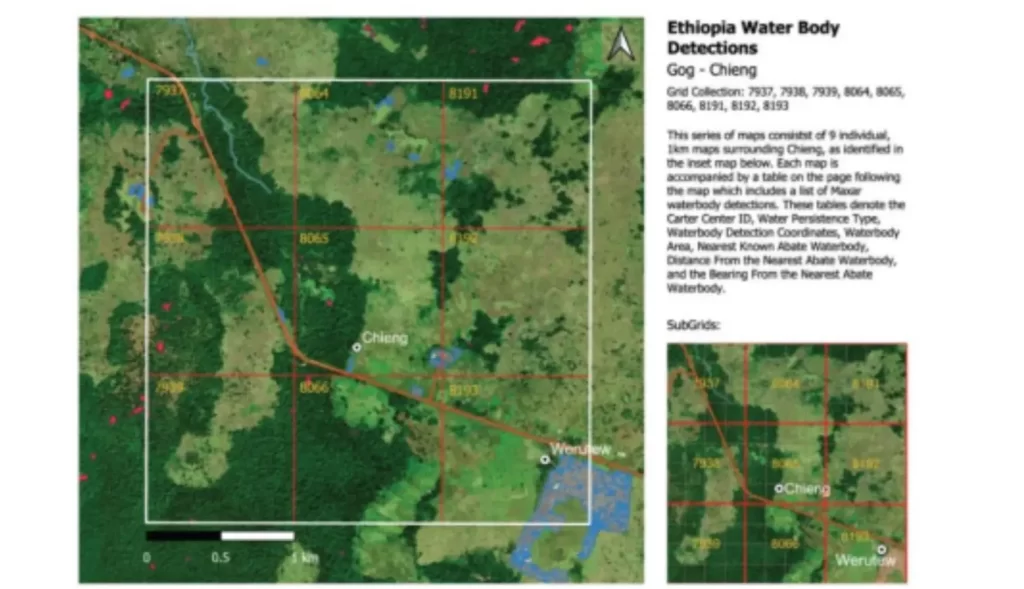
The global campaign is within striking distance of elimination and to accelerate eradication efforts the team is expanding its approach to ensure any previously unknown water sources are identified, treated, and catalogued. This might include seasonal ponds, water collection points deep in hunting forests, or unknown water bodies that may be within the range of village dogs that are known to transmit the disease. To supplement the local efforts and account for these unknown water sources, remote sensing imagery and geospatial analysis can be used to detect and map water bodies. At the onset of our project, Maxar Technologies leveraged their commercial imagery and other data products like digital elevation models (DEMs) to derive locations where water was likely to exist across the Gambela Region of Ethiopia. Once the initial water body extraction work was completed, DevGlobal Partners created PDF maps to assist with field navigation in low/no connectivity environs. DevGlobal and DevAfrique provided initial GIS support by mapping newly detected water bodies alongside the currently known water bodies, and other additional features such as roads, buildings, and landmarks to provide context and aid in navigation. This was all done in collaboration with and with permission from the Ethiopia Federal Ministry of Health, Gambela Region ‘state’ Ministry of Health, and other local officials and community leadership.
Our focus for creating improved maps for The Carter Center and Ethiopia’s National Guinea Worm Eradication Program begins and ends with a user centered design, made possible through consistent interfacing with The Carter Center researchers and scientists, alongside invaluable input from field teams and local experts. This allows us to, for example, coordinate upcoming priority areas and respond to any suspicious reporting trends, better understand what data sources are useful in detecting and navigating to new water bodies and iterate on the maps themselves to fine tune the scale, improve feature visualization and enhance navigational efficiency. After discussions with the Ethiopian field teams, it was determined that these new water bodies could be most easily navigated to by providing distance and direction information from the nearest currently known water bodies. The visual maps combined with distance and bearing allowed the field teams to then use a GPS device and compass to transit to the precise locations. Upon arriving at the water bodies, both known and new, the teams then perform their testing and potential treatment, documenting their work on paper forms. This critical component of field validation of newly detected water bodies also provides invaluable feedback on the accuracy of the derived water bodies.
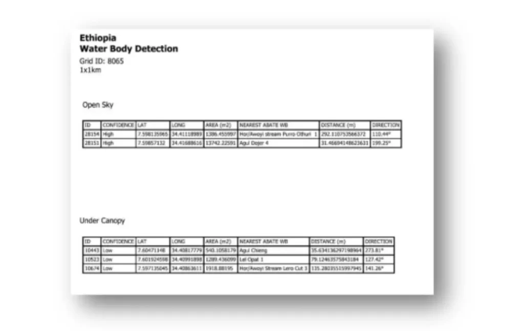
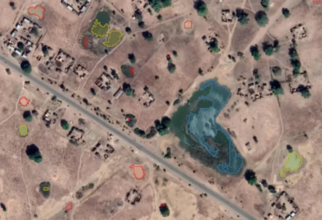
Seen above is an example water body map provided to the Ethiopia field team with accompanying water body detection navigation information seen to the left.
While this is helping to solve part of the problem around identifying previously unknown transmission sites, the process of using PDF maps, a GPS device, compass and paper forms provides an opportunity for improvement. To create an improved experience for Abate teams, the project also focused on the development of a mobile application.
The mobile app enables field teams to navigate to remote waterbodies using GPS technology, reducing the need for traditional navigation methods like compasses and paper maps. This not only saves time, but also ensures that field teams can quickly and accurately locate potential Guinea worm transmission sites. Once at the waterbody, the app allows field teams to log treatment status directly in a central database, replacing the need for spreadsheets and manual data entry. These data can then be used to update the maps and provide real-time information on the status of water sources in the area.
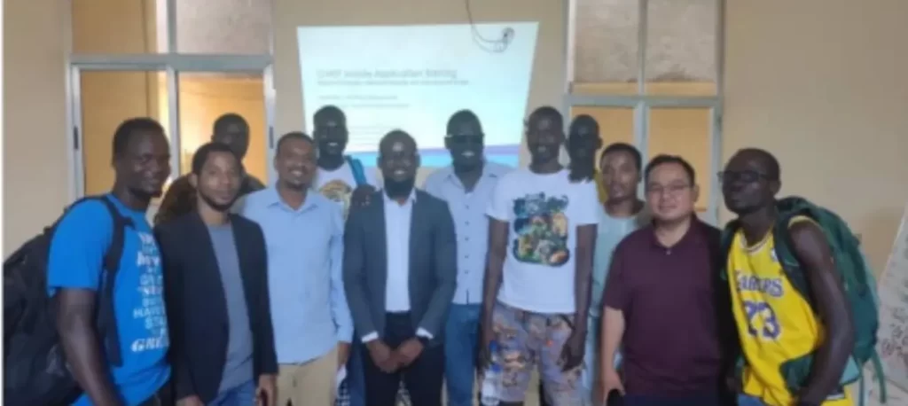
DevAfrique developed the first version of the mobile app and traveled to Gambela, Ethiopia at the beginning of 2023 to deliver an on-site training for Ethiopia’s Guinea Worm Eradication Program. Over the course of a few days, the team piloted the mobile app in the field and gathered critical feedback on improvements that would be integrated in future versions of the application.
The strong collaboration achieved with Ethiopia’s Guinea Worm Eradication Program, The Carter Center and DevGlobal Partners on the mobile application design and mapping efforts are at the core of our work, and the user-centered design of each component will ensure that the transformative power of geospatial technology is a foundational tool in tackling critical public health challenges like disease eradication. By pairing modern geospatial technology and tools with the knowledge of local implementers, this project is enhancing program impact and contributing to the realization of the health and development objectives of The Carter Center and Ethiopia’s Guinea Worm Eradication Program. Guinea worm has been burdening humans for thousands of years, but today it is on the verge of eradication. There is a lot of work left to be done, but together we believe we can realize a day in the near future where Guinea worm is no longer a burden to individuals and humanity.
Rattling excellent info can be found on blog.Raise range
Your article helped me a lot, is there any more related content? Thanks!
Fantastic site Lots of helpful information here I am sending it to some friends ans additionally sharing in delicious And of course thanks for your effort
I do not even know how I ended up here but I thought this post was great I do not know who you are but certainly youre going to a famous blogger if you are not already Cheers
I loved as much as you will receive carried out right here The sketch is tasteful your authored subject matter stylish nonetheless you command get got an edginess over that you wish be delivering the following unwell unquestionably come further formerly again as exactly the same nearly very often inside case you shield this hike